Day 1 Convective Outlook
This product has been superseded. View the updated product →
Issued: · Valid: –
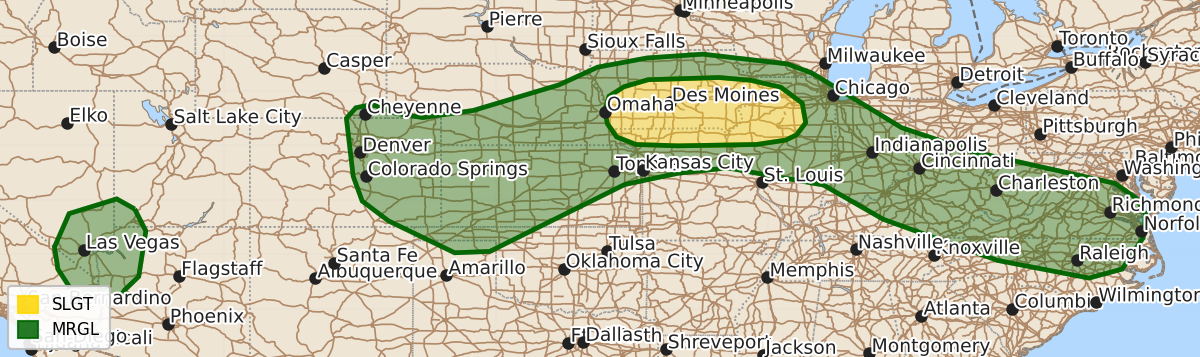
Summary
Strong to severe thunderstorms are possible this afternoon and evening across parts of the mid Missouri and mid Mississippi Valleys, with a risk of damaging gusts and brief tornadoes. Isolated severe gusts are also expected across the central Plains and from the Ohio Valley to the Mid-Atlantic.
Product Text
000 ACUS01 KWNS 141249 SWODY1 SPC AC 141247 Day 1 Convective Outlook NWS Storm Prediction Center Norman OK 0747 AM CDT Fri Aug 14 2026 Valid 141300Z - 151200Z ...THERE IS A SLIGHT RISK OF SEVERE THUNDERSTORMS FOR PARTS OF THE MID MISSOURI AND MID MISSISSIPPI VALLEYS... ...SUMMARY... Strong to severe thunderstorms will be possible this afternoon and evening across parts of the mid Missouri and mid Mississippi Valleys. Isolated severe gusts will also be possible in parts of the central Plains and from the Ohio Valley to the Mid-Atlantic. ...Mid Missouri and mid Mississippi Valleys... An extensive band of showers and thunderstorms currently extends from northeast NE southeastward across central IA, central IL, and central IN. These showers and thunderstorms have been supported by warm-air advection across a relatively broad/diffuse frontal zone extending from southeast NE east-southeastward across northern MO and southern IL. Overall coverage and intensity of these showers and thunderstorms is forecast to gradually wane throughout the morning as the low-level jet responsible for the warm-air advection weakens. Primary severe risk across this region today will be linked to the amount of air mass recovery and associated destabilization that occurs along the southern periphery of this band, ahead of a well-defined MCV generated by overnight convection across KS and NE. Ample low-level moisture is in place, and differential heating between the residual cloud debris from the early morning storms could result in a warm-front-like zone across southern IA or northern MO. Where this boundary sets up, its strength, and its location all still remain uncertain this morning, largely due to the limited predictability of how the ongoing precipitation evolves. The airmass along and south of this boundary is forecast to destabilize and become moderately to strongly unstable by the late afternoon. Additionally, low-level convergence along this boundary should be augmented by mesoscale ascent attendant to the MCV progressing through the region. The resulting combination of lift and buoyancy will support thunderstorm development. A belt of stronger mid-level flow could accompany the MCV, resulting in enough deep-layer shear to support organized storm structures with any persistent updrafts. Strong gusts associated with water-loaded downdrafts, as well as with any bowing segments, are the primary severe risk. Presence of the boundary coupled with southeasterly low-level flow will also support the potential for a brief tornado, particularly early in the convective cycle when a more cellular mode is likely. ...Ohio Valley/Central Appalachians/Mid-Atlantic... Showers and thunderstorms are ongoing from IL into OH. These showers and thunderstorms will likely weaken this morning but associated cloud cover could reinforce a modest baroclinic zone that extends from southern IL across southern IN/southern OH and through central WV/central VA. A modest vorticity max over central IL is forecast to progress southeast within the west-northwesterly mid-level flow along and north of this boundary today. Ascent attendant to this vorticity maximum coupled with low-level convergence and afternoon airmass destabilization will support renewed thunderstorm development. Vertical shear will be weak, but strong updrafts and ample moisture could result in a threat for wet microbursts. ...Central High Plains... A shortwave trough currently moving through the Lower CO River Valley is forecast to continue northeastward through the Four Corners. Ascent associated with this wave will combine with orographic lift in the foothills of the Rockies to support scattered convective initiation by early afternoon. Thunderstorms will then move northeastward into the moderately buoyant airmass over the central High Plains. Deep-layer shear will be modest but sufficient for a few organized updrafts capable of hail and damaging gusts. ...Southern NV Vicinity... Dewpoints are in the 60s across southern CA, the Lower CO River Valley, and southern AZ. Strong heating will support afternoon airmass destabilization, combining with the moisture in place to support moderate buoyancy. Slightly stronger mid-level flow is anticipated over the southern NV vicinity, supporting the potential for isolated strong gusts. ..Mosier/Dean.. 08/14/2026 $$