Day 1 Convective Outlook
This product has been superseded. View the updated product →
Issued: · Valid: –
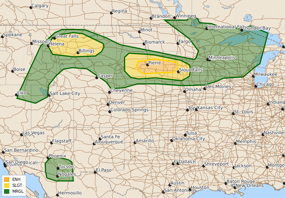
Summary
Severe thunderstorms capable of producing widespread damaging wind gusts are expected across central and eastern South Dakota from late this afternoon through the evening. Isolated to scattered severe storms are also possible in central and eastern Montana during the late afternoon and evening.
Product Text
000 ACUS01 KWNS 251639 SWODY1 SPC AC 251637 Day 1 Convective Outlook NWS Storm Prediction Center Norman OK 1137 AM CDT Sat Jul 25 2026 Valid 251630Z - 261200Z ...THERE IS AN ENHANCED RISK OF SEVERE THUNDERSTORMS FOR CENTRAL INTO EASTERN SOUTH DAKOTA... ...THERE IS A SLIGHT RISK OF SEVERE THUNDERSTORMS IN CENTRAL AND EASTERN MONTANA... ...SUMMARY... Widespread severe gusts are possible across South Dakota late this afternoon through the evening. ...SD into adjacent parts of IA/MN... A prominent upper ridge centered over the central/southern Rockies will feature the southern periphery of appreciably strong mid to high-level flow extending from the Pacific Northwest across the northern High Plains and into the north-central states. Late morning surface analysis shows very hot temperatures ensuing across western NE into the western half of SD with richer moisture (surface dewpoints in the lower to mid 70s F) located over the eastern half of NE/SD. Visible-satellite imagery shows some mid to high clouds across northern WY moving towards the Black Hills. This patch of clouds appears associated with a weak disturbance forecast to move into western SD later this afternoon. Downstream across SD, forecast soundings show very steep surface to 500-mb lapse rates developing as temperatures rise into the 100s F. Expecting initially isolated to widely scattered storms to develop near the Black Hills, as convective temperatures are breached. Models show the gradual development of a cluster moving east across SD early this evening. Have increased severe-wind probabilities to account for observational and model-based trends towards an MCS capable of peak gusts in the 75-90 mph range. This activity will probably slowly weaken towards the MN/IA/SD border but perhaps continue into early overnight with a wind threat. ...MT... Isolated to scattered storms will likely form near the higher terrain of southern MT later this afternoon with a gradual increase in storm coverage as this moves east during the early evening. A hot and well-mixed boundary layer will support severe gusts with the stronger cores and associated outflow. There is some indication this activity will cluster and potentially reach parts of eastern/southeast MT by the late evening. ...Upper Midwest/Upper Great Lakes... Conditional severe potential exists across parts of the Upper Midwest spanning Minnesota to Upper Michigan into Wisconsin. Models continue to show low storm chances as mid-level heights rise through the late evening. Nonetheless, appreciable heating of a seasonably moist boundary layer will result in strong potential buoyancy later today into tonight. Elongated hodographs will support organized storms capable of a wind/hail threat. Given a muted diurnal storm signal in models, the greater chance for isolated storms appears to be associated with warm advection activity late tonight. ...Northeast NV/northern UT/eastern ID... Storm development is expected during the afternoon across parts of northeast Nevada, along the western periphery of the upper ridge. These storms will spread into adjacent parts of southeast Idaho and northwest Utah with time. Isolated severe gusts may accompany the stronger downdrafts. ...South-central/southeast AZ... High-based convection is again expected across southeast Arizona during the afternoon, with initial downburst potential. A modest enhancement to easterly flow along the southern periphery of the upper ridge may allow for localized strong to severe wind gusts to spread westward into parts of south-central Arizona, before convection weakens tonight. ..Smith/Moore.. 07/25/2026 $$