Day 1 Convective Outlook
Issued: · Valid: –
Summary
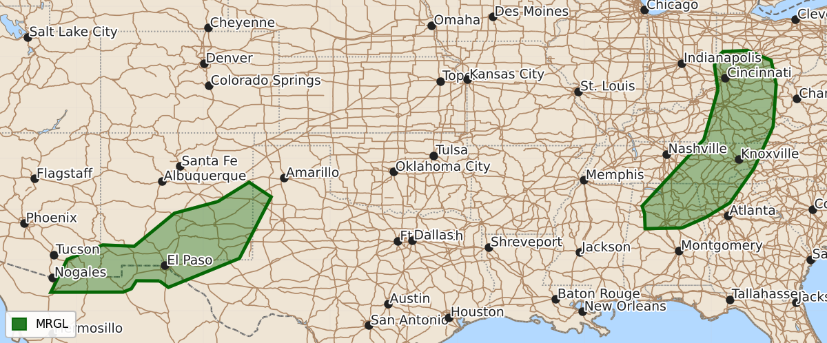
Marginal risk of severe thunderstorms including brief tornadoes and damaging wind gusts will affect parts of the Ohio and Tennessee Valleys as well as the southern Rockies and Great Plains through this evening.
Product Text
000 ACUS01 KWNS 020046 SWODY1 SPC AC 020044 Day 1 Convective Outlook NWS Storm Prediction Center Norman OK 0744 PM CDT Sat Aug 01 2026 Valid 020100Z - 021200Z ...THERE IS A MARGINAL RISK OF SEVERE THUNDERSTORMS THIS EVENING ACROSS PARTS OF THE OHIO AND TENNESSEE VALLEYS AND PARTS OF THE SOUTHERN GREAT PLAINS/ROCKIES... ...SUMMARY... Thunderstorms posing a risk for generally brief, weak tornadoes across the southwestern Ohio vicinity probably will begin to diminish within the next hour or two. Otherwise, locally strong to severe gusts remain possible this evening in continuing thunderstorm development across parts of the Ohio and Tennessee Valleys, and parts of the southern Rockies into adjacent southern Great Plains. ...01Z Update... ...Ohio/Tennessee Valleys... Focused low-level convergence and weak to modest clockwise-curved low-level hodographs, near a surface low now centered to the northwest of the Greater Cincinnati area, have contributed to transient supercell structures within developing convection downstream of an elongating mid-level low across the lower Ohio/middle Mississippi Valley vicinity. Potential for brief/weak tornadoes has probably been boosted by near-surface buoyancy associated with a boundary layer characterized by high relative humidity and surface dew points in the lower 70s, along at least a narrow pre-frontal corridor near the southern Ohio/Indiana state border area into north central Kentucky. However, with the loss of daytime heating, near-surface stabilization probably will diminish this threat by 02-03Z. Otherwise, some intensification of pre-frontal thunderstorm development still appears possible this evening, southward across parts of middle and eastern Tennessee into northern Alabama. Although lower/mid-tropospheric lapse rates are rather modest to weak, seasonably high moisture content is supporting sizable CAPE. Aided by 20-30 kt deep-layer southwesterly mean flow overspreading this environment, heavy precipitation loading and downward momentum transfer could still contribute to potential for localized damaging surface gusts. ...Southern Rockies and adjacent southern Great Plains... Convection developing southward ahead of a weak perturbation within light northerly flow, into a very warm and deeply mixed boundary layer with 40-50 F surface temperature/dew point spreads, may continue to pose a risk for strong to locally severe wind gusts into mid/late evening across parts of southern New Mexico and adjacent portions of western/southwestern Texas and southeastern Arizona. ..Kerr.. 08/02/2026 $$