Day 3 Convective Outlook
Issued: · Valid: –
Summary
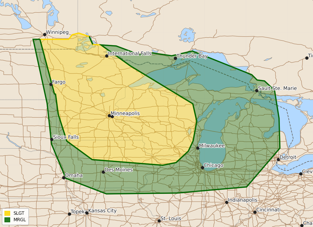
Severe thunderstorms capable of producing large hail and damaging winds are possible across the upper Mississippi Valley, Great Lakes, and portions of the Ohio and mid Missouri Valleys on Sunday and Sunday night.
Product Text
000 ACUS03 KWNS 240708 SWODY3 SPC AC 240707 Day 3 Convective Outlook NWS Storm Prediction Center Norman OK 0207 AM CDT Fri Jul 24 2026 Valid 261200Z - 271200Z ...THERE IS A SLIGHT RISK OF SEVERE THUNDERSTORMS OVER THE UPPER MISSISSIPPI VALLEY INTO UPPER MIDWEST... ...SUMMARY... Severe thunderstorms capable of mainly large hail and damaging winds are possible from the upper Mississippi Valley and Great Lakes into portions of the Ohio and mid Missouri Valleys on Sunday and Sunday night. ...Synopsis... Along the periphery of an upper high anchored over the central and southern Plains, a belt of enhanced mid-level winds will extend from the Pacific Northwest through south-central Canada into the Great Lakes. A series of perturbations will be embedded within the higher-momentum flow regime, the most notable being a disturbance tracking through southern parts of SK and MB into northwest ON and northern MN late Sunday night. A surface low is forecast to follow that same track with an associated trough or weak cool front advancing through the northern Plains into the upper MS Valley. ...Upper Mississippi Valley into the Great Lakes... Boundary-layer dewpoints in the 60s to mid 70s will coincide with an eastward-expanding EML plume and associated cap to yield a fairly widespread reservoir of moderate to strong instability across the region on Sunday. There is some model signal for a subtle mid-level disturbance to progress from the northern Plains into the upper Midwest during the day with an associated band of forcing for ascent potentially serving as a focus for diurnally enhanced thunderstorm development. However, the absence of discernible surface boundaries and the residual capping leads to uncertainty in the location and extent of diurnally enhanced thunderstorm development. Nonetheless, a conditional severe weather threat will exist with any storms that can become rooted within the boundary layer, given the presence of 35-50 kt deep-layer shear. More substantial forcing for ascent is forecast Sunday evening into night across the upper MS Valley with the approach of the mid-level wave mentioned in the synopsis. At that time, the surface front will be moving into the area from the west, potentially serving as a focus for thunderstorm development. The 00Z ECMWF in particular depicts a large thunderstorm complex developing over that area with a subsequent southward movement toward the mid MO Valley Sunday night into early Monday. A corridor of enhanced damaging wind potential would exist in that scenario; however, confidence in such an occurrence is presently too low to include higher probabilities and a conditional intensity group 1 contour. ..Mead.. 07/24/2026 $$