Mesoscale Discussion 1418
Issued: · Valid: –
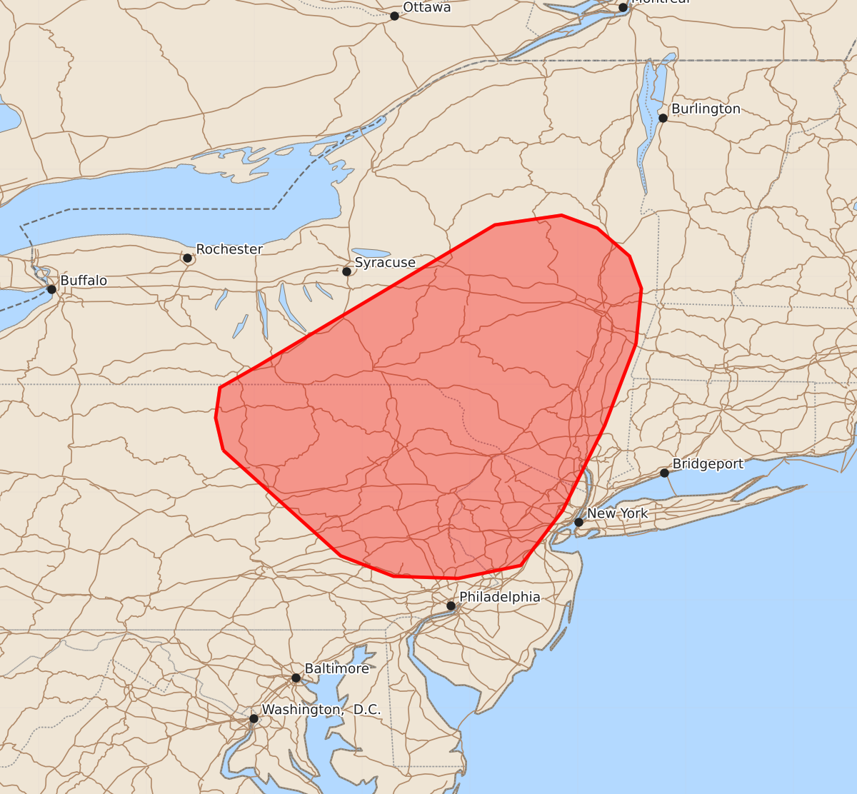
Summary
Severe thunderstorms capable of producing large hail and damaging wind gusts may develop across the northern Appalachians and parts of New England late this afternoon and into the early evening. These storms could potentially organize into transient supercells or clusters bringing moderate to high severity.
Product Text
000 ACUS11 KWNS 011802 SWOMCD SPC MCD 011801 NYZ000-NJZ000-PAZ000-012000- Mesoscale Discussion 1418 NWS Storm Prediction Center Norman OK 0101 PM CDT Wed Jul 01 2026 Areas affected...The northern Appalachians and portions of the New England region Concerning...Severe potential...Watch possible Valid 011801Z - 012000Z Probability of Watch Issuance...60 percent SUMMARY...Watch issuance may be needed as thunderstorms develop within a very buoyant, but modestly sheared, environment across parts of the northern Appalachians/New England region. DISCUSSION...MLCIN has largely eroded across the greater PA/NY/NJ region as temperatures climb into the upper 80s/low 90s within a very moist air mass. Although MLCAPE has increased to around 3000 J/kg, only a couple of deeper convective showers and at least one sustained thunderstorm are noted in GOES imagery within a broader field of otherwise shallow cumulus. This suggests that regional forcing for ascent remains fairly weak and localized for the time being. With the apex of the upper ridge pivoting over the region and relatively weak low-level flow/confluence, forcing for ascent is expected to remain somewhat nebulous through late afternoon. However, continued daytime heating should allow near-surface parcels to reach their convective temperatures. Localized ascent either within subtle confluence axes and/or along terrain features should promote additional isolated thunderstorm development by late mid to late afternoon (most likely between 19-22 UTC based on recent CAM solutions). Once this occurs, thunderstorm coverage may gradually increase as new convection develops along outflow boundaries given the uninhibited and strongly buoyant environment (though CAM guidance continues to show high variance regarding thunderstorm coverage though early evening). Regardless, 30-35 knot mid-level flow may promote some convective organization and the emergence of transient supercells and/or loosely organized clusters capable of large hail and severe gusts. Watch issuance may be needed based on when/where robust thunderstorm development occurs. ..Moore/Guyer.. 07/01/2026 ...Please see www.spc.noaa.gov for graphic product... ATTN...WFO...OKX...ALY...PHI...BGM...CTP... LAT...LON 41397729 41697736 41977732 42177697 43487477 43577415 43457382 43197352 42897341 42387346 41627375 40837414 40327453 40207511 40227571 40417620 41397729 MOST PROBABLE PEAK WIND GUST...55-70 MPH MOST PROBABLE PEAK HAIL SIZE...1.00-1.75 IN