Mesoscale Discussion 1632
Issued: · Valid: –
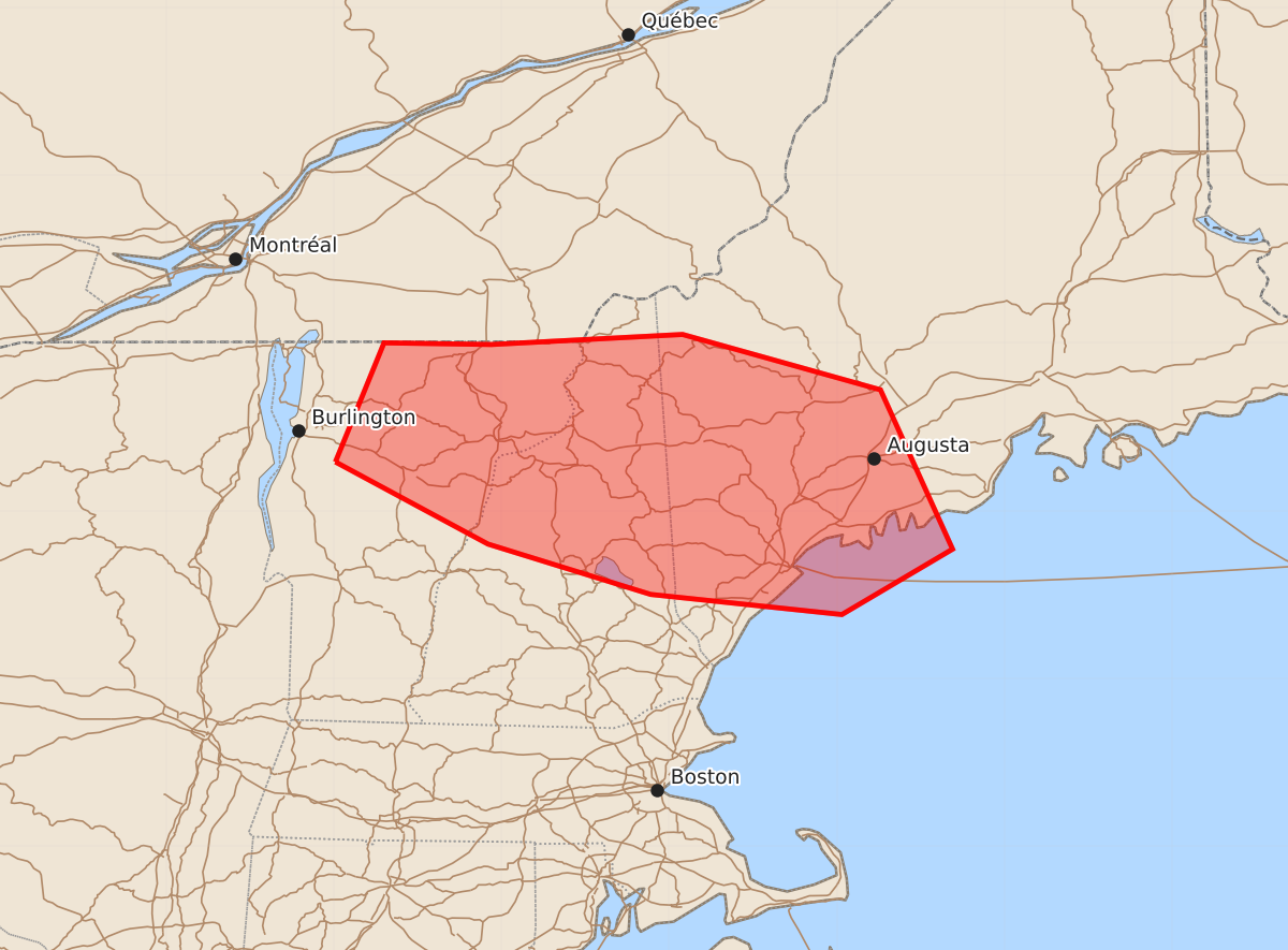
Summary
A band of showers and thunderstorms may produce damaging wind gusts across parts of northern Vermont, northern and central New Hampshire, and western Maine from noon to 3 pm EDT. Expected wind gusts could reach speeds of 55 to 70 mph.
Product Text
000 ACUS11 KWNS 161547 SWOMCD SPC MCD 161546 MEZ000-NHZ000-VTZ000-161815- Mesoscale Discussion 1632 NWS Storm Prediction Center Norman OK 1046 AM CDT Thu Jul 16 2026 Areas affected...parts of northern Vermont...northern and central New Hampshire...western Maine Concerning...Severe potential...Watch possible Valid 161546Z - 161815Z Probability of Watch Issuance...40 percent SUMMARY...A developing band of showers and thunderstorms may become increasingly accompanied by strong to potentially damaging wind gusts while overspreading the region through noon to 3 pm EDT. DISCUSSION...A vigorous mid-level trough is in the process of digging across the St. Lawrence Valley into the northeast, accompanied by a more significant, reinforcing cold front now already overspreading the higher terrain of northwestern Maine through the international border vicinity south of Montreal. In the wake of preceding low-level cooling and drying, the boundary-layer along and ahead of the front across New England remains only modestly moist. However, forcing for ascent along the front, near the leading edge of stronger mid-level cooling (characterized by 500 mb temperatures falling into and below the -16-18 C range) has been sufficient to support a narrow band of modestly deeper convective development capable of producing occasional lightning. With at least some further boundary-layer warming, mixing and steepening of low-level lapse rates, it appears that this activity could increase and intensify at least a bit further while overspreading the northern Vermont/New Hampshire into western Maine vicinity through 16-19Z. Coincident with strengthening mid-level wind fields, perhaps including in excess of 50 kt to near and below the 700 mb level, convection may increasing aid the downward transport of stronger momentum to the surface, accompanied by potentially damaging surface wind gusts. ..Kerr/Guyer.. 07/16/2026 ...Please see www.spc.noaa.gov for graphic product... ATTN...WFO...GYX...BTV... LAT...LON 44297299 45007270 44997206 45057092 44726974 43776931 43386997 43507111 43807208 44297299 MOST PROBABLE PEAK WIND GUST...55-70 MPH