Day 1 Convective Outlook
Issued: · Valid: –
Summary
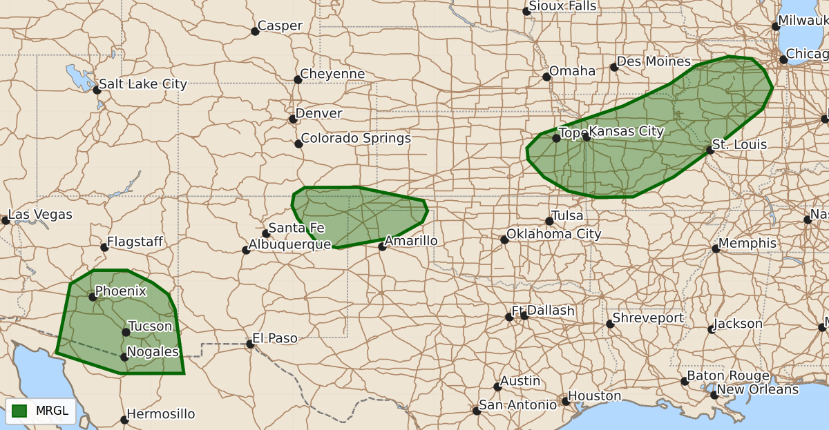
Isolated severe thunderstorms capable of producing wind gusts and hail are possible this evening across parts of the central Plains, Ozarks, mid Mississippi Valley, southern High Plains, and southern Arizona. These storms are expected to be localized with marginal severity.
Product Text
000 ACUS01 KWNS 060046 SWODY1 SPC AC 060044 Day 1 Convective Outlook NWS Storm Prediction Center Norman OK 0744 PM CDT Wed Aug 05 2026 Valid 060100Z - 061200Z ...THERE IS A MARGINAL RISK OF SEVERE THUNDERSTORMS ACROSS PARTS OF THE CENTRAL PLAINS...OZARKS...MID MISSISSIPPI VALLEY...SOUTHERN HIGH PLAINS AND SOUTHERN ARIZONA.... ...SUMMARY... Thunderstorms with severe wind gusts and hail will be possible this evening in parts of the central Plains, Ozarks, mid Mississippi Valley, southern High Plains and southern Arizona. ...Central Plains/Ozarks/Mid Mississippi Valley... The latest water vapor imagery shows a broad area of cyclonic flow over the north-central U.S., with an embedded shortwave trough in the mid Mississippi Valley. At the surface, an ill-defined front is located from far southern Kansas northeastward into Missouri and Illinois. Scattered thunderstorms are ongoing on the cool side of the boundary in northern Missouri. Along and to the south of the front, surface dewpoints are in the 70s F, and the RAP has MLCAPE in the 1500 to 2500 J/kg range. In addition, the WSR-88D VWP at St. Louis has 0-6 km shear around 30 knots, and veering winds with height in the lowest 1 Km above ground level. This environment will be sufficient for isolated severe wind gusts and hail this evening. However, forecast soundings have poor lapse rates which will keep any severe threat localized. ...Southern High Plains... Mid-level flow is west-northwesterly over much of the High Plains this evening. A small pocket of moderate instability is analyzed by the RAP over southeastern Colorado. Thunderstorms are ongoing to the south of the instability max over northeastern New Mexico. These storms will move east-southeastward into the northwestern Texas Panhandle and western Oklahoma Panhandle this evening. MLCAPE around 1000 J/kg with 0-6 km shear in the 30 to 40 knot range, along with steep low to mid-level lapse rates could be enough for isolated severe gusts and hail. ...Southern Arizona... The latest RAP analysis shows moderate instability over most of southern Arizona, where MLCAPE is estimated in the 1000 to 2000 J/kg range. Thunderstorms are developing in the higher terrain of eastern Arizona, and these storms will move west-southwestward across southern Arizona this evening. RAP forecast sounding at Tuscon early this evening have 0-3 km lapse rates in the 8 to 8.5 C/km range, along with surface temperature-dewpoint spreads exceeding 30 degrees F. This will contribute to a potential for isolated severe gusts in southern Arizona over the next few hours...see MCD 1838. ..Broyles.. 08/06/2026 $$