Day 1 Convective Outlook
This product has been superseded. View the updated product →
Issued: · Valid: –
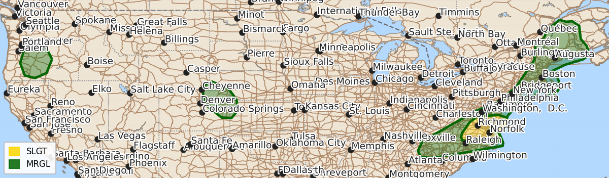
Summary
Damaging wind gusts from severe thunderstorms are possible across the southern Mid-Atlantic and New England this afternoon and evening. Isolated severe wind gusts are also expected in the central High Plains and central Oregon during the afternoon and evening.
Product Text
000 ACUS01 KWNS 220552 SWODY1 SPC AC 220550 Day 1 Convective Outlook NWS Storm Prediction Center Norman OK 1250 AM CDT Wed Jul 22 2026 Valid 221200Z - 231200Z ...THERE IS A SLIGHT RISK OF SEVERE THUNDERSTORMS ACROSS THE SOUTHERN MID-ATLANTIC... ...SUMMARY... Isolated to scattered storms are possible in the southern Mid-Atlantic into New England this afternoon/evening. Damaging winds are the primary concern. Isolated strong to severe wind gusts are also possible in the central High Plains and central Oregon. ...Synopsis... A upper trough will persist in the Northeast CONUS with a ridge amplifying into the Northwest. An offshore upper low in the Northwest will eject shortwave perturbations into Oregon/Washington. At the surface, a cold front will move through New England. The front will slow in the Mid-Atlantic during the afternoon before moving southeast during the overnight. ...Mid-Atlantic into parts of Carolinas... The cold front in this region is expected to slow/stall near the Blue Ridge into eastern Maryland. Models suggest clouds/precipitation will be likely in the vicinity of the Virginia/North Carolina border. Mid-level forcing for ascent will be weak at best and subtle mid-level warming is expected from far southern Virginia into the Carolinas. Moderate to strong mid-level winds will be in place with the strongest flow in Virginia/Maryland. It is not clear how convection will evolve during the day/afternoon. Storms could potentially continue from the morning into the afternoon over portions of the region. There also is potential for storms to develop along the cold front where there could potentially be greater surface heating. In the Carolinas, the lack of ascent and cloud cover concerns limit confidence in how many storms and how strong they will become. Greater confidence in storm coverage exists in Virginia into the DelMarVa where the Slight Risk has been maintained. The kinematic environment will support occasionally organized storms capable of damaging winds and perhaps a tornado or two. ...New England... A strong mid-level jet will be favorably timed during the afternoon, particularly for New Hampshire/Maine. As the cold front moves through, scattered storms appear probable. Effective shear of 30-40 kt and strong upper-level winds will promote supercell structures. The shear vector will have a large component parallel to the north-south cold front so it is not clear how long discrete structures can be maintained. Isolated damaging winds, marginally severe hail, and perhaps a tornado would be possible. Some consideration was given to a higher severe probabilities, but the region will initially be in the wake of a shortwave trough and thermodynamic profiles exhibit characteristics (e.g., mid-level inversion, lowered equilibrium level) that limits confidence in how many severe-caliber storms will exist. Farther south and west, there is less signal for convective development along the cold front. A Marginal risk has been maintained this outlook cycle. Some risk for damaging winds would exist if an isolated storm can develop along the front. ...Central High Plains... Southeasterly surface winds will combine with increasingly westerly/northwesterly flow aloft to promote modest deep-layer shear (around 30 kt 0-6 km) during the afternoon/evening. The development of a weak lee low and low-level moisture moving northwest around the Midwest anticyclone will aid in storm development within the region. Temperature-dewpoint spreads at the surface will allow for efficient outflow production. A strengthening southeasterly low-level jet in western Kansas may also help maintain convection farther east during the evening. Severe wind gusts are possible with this activity. ...Oregon... An upper-low will be positioned off the Northwest Coast. Subtle ascent will help to initiate storms in parts of central Oregon during the afternoon. Models are in strong agreement that scattered storms will move northward into at least early evening. Strong heating will lead to large temperature-dewpoint spreads at the surface. Inverted-v thermodynamic profiles will promote a risk for strong to severe wind gusts despite limited buoyancy and shear. ..Wendt/Weinman.. 07/22/2026 $$