Mesoscale Discussion 1253
Issued: · Valid: –
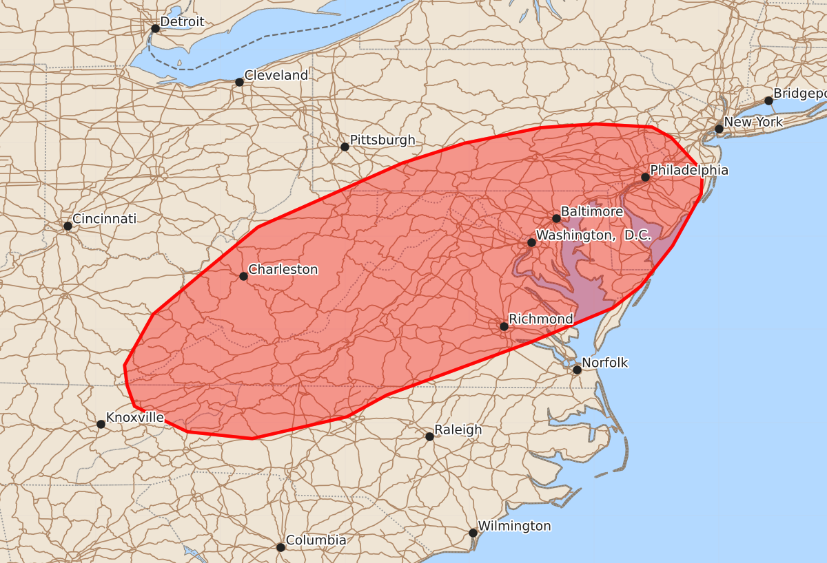
Summary
Severe thunderstorms capable of producing damaging wind gusts, isolated hail, and possible tornadoes are expected across portions of the central Appalachians and Mid-Atlantic through this evening. The most significant risks include wind gusts up to 70 mph and hail up to 1.25 inches.
Product Text
000 ACUS11 KWNS 221725 SWOMCD SPC MCD 221725 NJZ000-PAZ000-MDZ000-DEZ000-VAZ000-DCZ000-WVZ000-NCZ000-TNZ000-KYZ000-221930- Mesoscale Discussion 1253 NWS Storm Prediction Center Norman OK 1225 PM CDT Mon Jun 22 2026 Areas affected...portions of the central Appalachians into the Mid-Atlantic Concerning...Severe potential...Watch likely Valid 221725Z - 221930Z Probability of Watch Issuance...80 percent SUMMARY...Thunderstorms will increase in coverage and intensity over the next couple of hours. Scattered damaging wind gusts, isolated hail and perhaps a tornado will be possible through evening. A severe thunderstorm watch will likely be needed by 19z. DISCUSSION...Thunderstorms over the higher terrain of WV and vicinity are gradually increasing in intensity this afternoon as gradual destabilization occurs. Downstream from higher terrain across portions of VA into MD/DE, southern NJ and southeast PA, stronger heating is occurring within areas of mostly clear skies. Higher quality moisture across eastern VA has been streaming northward toward southeast PA/southern NJ and ensuing stronger destabilization is noted. Enhanced westerly flow is apparent in early afternoon mesoanalysis and 12z regional RAOBs. This should allow for sufficient deep layer shear for storm organization. Thunderstorm clusters will pose mainly a risk of damaging wind gusts given steep (greater than 7.5 C/km) 0-3 km lapse rates and PW values around 1.75 inches. Some forecast guidance suggests sufficient clustering/outflow consolidation may occur in the vicinity of northern VA/MD and a forward propagating cluster/bowing segment could develop and track northeast with time toward southeast PA/NJ. This corridor aligns with the corridor of stronger midlevel westerlies, and may pose a relative greater severe risk compared to points further south into southern VA and NC where flow is weaker. If this scenario unfolds, damaging wind potential will increase. Given modest 0-1 km SRH across the region, a tornado or two also could occur, though the damaging wind risk is expected to be the primary hazard into early evening. ..Leitman/Hart.. 06/22/2026 ...Please see www.spc.noaa.gov for graphic product... ATTN...WFO...PHI...AKQ...CTP...LWX...RAH...RNK...PBZ...RLX... GSP...MRX...JKL... LAT...LON 40497808 40747686 40807597 40757507 40587476 40047426 39677428 38847474 38197525 37847570 37297702 36447933 36097997 35748149 35858253 36268338 36608350 36928354 37748308 38378233 39148140 40177908 40497808 MOST PROBABLE PEAK TORNADO INTENSITY...UP TO 90 MPH MOST PROBABLE PEAK WIND GUST...55-70 MPH MOST PROBABLE PEAK HAIL SIZE...UP TO 1.25 IN