Day 1 Convective Outlook
Issued: · Valid: –
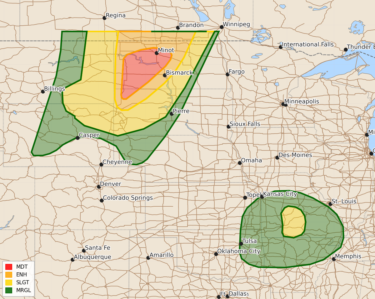
Summary
Severe thunderstorms with the potential for 75 mph wind gusts, large hail, and an isolated tornado are expected across western North Dakota and far northwestern South Dakota this evening. Additionally, the Ozarks in southern and central Missouri may experience tornadoes and strong wind gusts tonight.
Product Text
000 ACUS01 KWNS 080102 SWODY1 SPC AC 080100 Day 1 Convective Outlook NWS Storm Prediction Center Norman OK 0800 PM CDT Sun Jun 07 2026 Valid 080100Z - 081200Z ...THERE IS A MODERATE RISK OF SEVERE THUNDERSTORMS ACROSS PARTS OF WESTERN NORTH DAKOTA AND FAR NORTHWESTERN SOUTH DAKOTA... ...THERE IS A SLIGHT RISK OF SEVERE THUNDERSTORMS ACROSS SOUTHWEST AND SOUTH-CENTRAL MISSOURI... ...SUMMARY... A line of severe thunderstorms with wind gusts potentially above 75 mph is expected over the northern High Plains this evening, with large to very large hail and an isolated tornado threat also possible. A couple of tornadoes and isolated damaging gusts are also possible in the Ozarks. ...Northern High Plains... At mid-levels, an upper-level trough is moving eastward into the northern Rockies. Further east, a lead shortwave trough is evident on water vapor imagery over the northern High Plains. At the surface, a 994 mb low is located in northwestern North Dakota with a surface trough extending southward into northwestern South Dakota. A cold front is in far western North Dakota. To the east of the front, surface dewpoints are mostly in the upper 50s and lower 60s F, and moderate instability is in place. Numerous thunderstorms have recently developed to the west of the instability axis, and these storms are expected to organize into an intense line segment over the next couple of hours. RAP forecast soundings in western North Dakota ahead of the storms have 0-6 km shear in the 40 to 55 knot range, with 850 to 500 mb lapse rates between 7.5 and 8 C/km. In addition, surface temperature-dewpoint spreads exceed 25 degrees F over much area. This environment will be very favorable for severe wind gusts. The greatest potential for severe gusts will be from far northwest South Dakota northeastward into much of western and north-central North Dakota. Along this corridor, a nearly continuous bowing line is expected to organize. Severe wind gusts above 75 mph will be possible with the more intense segments. In addition to the wind-damage threat, large to very large hail will be possible over the next couple hours with storms that obtain supercell structure. A tornado or two could also occur. ...Ozarks... A mid-level trough will move northeastward across the central U.S. this evening. Ahead of the trough, a moist and unstable airmass is in place from the southern and central Plains eastward into the lower to mid Mississippi Valley. Scattered strong thunderstorms are ongoing along an axis of moderate instability over the Ozarks of southern and central Missouri, where the RAP has MLCAPE in the 1500 to 2000 J/kg range. Ahead of the mid-level trough, low-level flow is forecast to become maximized in the Ozarks over the next couple of hours. Forecast soundings near Springfield, Missouri by 03Z have 0-3 km storm-relative helicity around 180 m2/s2. This will support a tornado threat. A few strong wind gusts will also be possible. ..Broyles.. 06/08/2026 $$