Day 1 Convective Outlook
This product has been superseded. View the updated product →
Issued: · Valid: –
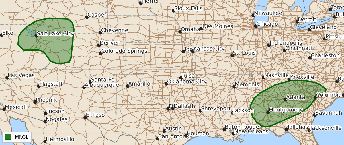
Summary
Isolated severe wind gusts and hail are possible this afternoon and evening for parts of Utah, southwest Wyoming, and western Colorado, while thunderstorms capable of damaging winds may affect portions of the Southeast through the early evening.
Product Text
000 ACUS01 KWNS 221958 SWODY1 SPC AC 221956 Day 1 Convective Outlook NWS Storm Prediction Center Norman OK 0256 PM CDT Tue Sep 22 2026 Valid 222000Z - 231200Z ...THERE IS A MARGINAL RISK OF SEVERE THUNDERSTORMS FOR MUCH OF UTAH INTO ADJACENT PARTS OF WYOMING AND COLORADO... AND ACROSS A PORTION OF THE SOUTHEAST... ...SUMMARY... An isolated threat for severe wind gusts is expected today in Utah into southwest Wyoming and western Colorado. Thunderstorms capable of strong to locally severe damaging gusts are also possible across parts of the Southeast. ...20Z Update Southeastern US... The primary forecast update was to move the Marginal Risk area further south and east into central Georgia and southern Alabama, where thunderstorms have developed in an unstable airmass with steep low-level lapse rates. While a lack of vertical shear will support a disorganized storm mode, water-loaded downdrafts and associated severe thunderstorm gusts will be possible this afternoon into the early evening. Additional thunderstorm development along the diffuse cold front across Tennessee into northern Alabama will continue to progress into the Marginal Risk area, posing a primarily damaging wind threat. Otherwise, the forecast largely remains on track with minor adjustments to the thunder area based on current guidance. Damaging wind gusts are still anticipated this afternoon across portions of Utah into southwestern Wyoming and western Colorado. See the previous discussion for more detail. ..Halbert/Lyons.. 09/22/2026 .PREV DISCUSSION... /ISSUED 1124 AM CDT Tue Sep 22 2026/ ...Utah into southwest Wyoming and western Colorado... Recent water-vapor imagery shows a potent shortwave trough over the western Great Basin. Recent mesoanalysis estimates a belt of stronger mid-level flow extends throughout the eastern periphery of this wave from northern AZ into central UT. This shortwave is forecast to continue slowly northeastward today, with the accompanying belt of stronger flow extending through northern UT into western WY. Scattered to numerous thunderstorms are expected this afternoon and evening across the region as lift attendant to this wave interacts with the modestly moist and buoyant airmass across the region. Buoyancy will likely remain modest (i.e. MLCAPE less than 1000 J/kg. Even so, moderate to strong vertical shear associated with the stronger mid-level flow will support organized storm structures. This shear combined with cold mid-level temperatures will support the potential for large hail. Additionally, high cloud bases and steep low-level lapse rates suggest strong gusts are possible with any of the more robust storms. This activity will eventually move into western CO and southwest WY towards the late afternoon/early evening with isolated severe gusts and/or large hail remaining possible within the stronger cores and associated outflows. ...Southeast... Recent surface analysis places a diffuse cold front from the Arklatex northeast into far western VA where it intersects the wedge front over the Mid-Atlantic. This front is expected to gradually shift southward today, interacting with the moist airmass across the Southeast to support thunderstorm development. The strongest buoyancy (i.e. 1500 to 2000 J/kg of MLCAPE) is expected from western/central SC into central AL, where afternoon temperatures will likely reach the 90s amid low 70s dewpoints. Weak low to mid tropospheric flow was sampled by regional soundings, with the very weak vertical shear limiting the overall storm strength and persistence. Some of the stronger water-loaded downdrafts could produce strong gusts with pockets of wind damage into the early evening. Low wind probabilities were trimmed out of southwest VA and adjacent western NC/northeast TN where temperatures will remain cool, limiting buoyancy. Low wind probabilities were also trimmed across central MS where only isolated storm coverage is anticipated. $$