Day 2 Convective Outlook
Issued: · Valid: –
Summary
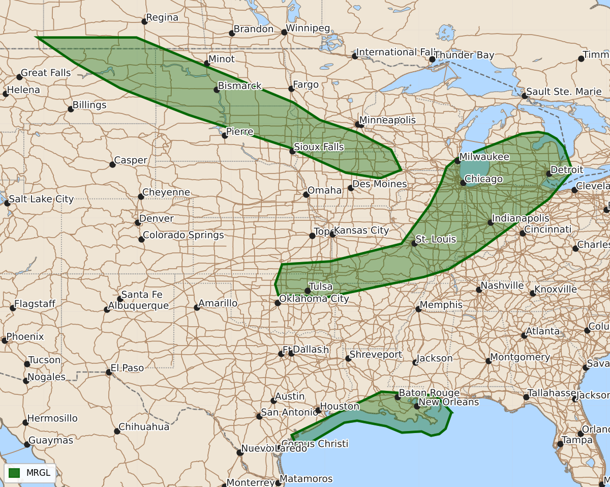
Isolated strong to severe thunderstorms are possible Tuesday afternoon and evening across parts of the Midwest and Lower Michigan, with additional severe storms possible Tuesday night across the northern Plains and Upper Midwest. A marginal risk of severe storms also exists for the western and central Gulf Coast on Tuesday.
Product Text
000 ACUS02 KWNS 151729 SWODY2 SPC AC 151728 Day 2 Convective Outlook NWS Storm Prediction Center Norman OK 1228 PM CDT Mon Jun 15 2026 Valid 161200Z - 171200Z ...THERE IS A MARGINAL RISK OF SEVERE THUNDERSTORMS FOR PORTIONS OF THE NORTHERN PLAINS INTO THE UPPER MIDWEST...THE GREAT LAKES TO THE CENTRAL PLAINS...AND THE WESTERN/CENTRAL GULF COAST.... ...SUMMARY... Isolated to scattered strong to severe thunderstorms are possible Tuesday afternoon and evening across parts of the Midwest into Lower Michigan. Additional strong to severe storms are possible across the northern Plains into the Upper Midwest Tuesday night. ...Synopsis... A belt of moderate to strong mid-level flow will extend from the Northwest to the northern Plains and the Midwest and to the Mid-Atlantic on Tuesday. Within this flow, a mid-level shortwave trough will move through the Great Lakes. An additional, stronger shortwave trough will amplify across the northern Plains toward the end of the period. A weak surface low will move through the northern Great Lakes through the day and weaken while an associated cold front moves across the Midwest and eventually stalls toward the end of the period. A stronger surface low will develop across the northern Plains Tuesday night and will be located somewhere near eastern South Dakota by the end of the period. ...Midwest to the Central Plains... Strengthening lower tropospheric flow will transport moisture northward ahead of a cold front tomorrow morning/afternoon with weak to potentially moderate instability expected. An initial line of storms will likely develop on the leading edge of the returning moisture in a more well-mixed and uncapped environment. This activity will likely stay sub-severe, but a few isolated damaging wind gusts will be possible given the steep low-level lapse rates and strengthening flow. The greater severe weather potential is expected along the cold front during the afternoon where upper 50s to low 60s dewpoints should be present. Cloud-cover from initial activity should limit overall instability (and a more substantial threat), but cooling temperatures aloft should provide adequate instability for strong to severe storms along the front. The strong shear across the region will support the potential for rotating updrafts capable of isolated large hail, damaging wind gusts, and perhaps a tornado. If instability trends increase, an upgrade to Slight Risk (Level 2/5) may be necessary in later outlooks across northern Indiana, southern Michigan and northwest Ohio. ...Northern Plains to the Upper Midwest... Tuesday night, as the mid-level trough amplifies across the northern Plains, the frontal zone across the northern Plains will tighten. Instability is forecast to be relatively weak initially, but strong forcing from dCVA across the region, strengthening isentropic ascent due to the strengthening cyclone, and strong shear beneath the 100+ knot 300mb jet streak will provide an environment that supports isolated strong to severe storms along the frontal zone despite the weak instability. Within this larger marginal risk region, a greater severe threat may exist shortly before 12Z across northern Iowa and vicinity. Here richer 850 moisture, advected by the strengthening low-level jet, will yield greater elevated instability (1500 to 2000 J/kg MUCAPE). This will provide an environment featuring moderate instability and strong shear amid strengthening isentropic ascent. ...Gulf Coast... Most guidance shows a MCV developing across northern Mexico/south Texas today, which is already somewhat apparent across the region. This feature is forecast to move into the western Gulf on Tuesday. Strengthening flow associated with this MCV will overspread the Texas and Louisiana Coast tomorrow. A tropical environment will be present with weak mid-level lapse rates. However, this strengthening flow may support an isolated tornado threat from the central Texas Coast to the eastern Louisiana Coast. ..Bentley.. 06/15/2026 $$