Day 2 Convective Outlook
Issued: · Valid: –
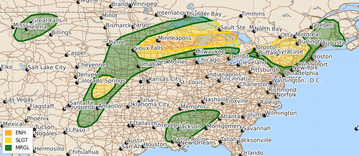
Summary
Severe thunderstorms are expected Wednesday across the Upper Midwest, Great Lakes, Northeast, and central High Plains, bringing risks of damaging wind gusts up to 80 mph, large hail, and isolated tornadoes. Additional severe storms capable of producing damaging winds and hail are possible throughout the afternoon and evening across parts of the Southern Mississippi and Tennessee Valleys and Montana.
Product Text
000 ACUS02 KWNS 301747 SWODY2 SPC AC 301745 Day 2 Convective Outlook NWS Storm Prediction Center Norman OK 1245 PM CDT Tue Jun 30 2026 Valid 011200Z - 021200Z ...THERE IS AN ENHANCED RISK OF SEVERE THUNDERSTORMS ACROSS SOUTHERN MINNESOTA INTO PARTS OF NORTHERN/CENTRAL WISCONSIN AND NORTHERN LOWER MICHIGAN... ...THERE IS A SLIGHT RISK OF SEVERE THUNDERSTORMS ACROSS PORTIONS OF THE NORTHEAST AND THE CENTRAL HIGH PLAINS... ...SUMMARY... Scattered severe storms will again be possible across the Upper Midwest/Great Lakes Wednesday into Wednesday night. Damaging wind gusts (some to 80 mph) are expected, in addition to isolated large to very large hail and a few tornadoes. Additional severe storms, posing mainly a damaging wind risk, are possible across parts of the Northeast and the central High Plains. ...Synopsis... An upper shortwave trough will move across the Upper Midwest and Great Lakes Wednesday, eventually flattening the upper ridge over the Northeast late in the period. With this shortwave, a band of enhanced mid/upper-level southwesterly flow will overspread the Upper Midwest and Great Lakes. A quasi-stationary surface boundary will extend from eastern SD northeast toward Lake Superior. Along and south of this boundary will be a focus for potentially multiple rounds of severe thunderstorms Wednesday and Wednesday night across the Upper MS Valley/Great Lakes. Additional strong to severe storms are expected across the Northeast, the South, the central/southern High Plains, and portions of Montana. ...Upper Midwest/Great Lakes vicinity... A somewhat similar pattern compared to previous days is expected on Wednesday. However, the upper trough moving across the region will be a bit strong as the upper low over the Canadian Prairies finally becomes more progressive. A belt of 50-70 kt southwesterly flow between 700-500 mb is noted in various forecast guidance, supporting 40+ kt effective shear magnitudes and supercell wind profiles. The boundary layer continues to be very moist, with dewpoints in the mid 60s to mid 70s present beneath modestly steep midlevel lapse rates, resulting in strong to extreme buoyancy. Convection may be ongoing early in the period near southern MN, though where exactly these storms are located depends on convective evolution in the current Day 1/Tuesday period. This convection could be severe with a risk for damaging winds and hail. It is possible this activity could develop east/northeast along the surface boundary and intensify through the morning/afternoon as it moves across WI and pose a severe risk of damaging winds. Or, it could weaken and additional severe storms could develop near the surface boundary across WI/northern MI during the day. Another round of convection is expected to develop during the evening across southern MN. This activity could initially be supercells, with an accompanying all-hazards severe risk. However, storms are expected to quickly grow upscale into a bowing MCS, moving east/northeast through the nighttime hours across WI/MI. While exact convective evolution is uncertain, it does appear that more than one round of severe storms is possible across the region on Wednesday. Swaths of damaging winds (some to near 80 mph) appear likely. Isolated large to very large hail also is possible, especially if any supercell storm mode can persist. A few tornadoes also will be possible. ...Northeast... Enhanced west/northwesterly flow will continue on Wednesday across the region. Another day of very moist and hot conditions is expected, supporting a corridor of strong to extreme buoyancy. Thunderstorm clusters posing a damaging wind and isolated hail risk will be possible during the afternoon. More organized convection is expected to sweep across the region during the evening/overnight hours as the upper ridge breaks down with the approach of an upper shortwave trough over the Upper Great Lakes. Organized convection over Ontario/Quebec will likely move east/southeast during the nighttime hours and pose a risk for damaging wind gusts. ...Central/Southern High Plains... Convection is expected to develop along a surface dryline Wednesday afternoon/evening. Vertically veering wind profiles will increase southwesterly flow aloft will support transient supercell structures initially. Forecast hodographs show 25 kt effective shear magnitudes amid long/straight hodographs. Strong/severe outflow winds will be possible, along with isolated hail. Sufficient clustering/outflow consolidation may occur, supporting greater wind potential, particularly across the western KS vicinity. ...Lower MS/TN Valleys vicinity... A similar pattern will exist across the region on Wednesday on the southern periphery of the upper anticyclone over the eastern U.S. Forecast guidance once again depicts modest midlevel east/northeasterly flow providing support for 20-25 kt effective shear magnitudes. Thunderstorm clusters will develop during the afternoon within the theta-e axis. The very moist and abundantly unstable airmass will support a wet microburst risk. If sufficient clustering occurs, some potential for forward propagating convection will exist, which could increase damaging wind potential through early evening. ...MT... An upper trough over the western U.S. will bring modestly enhanced southwesterly mid/upper flow across portions of the northern Rockies Wednesday afternoon/evening. A plume of steeper midlevel lapse rates will gradually spread northeast from the Great Basin into parts of southwest/central MT atop modest low-level moisture. This will support 500-1000 J/kg MLCAPE. Steep low-level lapse rates and sufficient vertical shear for organized cells/clusters will result in a risk for isolated strong to severe wind gusts. ..Leitman.. 06/30/2026 $$