Day 1 Convective Outlook
Issued: · Valid: –
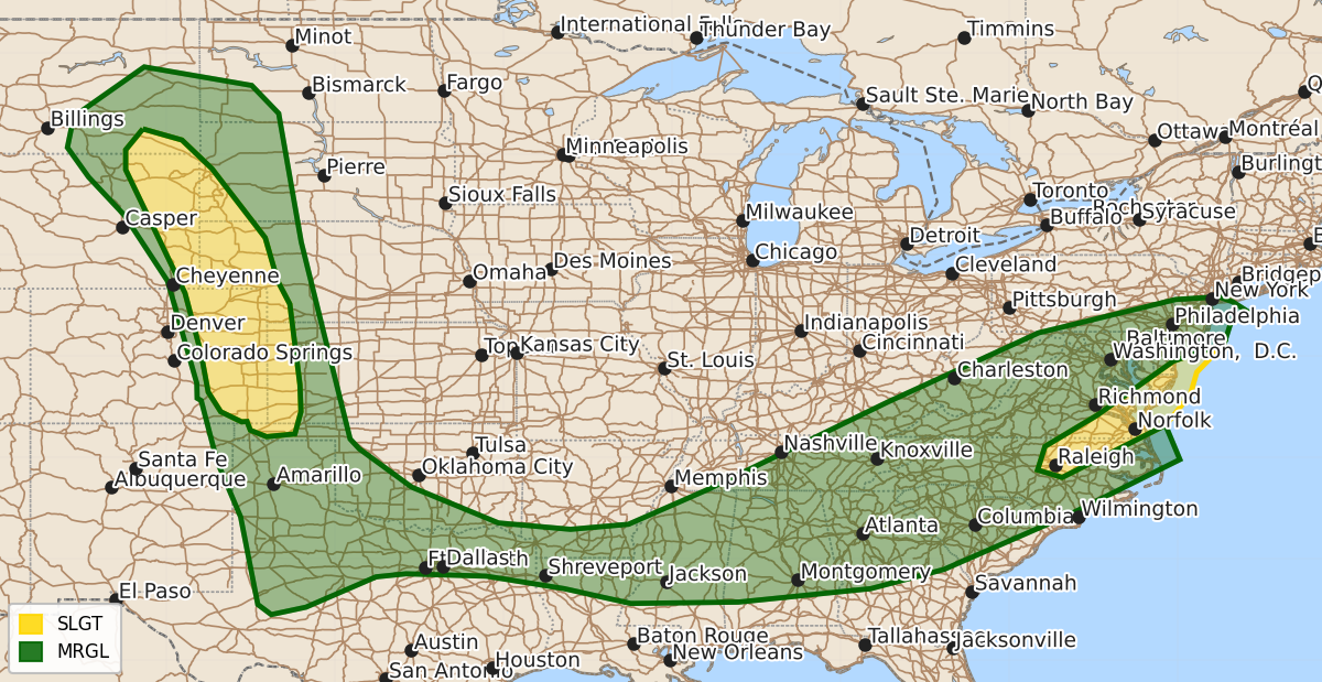
Summary
Severe thunderstorms capable of producing damaging winds, large hail, and occasional tornadoes will affect the central High Plains and Mid-Atlantic through this evening. Isolated severe storms are also expected tonight across the southern Plains and into the Middle Mississippi Valley.
Product Text
000 ACUS01 KWNS 230102 SWODY1 SPC AC 230100 Day 1 Convective Outlook NWS Storm Prediction Center Norman OK 0800 PM CDT Mon Jun 22 2026 Valid 230100Z - 231200Z ...THERE IS A SLIGHT RISK OF SEVERE THUNDERSTORMS ACROSS THE CENTRAL HIGH PLAINS AND PARTS OF THE MID ATLANTIC... ...SUMMARY... Supercells and multicell clusters will continue to produce significant-severe wind/hail across the central High Plains this evening. Severe gusts and widn damage may accompany storms near the Mid-Atlantic coast through late evening. Tonight, isolated severe storms may occur across the southern Plains into the Middle Mississippi Valley. ...Synopsis... A mid-level trough will advance toward the Mid-Atlantic Seaboard while a pronounced mid-level impulse ejects into the central/northern High Plains. At the surface, a trough will impinge on the East Coast while ongoing/developing storms continue to progress along a baroclinic boundary, from the Mid-MS Valley northwestward along the High Plains. Strong shear and buoyancy in both of these regimes will continue to foster severe potential into the evening hours. ...Mid Atlantic into the Southeast... A well defined QLCS is tracking across the Mid-Atlantic, with more sporadic pulse-cellular/multicellular storms progressing over the Southeast. The QLCS will move offshore over the next hour, accompanied by a damaging gust threat. Across the Southeast, multicellular storms supported by the remnants of daytime heating or localized lift along MCVs appear to be on the wane. Nonetheless, 1000-2000 J/kg remnant MLCAPE will support localized wet downburst potential with some of the stronger storms over the next couple of hours. A brief tornado also cannot be ruled out with MCV storms across the TN Valley. ...High Plains... Supercells remain in progress across the central to northern High Plains, where 2-3 inch in diameter hail and gusts well exceeding 75 mph have occurred. 2000+ J/kg MLCAPE, driven by 8+ C/km mid-level lapse rates, precede many of these supercells, so a severe wind/hail threat will continue with these storms for at least a few more hours. A tornado is also possible for supercells that remain inflow dominant. There is some chance that supercells could grow upscale into an MCS, which would traverse a surface boundary across the southern High Plains into the Southern Plains. Confidence in this scenario is quite low. However, should this evolution occur, severe gusts would be possible. ...Southern Plains into the Middle MS Valley... Thunderstorms are initiating along a surface boundary, draped from the TX Panhandle into central MS. 2000-4000 J/kg MLCAPE and 30-50 kts of effective bulk shear overspreads this boundary, which would promote multicells and supercells with a severe wind/hail threat wherever storms mature. Nonetheless, forcing along this boundary is weak, so the severe threat should remain isolated through tonight. ..Squitieri.. 06/23/2026 $$