Day 3 Convective Outlook
Issued: · Valid: –
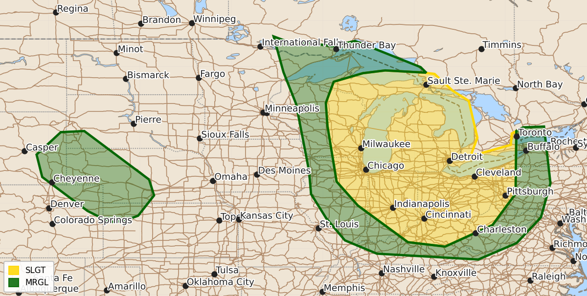
Summary
Severe thunderstorms capable of producing large hail and damaging winds are possible across the Great Lakes and Ohio Valley regions on Monday and Monday night.
Product Text
000 ACUS03 KWNS 251926 SWODY3 SPC AC 251925 Day 3 Convective Outlook NWS Storm Prediction Center Norman OK 0225 PM CDT Sat Jul 25 2026 Valid 271200Z - 281200Z ...THERE IS A SLIGHT RISK OF SEVERE THUNDERSTORMS FROM PARTS OF THE GREAT LAKES INTO THE OHIO VALLEY... ...SUMMARY... Severe storms capable of damaging winds and large hail are possible across the Great Lakes into the Ohio Valley Monday into Monday night. ...Great Lakes to Ohio Valley... A large upper ridge will hold over the Rockies and into the Plains, with a moderate northwest flow regime from the Upper MS Valley and Great Lakes into the OH Valley/Appalachians. While embedded perturbations will exist during the day, the most prominent height falls will occur Monday night over the Great Lakes. At the surface, low pressure will develop late in the day from WI into Lower MI, with a cold front pushing south overnight trailing southwestward into northern IL. A moist and unstable air mass will redevelop and push eastward across the region late in the day and overnight as 850 mb winds near 40 kt develop out of the west. Some ongoing activity may be present from Upper MI into WI, and this could either persist or strengthen during the day as the system develops southeastward. Deep-layer shear of 40-50 kt along with the strong instability could support a southward-moving MCS capable of damaging winds, perhaps with significant gusts. Will maintain current Slight Risk due to uncertainty, but higher probabilities could be needed in later outlooks. ...Eastern WY into western NE... Beneath the upper ridge, eastern low-level winds in a post frontal regime will aid westward moistening, with marginal instability. A deep mixed boundary layer will favor damaging wind gusts with activity that develops in the uncapped air mass during the late afternoon. Modest westerlies aloft and weak low-level easterlies should favor southeastward-moving storms with locally severe outflow winds. ..Jewell.. 07/25/2026 $$