Day 1 Convective Outlook
This product has been superseded. View the updated product →
Issued: · Valid: –
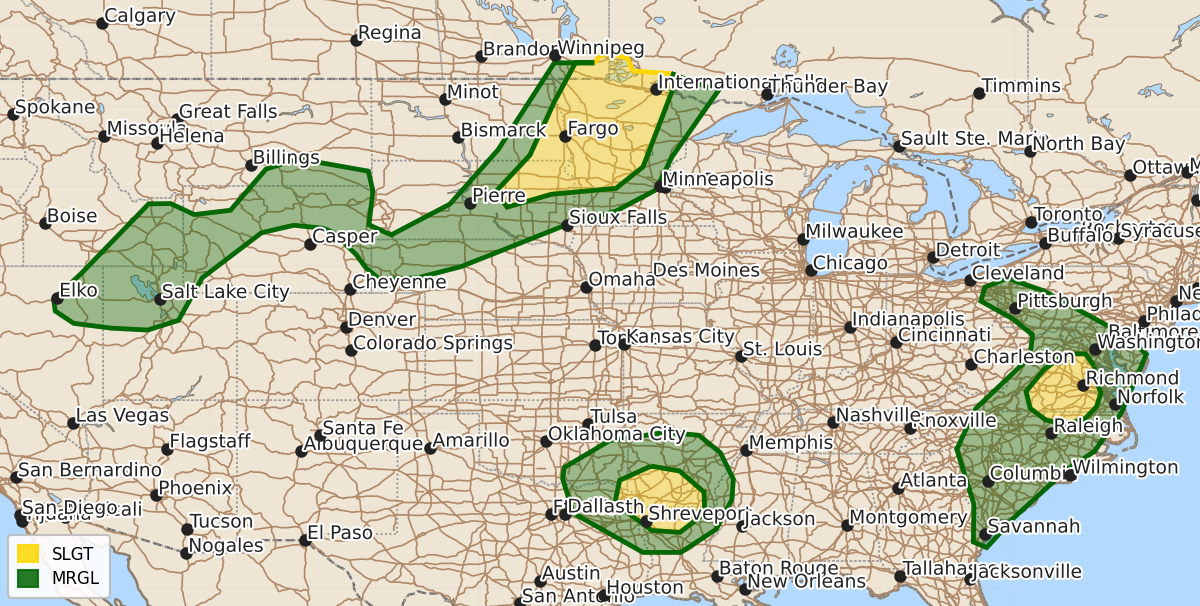
Summary
Scattered severe thunderstorms capable of large hail and damaging wind gusts are expected this afternoon and evening across the eastern Dakotas, western Minnesota, the southern Mid-Atlantic, the Carolinas, and the ArkLaTex region. Damaging wind gusts are also possible with scattered thunderstorms moving through parts of northern Utah, Wyoming, Arkansas, southeast Oklahoma, northeast Texas, and northern Louisiana today.
Product Text
000 ACUS01 KWNS 061630 SWODY1 SPC AC 061628 Day 1 Convective Outlook NWS Storm Prediction Center Norman OK 1128 AM CDT Mon Jul 06 2026 Valid 061630Z - 071200Z ...THERE IS A SLIGHT RISK OF SEVERE THUNDERSTORMS OVER PORTIONS OF THE MID-ATLANTIC...NORTHERN PLAINS...AND THE ARKLATEX REGION... ...SUMMARY... Widely scattered severe thunderstorms capable of large hail and severe wind gusts appear possible across the eastern Dakotas and western Minnesota this afternoon and evening. Isolated to scattered damaging wind gusts will also be possible with the strongest storms in the southern Mid-Atlantic, Carolinas, and ArkLaTex regions. ...MN/ND... Morning water vapory imagery shows a fast-moving shortwave trough over southern Manitoba, with its associated surface cold front sagging southward across ND. This front will serve as the focus for scattered thunderstorm development by mid-afternoon from northern MN into eastern ND. Strong heating ahead of the front and dewpoints near 70F will yield MLCAPE over 3000 J/kg. Forecast soundings show relatively steep mid-level lapse rates and favorable deep-layer shear for supercells capable of large hail and severe wind gusts. These storms may persist through the evening, spreading southward into central MN and eastern SD. ...Mid Atlantic/Carolinas... Another day of scattered afternoon thunderstorms will affect much of the Mid Atlantic and Carolinas region today. Vertical shear and steering flow is rather weak, suggesting storms will be poorly organized. However, strong heating and steep low-level lapse rates, combined with substantial CAPE in forecast soundings, suggest that the strongest cells will pose the risk of damaging wind gusts over a relatively broad area again today. ...AR/LA/OK/TX... Strong heating and ample low-level moisture will lead to scattered afternoon thunderstorms again today over much of AR, southeast OK, northeast TX, and northern LA. This is near a mid-level trough where lapse rates and mid-level temperatures are more favorable for robust up/downdrafts capable of damaging wind gusts. Have opted for a small SLGT risk for parts of this area where convective coverage appears highest. ...Northern UT into WY... Scattered high-based fast-moving thunderstorms are expected this afternoon over northern UT, moving northeastward into western and northern WY. The strongest of these cells will pose a risk of damaging wind gusts. ..Hart/Weinman.. 07/06/2026 $$