Day 1 Convective Outlook
This product has been superseded. View the updated product →
Issued: · Valid: –
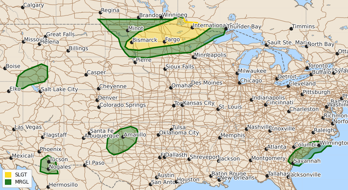
Summary
Severe thunderstorms capable of large hail, damaging winds, and tornadoes are expected across central North Dakota and northern Minnesota this afternoon and evening. Scattered thunderstorms may also bring isolated damaging wind gusts to the coastal Carolinas and parts of Idaho, Arizona, and the Texas Panhandles throughout the afternoon and evening.
Product Text
000 ACUS01 KWNS 242002 SWODY1 SPC AC 242000 Day 1 Convective Outlook NWS Storm Prediction Center Norman OK 0300 PM CDT Fri Jul 24 2026 Valid 242000Z - 251200Z ...THERE IS A SLIGHT RISK OF SEVERE THUNDERSTORMS FROM CENTRAL NORTH DAKOTA INTO NORTHERN MINNESOTA... ...SUMMARY... Severe thunderstorms capable of large to very large hail, damaging winds, and a tornado risk are expected this afternoon and evening across portions of North Dakota into northern Minnesota. ...20z Update Northern Plains/Upper Midwest... Scattered thunderstorms ongoing along a differential heating axis near the international border should continue to increase in coverage and intensity this afternoon. Aided by increasing synoptic ascent and deep-layer shear from the approaching upstream low-amplitude trough and jet, supercells and organized clusters are likely. Severe hail is expected, with some 2-3+ inches in diameter possible with the more robust supercells that evolve initially. Damaging wind gusts are also likely across eastern ND into northern MN as storms begin to grow upscale. A few significant gusts are possible given the large buoyancy and plume of steeper low-level lapse rates apparent to the southwest across ND. A couple of tornadoes are possible closer to the effective boundary, where lower temperature-dewpoint spreads and stronger low-level shear are expected. A CIG-1 wind area was included where the latest HRRR/RRFS time-lagged runs show greater clustering which could promote a sustained damaging wind or hail threat into this evening. See MCD#1622 for short-term information. ...Carolinas... Scattered thunderstorms along a weak surface cold front and sea-breeze boundary across the coast and coastal plain will continue to pose a risk for isolated damaging gusts this afternoon. 5% wind probabilities were trimmed slightly to the west where storm coverage/clustering are expected to be lower. Elsewhere, the prior forecast remains valid with no changes. Isolated severe wind gusts are possible over parts of TX, AZ and ID. See the previous discussion and active mesoscale discussions for more information. ..Lyons.. 07/24/2026 .PREV DISCUSSION... /ISSUED 1123 AM CDT Fri Jul 24 2026/ ...Dakotas/northern Minnesota... Visible-satellite imagery late this morning shows a thin stratus shield across central into northern MN ahead of a cluster of thunderstorms over southern Manitoba. This thunderstorm activity is associated with a weak mid-level vorticity max embedded within an amplifying northwest-flow pattern over the Upper Midwest. A surface trough extends southwestward into ND from a cyclone moving east along the south shore of Hudson Bay. A plume of relatively steep mid-level lapse rates will overspread a warm and moist boundary layer along/east of the surface trough, with MLCAPE increasing above 2000 J/kg across parts of North Dakota into northern Minnesota by late afternoon. Forecast model soundings show elongated hodographs thereby promoting storm organization, including supercells and eventually a small cluster or two. Morning models continue to indicate widely scattered (ND) to scattered storm development (MN) later this afternoon into the evening. Large to very large hail is possible with the supercells (1 to 3 inches in diameter). Some tornado risk will likely focus across northern MN where lower temperature-dewpoint spreads and enlarged hodographs become co-located for a few hours. Any organized clustering could result in localized corridors of greater severe-wind potential. Some severe threat could persist as storms move into a larger portion of northern/central Minnesota through late evening, with a general weakening trend expected overnight due to increasing CINH and weakening buoyancy. Farther northwest, some guidance depicts isolated supercell development west of the surface trough across the Canadian Prairies during the late afternoon, which could then move into parts of northern/central North Dakota within a northwesterly flow regime. ...Eastern ID into northeast NV... A weak disturbance evident in water-vapor imagery will continue to move northeast over northern UT into southeast ID this afternoon along the periphery of the Four Corners upper ridge. Widely scattered high-based storms will likely develop by late afternoon. Forecast soundings show inverted-V profiles supporting ample evaporative cooling with the stronger downdrafts. Isolated severe gusts 60-70 mph are possible. ...Southern High Plains vicinity... On the western periphery of residual early day precipitation/cloud cover, a nearly stationary front draped from eastern New Mexico into the Texas Panhandles is expected to become a focus for thunderstorm development by late afternoon and early evening. While deep-layer winds will be weak, strong boundary-layer heating/mixing will support potential for localized downbursts. ...Southeast AZ... Isolated to widely scattered storms are forecast to develop late this afternoon and slowly propagate westward. A couple of the stronger high-based downdrafts may yield a risk for severe gusts for a few hours before this activity dissipates by late evening. ...Coastal Carolinas... Near/south of a residual front, relatively strong heating of a moisture-rich airmass will result in the development of moderate buoyancy across the Carolina coastal plain. Scattered storm development is expected by early/mid afternoon. A couple of stronger water-loaded downdrafts may be capable of a localized wind-damage risk. $$