Day 3 Convective Outlook
Issued: · Valid: –
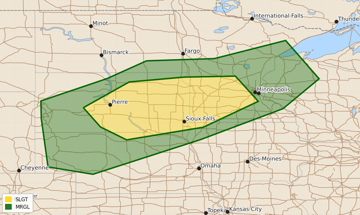
Summary
Severe thunderstorms with the potential for strong wind gusts are expected late Tuesday through Tuesday night across parts of central and eastern South Dakota and southwestern Minnesota.
Product Text
000 ACUS03 KWNS 050727 SWODY3 SPC AC 050726 Day 3 Convective Outlook NWS Storm Prediction Center Norman OK 0226 AM CDT Sun Jul 05 2026 Valid 071200Z - 081200Z ...THERE IS A SLIGHT RISK OF SEVERE THUNDERSTORMS LATE TUESDAY THROUGH TUESDAY NIGHT ACROSS PARTS OF CENTRAL AND EASTERN SOUTH DAKOTA INTO SOUTHWESTERN MINNESOTA... ...SUMMARY... An organizing cluster of thunderstorms may pose increasing potential to produce strong to severe wind gusts by late Tuesday evening into Tuesday night across parts of the middle Missouri Valley toward the Upper Midwest. ...Discussion... Models suggest that the westerlies may become a bit less progressive across the higher latitudes of North America during this period, with a deep remnant lower/mid-tropospheric cyclone only slowly migrating east-northeastward across Hudson Bay toward the northern Quebec shores. Upstream, a notable trough is forecast to only slowly pivot inland of the British Columbia coast. In advance of the trailing perturbation, a low-amplitude trough within modest zonal westerlies across the northern tier of the U.S. is forecast to progress east of the northern Rockies, and flatten initial mid-level ridging across the middle Missouri Valley by late Tuesday night. Otherwise, mid-level ridging is forecast to remain prominent along an axis from the subtropical eastern Pacific through the central and southern Great Plains, while also developing northwestward from the subtropical western Atlantic into parts of the southeast. A remnant trough or shear axis will likely linger in between, near/west through southwest of the southern Appalachians. ...Parts of the middle Missouri Valley into Upper Midwest... Latest guidance suggests that potential for stronger convective development may still remain largely influenced by sub-synoptic developments with rather low predictability at this time frame. However, there appears a consistent enough developing convective signal among the various model output to lead to some confidence in the evolution of an organized convective system across the mid Missouri Valley vicinity by late Tuesday night. It appears that stronger pre-frontal daytime heating may focus moderate to strong destabilization in a corridor roughly across south central South Dakota toward southwestern Minnesota by late Tuesday afternoon. Beneath steep lapse rates, surface dew point increases to around 70F may support mixed-layer CAPE on the order of 2000-3000+ J/kg. As remnant warm elevated mixed-layer air is suppressed further southward, the initiation of storms capable of producing severe hail and wind seems probable by early Tuesday evening. It is possible that the most substantive upscale growth, intensification and organization awaits forcing associated with a nocturnal strengthening low-level jet toward late evening. But, as this occurs, the environment appears potentially conducive to the development of a swath of damaging winds as it propagates east-southeastward Tuesday night. ..Kerr.. 07/05/2026 $$