Day 1 Convective Outlook
This product has been superseded. View the updated product →
Issued: · Valid: –
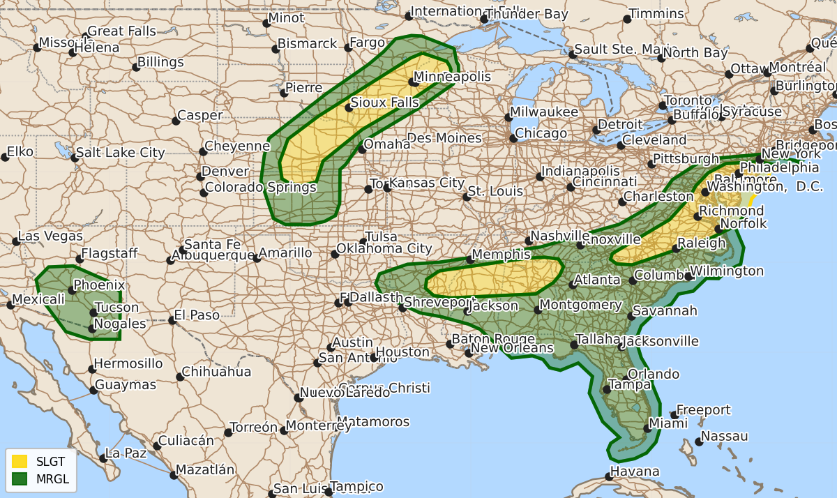
Summary
Scattered severe thunderstorms are expected this afternoon and evening across parts of the Mid-Atlantic, Southeast, and the central Plains into the Upper Mississippi Valley. Hazards may include tornadoes, large hail, and damaging wind gusts.
Product Text
000 ACUS01 KWNS 201635 SWODY1 SPC AC 201633 Day 1 Convective Outlook NWS Storm Prediction Center Norman OK 1133 AM CDT Thu Aug 20 2026 Valid 201630Z - 211200Z ...THERE IS A SLIGHT RISK OF SEVERE THUNDERSTORMS ACROSS PORTIONS OF THE MID-ATLANTIC...PARTS OF THE SOUTHEAST...AND FROM THE CENTRAL PLAINS INTO THE UPPER MISSISSIPPI VALLEY... ...SUMMARY... Scattered severe storms are possible this afternoon into this evening across parts of the Mid Atlantic, posing a risk for a couple of tornadoes and damaging wind gusts. Large hail and isolated wind damage will be possible late today into tonight with severe storms from Nebraska into northwest Wisconsin. Scattered damaging gusts are possible over parts of the Deep South this afternoon into the early evening. ...Central Appalachians into the Mid-Atlantic... Radar mosaic late this morning showed a couple of weak convectively related vorticity maxima moving east across the central and southern Appalachians (i.e., southwest PA, eastern KY). One of these lead disturbances was sampled by the WSR-88D VAD at Jackson, KY, with an upstream shortwave trough over the OH Valley moving towards the Mid-Atlantic states. The airmass across the Mid-Atlantic into the Carolinas will continue to heat amid patchy but thinning cloud cover. Model guidance shows moderate buoyancy developing by early to mid afternoon from the southern Appalachians northward into the northern Mid-Atlantic region. A belt of stronger 700-500 mb westerly flow (30-45 kt) will overspread the northern half of VA northward into PA/NJ. Beneath this stronger flow, southerly low-level flow veering and strengthening with height will support hodographs favorable for organized severe storms, including supercells and organized line segments. The latest model guidance shows a few simulated supercells developing in the area centered over MD and the upper Chesapeake Bay vicinity during the 20-00z timeframe. This scenario seems plausible given some low-level enlargement to the hodograph and effective shear around 40 kt. A tendency for upscale growth into a line segment is expected as this activity moves east towards the coast during the evening. A couple of supercell tornadoes are possible with this activity, in addition to a line-embedded mesovortex and scattered damaging gusts. ...Carolinas into the TN Valley and lower MS Valley... Ample low-level moisture and strong heating will result in an unstable airmass from the Carolinas into much of the Southeast. Low-level convergence along a cold front that will extend from the western Carolinas into AR this afternoon will result in scattered thunderstorm coverage as 2500-4000 J/kg MLCAPE develops by mid afternoon. High PW (in excess of 2 inches) and steep 0-3 km lapse rates and modest westerly to west-northwesterly flow will favor damaging downbursts with the stronger southeast-moving clusters. ...Central Plains into the Upper MS Valley... A tongue of relatively rich low-level moisture (mainly 60s F surface dewpoints) will extend from the central Great Plains northward ahead of a cold front, which is forecast to be draped from western MN into western NE this afternoon. Thunderstorm initiation is anticipated first across the Upper MS Valley before expanding southwestward. Moderate northwesterly flow aloft will support supercell wind profiles, with elongated/straight hodographs, and the threat for all severe hazards. Large to very large hail (i.e. greater than 2 inch diameter) will be the primary severe hazard, particularly during the early evening as the storms move into greater instability. Isolated strong to severe gusts (i.e. 55 to 75 mph) are possible as well. Given the supercellular storm mode and low-level southerly flow, a low-probability tornado risk also exists. Some risk for isolated damaging gusts may persist into the early overnight across southern NE and northern KS if clustering can occur. ...AZ... Not much change from prior forecast thinking in that isolated to widely scattered storms are forecast but a generally lower risk for severe gusts is anticipated later today into this evening. Steep lapse rates and inverted-V profiles will support an isolated risk for severe gusts with the more intense downdrafts. ..Smith/Wendt.. 08/20/2026 $$