Day 3 Convective Outlook
Issued: · Valid: –
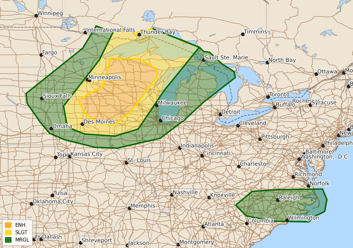
Summary
Severe thunderstorms are expected across portions of the Upper Midwest and Great Lakes on Monday, primarily bringing the threat of damaging winds and isolated large hail. Additionally, isolated strong winds may occur in parts of the Carolinas during Monday afternoon.
Product Text
000 ACUS03 KWNS 181935 SWODY3 SPC AC 181934 Day 3 Convective Outlook NWS Storm Prediction Center Norman OK 0234 PM CDT Sat Jul 18 2026 Valid 201200Z - 211200Z ...THERE IS AN ENHANCED RISK OF SEVERE THUNDERSTORMS OVER PARTS OF THE UPPER MIDWEST AND GREAT LAKES... ...SUMMARY... Severe thunderstorms are probable across portions of the Upper Midwest and Great Lakes vicinity on Monday. Swaths of damaging winds will be the most likely hazard, with isolated large hail as well. Isolated strong to damaging gusts may occur over parts of the Carolinas. ...From Lake Superior to Iowa... A strong shortwave trough will move southeastward across the northern Plains and upper MS Valley on Monday, with 50-60 kt 500 mb winds across MN/IA/WI enhancing deep-layer shear. Early day storms may occur within the warm advection regime, with at least some threat of severe wind or hail. This activity may weaken during the day and give way to diurnal destabilization, with areas of strong instability developing. Notably, mid to high level winds will be quite strong, with highly elongated hodographs favoring both supercells and severe bows. Corridors of significant wind will be possible, with some models indicating a bimodal distribution (northern WI, and IA). However, the environment across the entire area ahead of cold front will conditionally support severe storms. Despite some uncertainties, the synoptically evident upper wave and ample instability support an upgrade to Enhanced Risk. ...North Carolina... A weak surface low will develop over NC with strong daytime heating beneath modest northwest flow aloft. Mid 70s F dewpoints will contribute to MLCAPE over 2000 J/kg, with clusters of storms developing during the afternoon. Multicellular clusters appear likely, moving generally eastward with potential for locally damaging outflow winds. ..Jewell.. 07/18/2026 $$