Day 2 Convective Outlook
Issued: · Valid: –
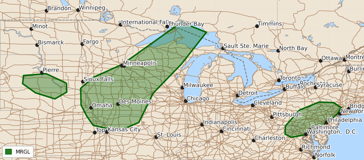
Summary
Marginal severe thunderstorms with potential for damaging winds and hail are expected Friday across parts of the Mid-Missouri Valley, Wisconsin, Upper Michigan, the Northeast, and parts of Nebraska and South Dakota. Additional storms capable of producing hail or wind damage may develop late Friday night into early Saturday morning across central Nebraska and South Dakota.
Product Text
000 ACUS02 KWNS 061735 SWODY2 SPC AC 061734 Day 2 Convective Outlook NWS Storm Prediction Center Norman OK 1234 PM CDT Thu Aug 06 2026 Valid 071200Z - 081200Z ...THERE IS A MARGINAL RISK OF SEVERE THUNDERSTORMS IN PARTS OF THE MID-MISSOURI VALLEY INTO WISCONSIN AND THE UPPER PENINSULA OF MICHIGAN...PARTS OF THE NORTHERN MID-ATLANTIC...SOUTH-CENTRAL SOUTH DAKOTA INTO NORTH-CENTRAL NEBRASKA... ...SUMMARY... A few strong to severe storms may occur from the Mid-Missouri Valley across Wisconsin and into Upper Michigan Friday, with areas of strong/damaging wind gusts and isolated marginal hail. Other storms may produce locally damaging gusts over parts of the Northeast and hail over parts of central Nebraska/South Dakota. ...Mid-Missouri Valley into Wisconsin/Upper Peninsular Michigan... A cold front will move into the Upper Midwest during the afternoon. Moisture return ahead of the front will maintain upper 60s F farther north to low 70s F dewpoints across Iowa/southern Minnesota. 2000-3000 J/kg MLCAPE is expected during the afternoon. The approaching mid-level jet will bring stronger mid-level flow and 30-45 kt of effective shear to the region (stronger shear will generally exist with southwestward extent). Initial activity will likely be cellular with a tendency to become more linear with time. Large hail and damaging winds will be the main concerns. Given the stronger buoyancy and shear within Iowa, there is greater potential for an MCS to develop with an associated greater risk for wind damage. Variance is relatively high within model guidance as to where this corridor will exist due in part to the subtle forcing. Some guidance suggests a cluster of activity is possible during the morning hours. This could intensify as the airmass destabilizes during the day. Other guidance suggests limited morning activity with storms forming along the front farther east. An increase in wind probabilities is possible as confidence increases. ...South Dakota/Nebraska... At least moderate elevated instability is forecast to develop as a low-level jet intensifies within the region late Friday night into early Saturday morning. Several CAMs and global guidance suggest development will occur. Sufficient mid-level flow on the southern flank of the northern Plains trough will allow for organized storms. Steep mid-level lapse rates will support a risk for isolated large hail. ...Northern Mid-Atlantic... Though mid-level winds will be slightly weaker than on Thursday, the approach of a modest trough will allow for marginally organized storms within a very moist environment. Afternoon MLCAPE will near 2000 J/kg in parts of the Mid-Atlantic. Model consensus continues to support the potential for widely scattered to scattered storms within this weakly capped airmass. Isolated damaging winds will be possible. ...Southern Plains into the Ozarks... Given the presence of a stalled boundary/outflow, some potential exists for storms to develop during the afternoon. Confidence on where this boundary will be placed is quite low at this time. Deep-layer shear will also be somewhat weak as well. Given these factors, severe wind probabilities will be withheld, though isolated wind damage could occur. ..Wendt.. 08/06/2026 $$