Day 2 Convective Outlook
Issued: · Valid: –
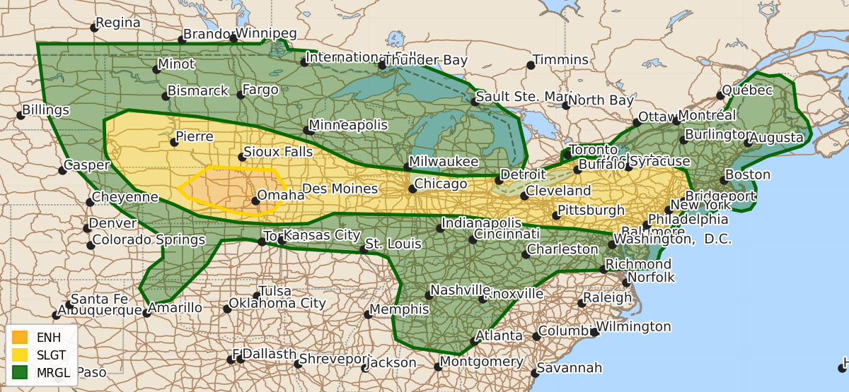
Summary
Severe thunderstorms capable of producing large hail and damaging winds are expected Friday across parts of Nebraska and Iowa, with additional isolated severe storms possible across the Midwest, Tennessee Valley, and Mid-Atlantic.
Product Text
000 ACUS02 KWNS 021719 SWODY2 SPC AC 021717 Day 2 Convective Outlook NWS Storm Prediction Center Norman OK 1217 PM CDT Thu Jul 02 2026 Valid 031200Z - 041200Z ...THERE IS AN ENHANCED RISK OF SEVERE THUNDERSTORMS FROM CENTRAL NEBRASKA INTO WESTERN IOWA... ...SUMMARY... Scattered wind damage and large hail are expected from parts of Nebraska into Iowa Friday. Isolated to scattered severe storms are also possible extending eastward from the northern/central Plains into the Midwest, Tennessee Valley, and Mid-Atlantic. ...Synopsis... An upper high will remain over the Appalachians and Carolinas, with a somewhat weaker ridge aloft extending westward into the southern Rockies. Relatively cool midlevel temperatures will generally stretch from the northern Plains and across much of the Great Lakes an Northeast, as modest mid and high level westerlies persist. In the low levels, substantial moisture and instability will persist across those same areas, as south to southwest surface winds maintain 70s F dewpoints around the northern periphery of a southeast U.S. surface high. An east-west oriented boundary will stretch from the northern Plains eastward across the Great Lakes region, with various clusters of thunderstorms throughout the period within this unstable zone. ...Northern/Central Plains... Any outflows from overnight convection are likely to mix, with strong instability developing. Cells will form over the northern High Plains initially with localized hail and wind. Larger coverage of storms will occur from southern SD into northern NE during the mid/late afternoon, with general upscale growth into one or more MCSs. However, supercells may occur initially with large hail and a brief tornado. Supporting a severe MCS will be ample precipitable water, strong instability, and an increasing southerly low-level jet during the evening. Additional isolated hail or wind may occur near the surface trough into western KS and toward the TX Panhandle where temperatures will be hot. ...Much of the Midwest to the Lower Great Lakes and across NY, PA and NJ... The entire corridor stretching from northern IL/southern WI into NY and NJ will destabilize with daytime heating and robust moisture. Storms are most likely from WI/IL during the late afternoon, and also near the Lower Great Lakes, affecting OH, PA, NY. Modest westerlies aloft and the uncapped air mass across the area will support a few longer-lived clusters of storms capable of damaging wind gusts. Some of the activity may proceed into western New England into early evening. ...TN Valley and northern GA... Within the weak easterly flow regime aloft, just south of the upper ridge, storms are expected to form during the afternoon with the very moist and unstable air mass. Mid 70s F dewpoints will again lead to strong instability, with multicell clusters moving west/northwest by mid/early afternoon. Locally damaging wind gusts are possible. ..Jewell.. 07/02/2026 $$