Day 3 Convective Outlook
Issued: · Valid: –
Summary
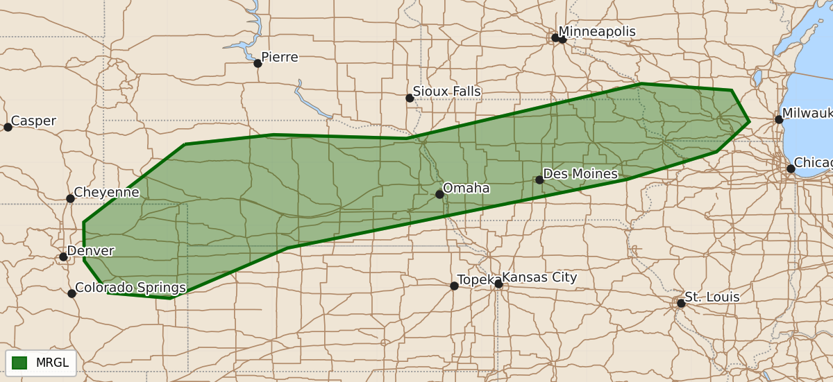
Isolated severe thunderstorms capable of producing wind and hail are possible Monday afternoon from the central High Plains toward parts of the Corn Belt.
Product Text
000 ACUS03 KWNS 291935 SWODY3 SPC AC 291934 Day 3 Convective Outlook NWS Storm Prediction Center Norman OK 0234 PM CDT Sat Aug 29 2026 Valid 311200Z - 011200Z ...THERE IS A MARGINAL RISK OF SEVERE THUNDERSTORMS FROM THE CENTRAL HIGH PLAINS TO PARTS OF THE CORN BELT... ...SUMMARY... Isolated severe thunderstorms, accompanied by wind and hail, are possible Monday afternoon from the central High Plains toward parts of the Corn Belt. ...Discussion... On Monday, a shortwave trough will lift northeastward out of the Northern Plains, with an upper high over the Mid MS/Lower OH Valleys. To the west, an upper low will drop southward off the West Coast, with increasing southwest flow aloft from CA into the Great Basin late. A leading wave is also forecast to develop over the central Rockies, moving from CO into NE overnight. At the surface, a quasi-stationary boundary will extend from NE/SD into southern MN/WI, where 60s to 70s F dewpoints will exist. Conditionally, this region could support a severe risk. However, the departing upper wave combined veering and weakening low-level winds suggest minimal storm coverage for most of the period. Some forecast soundings also indicate shallow boundary layer moisture. However, isolated storms cannot be ruled out both during the day and overnight within this moist zone, therefore will maintain low severe probabilities. Scattered strong to severe storms may also occur over the Central High Plains, where a lee trough will develop and where a developing midlevel wave is forecast. Strong heating as well as 50s to near 60 F dewpoints will support scattered late afternoon storms from eastern CO/southeast WY, spreading northeast into NE. A few severe gusts or marginal hail will be possible. ..Jewell.. 08/29/2026 $$