Day 2 Convective Outlook
Issued: · Valid: –
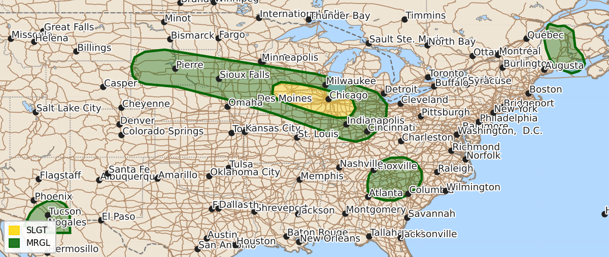
Summary
Severe thunderstorms capable of producing damaging wind gusts are possible Sunday afternoon and evening across parts of the northern Plains, the southern Great Lakes, Maine, the southern Appalachians, and southeast Arizona. These storms are expected to vary in severity, with the potential for intense wind segments in the Midwest and isolated wind damage in the other affected regions.
Product Text
000 ACUS02 KWNS 080632 SWODY2 SPC AC 080630 Day 2 Convective Outlook CORR 1 NWS Storm Prediction Center Norman OK 0130 AM CDT Sat Aug 08 2026 Valid 091200Z - 101200Z ...THERE IS A SLIGHT RISK OF SEVERE THUNDERSTORMS ACROSS PARTS OF THE MIDWEST... CORRECTED FOR THUNDERLINE ...SUMMARY... Thunderstorms with severe wind gusts will be possible Sunday afternoon and evening from parts of the northern Plains east-southeastward into the southern Great Lakes. Severe gusts will also be possible in parts of the southern Appalachians, Maine and southeast Arizona. ...Northern Plains/Mid To Upper Mississippi Valley/Southern Great Lakes... Mid-level flow will be west-northwesterly on Sunday from the northern Plains into the Great Lakes. At the surface, a moist and unstable airmass will be in place from South Dakota eastward into the southern Great Lakes. Although moderate instability is forecast to develop over much of this corridor by afternoon, large-scale ascent will remain relatively weak. For that reason, thunderstorm development will confined to areas where low-level convergence becomes maximized. Some solutions show an east-to-west axis of strong low-level convergence from Iowa into northern Indiana, suggesting this could be a favored area for thunderstorm development in the afternoon and evening. Forecast soundings near this axis in the late afternoon have surface dewpoints in the 70s with moderate to strong instability. 0-6 km shear is forecast to be in the 35 to 45 knot range with a substantial amount of low-level directional shear. This should support a severe threat with supercells and short intense line segments. Severe wind gusts will be the primary threat. Further west into parts of the northern Plains, a subtle shortwave trough is forecast to move into South Dakota during the day. A post-frontal airmass will be in place ahead of the shortwave with surface dewpoints in the 60s to near 70 F. This will contribute to moderate instability by afternoon. Thunderstorms that develop near the axis of instability will have potential for isolated severe gusts during the late afternoon and early evening. ...Maine... A mid-level shortwave trough is forecast to move across the Great Lakes on Sunday, with west-southwesterly flow located over the Northeast. Ahead of the system, a cold front is forecast to move eastward across New England. As surface temperatures warm during the day, thunderstorm development is expected to take place near the front in the higher terrain across parts of western Maine. These storms are forecast to move quickly eastward across central and eastern Maine during the afternoon. Moderate instability, steep low lapse rates and sufficient deep-layer shear will likely support an isolated wind-damage threat. ...Southern Appalachians... Moderate instability will develop on Sunday across much of the southern Appalachians, where surface dewpoints will be in the upper 60s to mid 70s F. As surface temperatures warm during the day, scattered thunderstorms will develop in the higher terrain. The moderate instability, along with precipitable water values in the 1.70 to 1.85 inch range, will support a potential for isolated severe wet downbursts as instability becomes maximized in the late afternoon. ...Southeast Arizona... Surface dewpoints across southern Arizona will be in the upper 50s to near 60 F on Sunday. As surface temperatures warm during the day, moderate instability will develop over much of southern Arizona. Thunderstorms are expected to form in the higher terrain of eastern Arizona, with the storms moving west-southwestward into the unstable air during the late afternoon and early evening. Steep low-level lapse rates and large surface temperature-dewpoint spreads will support an isolated wind-damage threat. ..Broyles.. 08/08/2026 $$