Day 1 Convective Outlook
This product has been superseded. View the updated product →
Issued: · Valid: –
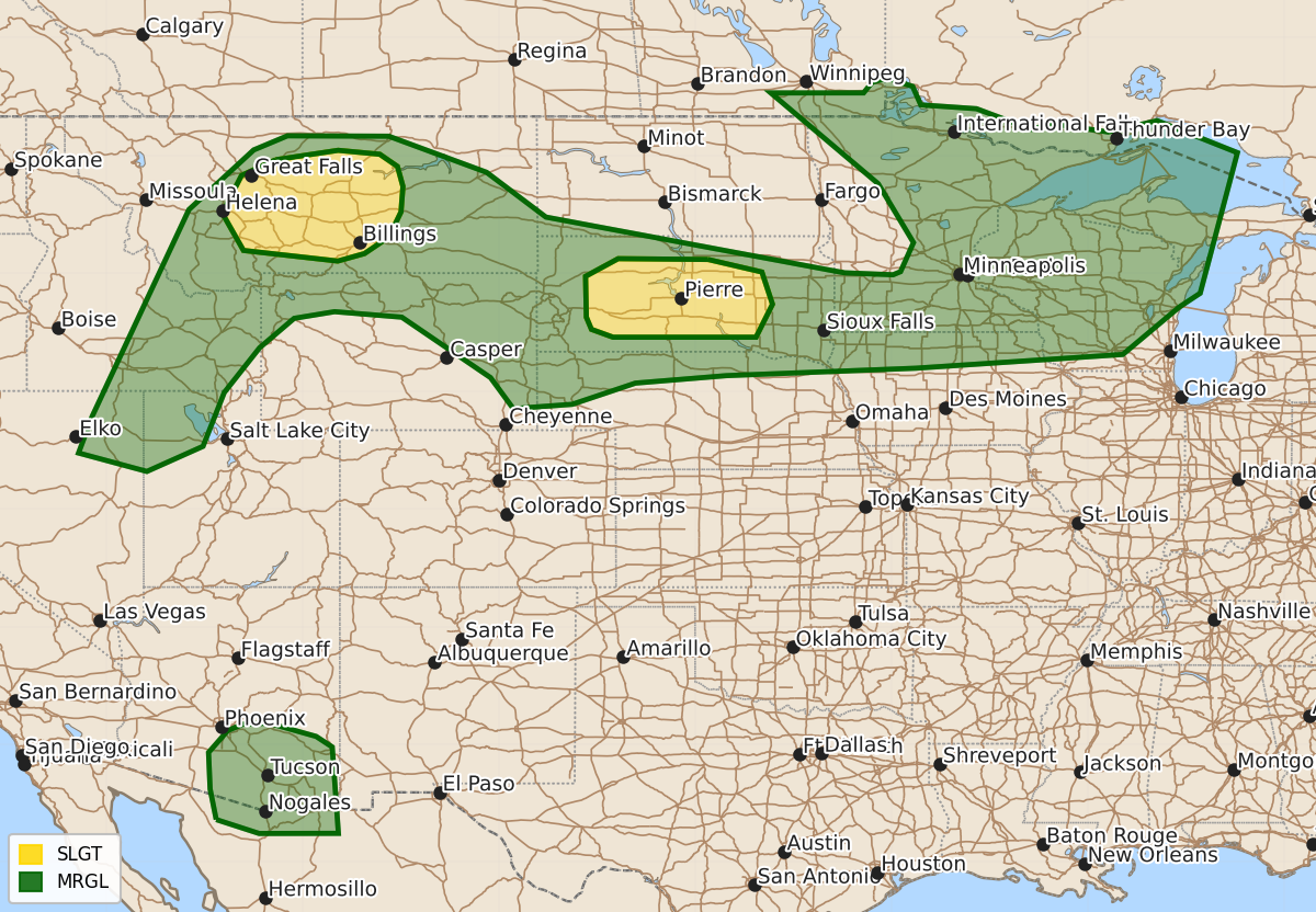
Summary
Scattered severe thunderstorms capable of producing damaging wind gusts of 75 mph or higher are possible across parts of central Montana and South Dakota this afternoon and evening. Isolated severe storms with potential for wind, hail, or tornadoes may also develop in the Upper Midwest late this afternoon or tonight.
Product Text
000 ACUS01 KWNS 250558 SWODY1 SPC AC 250556 Day 1 Convective Outlook NWS Storm Prediction Center Norman OK 1256 AM CDT Sat Jul 25 2026 Valid 251200Z - 261200Z ...THERE IS A SLIGHT RISK OF SEVERE THUNDERSTORMS FOR PARTS OF CENTRAL MT...AND ALSO ACROSS PARTS OF SD... ...SUMMARY... Storms with scattered severe wind gusts are possible across parts of Montana and South Dakota this afternoon and evening. ...MT into SD and vicinity... An expansive upper ridge will remain anchored over much of the southwest and central CONUS through the period. Very hot temperatures are expected this afternoon from MT into the Dakotas. Isolated to scattered storms within the hot and well-mixed environment will result in a broad area of at least isolated severe-wind potential. 5% wind probabilities have been expanded to cover this potential, with 15% wind probabilities (equivalent to categorical Level 2/Slight Risk) added across parts of MT and SD, where terrain features may enhance storm coverage within the favorable severe-wind environment. For parts of western/central MT, convection that develops by early/mid afternoon near the high terrain is expected to spread eastward into the hot and well-mixed environment. This convection may be aided by a low-amplitude midlevel vorticity maximum moving around the periphery of the upper ridge. Increasing storm coverage and gradually strengthening mid/upper-level flow may allow for one or more outflow-driven clusters to develop and spread east-northeastward into early evening, with a threat of severe gusts. Localized gusts of 75+ mph cannot be ruled out, especially if deeper convection is able to spread into areas where very deep mixing and heating to near/above 100 F occurs prior to storm arrival. Farther east, very strong heating is expected across parts of western/central SD, with temperatures in some areas potentially rising to near/above 105 F. Low-level moisture will be relatively sparse, but MLCAPE of near/above 1000 J/kg will be possible where 50s F dewpoints can be maintained within the well-mixed environment. Initial storm development near the Black Hills will quickly become outflow dominant as it spreads eastward, with an increasing threat of severe gusts. Deep-layer shear will be somewhat favorable for organized convection, and some guidance depicts development of a persistent cluster or loosely organized MCS that moves eastward across SD along a weak surface boundary. Should this occur, a corridor of more organized severe-wind threat (with gusts potentially near/above 75 mph) will be possible. ...Northern/eastern MN into WI and Upper MI... Conditional severe potential remains evident across parts of the Upper Midwest, though confidence regarding storm coverage and timing remains very low within the weakly forced environment. Moderate to strong destabilization is possible along/south of a surface front that is forecast to extend from northeast ND into northern MN/WI by late afternoon. Effective shear of 50+ kt will be more than sufficient for storm organization, but most guidance remains rather muted regarding potential for diurnal storm development. If storms are able to develop during the afternoon or evening, then a threat for hail, damaging wind, and possibly a tornado could evolve. Even if diurnal storm development is limited, vigorous elevated storms may evolve within a warm-advection regime near/north of the front late tonight, which would pose a threat for hail and perhaps locally damaging wind. Confidence remains too low to include more than Level-1/Marginal Risk equivalent probabilities at this time. ...Northeast NV/northern UT into eastern ID... Storm development is expected during the afternoon across parts of northeast NV, along the western periphery of the upper ridge. These storms will spread into adjacent parts of southeast ID and northwest UT with time. Strong to locally severe gusts will be possible with these storms as they move northeastward through a well-mixed environment. ...South-central/southeast AZ... High-based convection is again expected across southeast AZ during the afternoon, with initial downburst potential. Modest enhancement to easterly flow along the southern periphery of the upper ridge may allow for localized strong to severe gusts to spread westward into parts of south-central AZ, before convection weakens later Saturday night. ..Dean/Squitieri.. 07/25/2026 $$