Day 2 Convective Outlook
Issued: · Valid: –
Summary
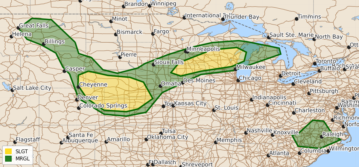
Strong thunderstorms capable of producing severe hail and wind may develop across parts of the Upper Midwest and central Great Plains on Wednesday afternoon into Wednesday night. Some areas may also experience damaging wind gusts in the southern Mid-Atlantic during Wednesday evening.
Product Text
000 ACUS02 KWNS 070532 SWODY2 SPC AC 070530 Day 2 Convective Outlook NWS Storm Prediction Center Norman OK 1230 AM CDT Tue Jul 07 2026 Valid 081200Z - 091200Z ...THERE IS A SLIGHT RISK OF SEVERE THUNDERSTORMS WEDNESDAY AFTERNOON INTO WEDNESDAY NIGHT ACROSS PARTS OF THE CENTRAL GREAT PLAINS AND UPPER MIDWEST... ...SUMMARY... Clusters of strong thunderstorms with potential to produce severe hail and wind may evolve across parts of the Upper Midwest into central Great Plains Wednesday through Wednesday night. ...Discussion... While a blocking, but perhaps weakening, mid-level high lingers in the north central Canadian Arctic latitudes, it appears that one still fairly vigorous short wave trough and embedded low will begin to dig southeast of the Hudson Bay vicinity Wednesday through Wednesday night, while an upstream short wave trough pivots across the Canadian Rockies, then northward toward the Northwest Territories. In association with these developments, within a belt of modest westerlies closer to and south of the international border, subtle mid-level ridging may overspread the northern Rockies, with similar amplitude downstream troughing digging across the northern Great Plains, Upper Midwest and Great Lakes region. Beneath this regime, a weak cold front, perhaps reinforced by convective outflow in some locations, is forecast to overspread much of the remainder of the Upper Midwest/adjacent Great Lakes and middle Missouri Valley vicinity by late Wednesday night. This may be preceded across parts of the central Great Plains by conglomerate convective outflow emanating from considerable thunderstorm development spreading off the Laramie Range/Front Range vicinity, within weak west-northwesterly steering flow. In the southern mid- to subtropical latitudes, modest mid-level ridging is forecast to generally prevail, but weak remnant troughing may slowly migrate from the Mid South toward the southern Appalachians, along its northern periphery. ...Upper Midwest... Steeper mid-level lapse rates associated with a remnant plume of elevated mixed-layer air may become increasingly confined to the higher plains during this period. However, seasonably high moisture content along/ahead of the southward advancing cold front may still become supportive of mixed-layer CAPE of 1500-2000+ J/kg with daytime heating. Based on latest guidance, it is appearing less probable that a cluster of strong continuing thunderstorm development, with a possible MCV, will be substantively maintained into this period across parts of the Upper Midwest into adjacent Great Lakes region. But, this remains uncertain. There appears a stronger signal for renewed thunderstorm development within the corridor of pre-frontal destabilization trailing to the southwest, across central into southern Wisconsin, southeastern Minnesota and northeastern Iowa by late Wednesday afternoon, aided by forcing for ascent with the digging mid-level troughing. It is possible that a belt of convectively augmented westerly mid-level flow, including 30+ kt around 700 mb, contributes to sufficient shear for evolving supercell structures. These may pose a risk for severe hail, and perhaps some potential for a tornado or two, before damaging wind gusts become more prominent prior to storm weakening Wednesday evening. ...Central Great Plains... By late Wednesday afternoon or early evening, it appears that boundary-layer destabilization associated with moistening easterly low-level flow may support intensification of initially scattered thunderstorm development off the Laramie Mountains through Colorado Front Range. Pronounced veering of wind fields with height may yield sufficient shear for supercells posing a risk for severe hail and wind. There remains a fairly notable signal that forcing associated with a nocturnally strengthening low-level jet, and perhaps a subtle digging mid-level perturbation, may contribute to an upscale growing and organizing cluster with potential to produce more widespread strong to severe wind gusts Wednesday evening into Wednesday night. ...Parts of the southern Mid Atlantic... Thermodynamic profiles may again become conducive to locally strong downbursts in convection likely to develop off the Blue Ridge Mountains, and within surface troughing to the north and northeast of a weak developing lee surface low. Aided by forcing for ascent associated with weak low-level warm advection and convergence, an upscale growing cluster, with potential to produce potentially damaging wind gusts along the leading edge of consolidating outflow, could overspread the North Carolina Piedmont by Wednesday evening. ..Kerr.. 07/07/2026 $$