Day 3 Convective Outlook
Issued: · Valid: –
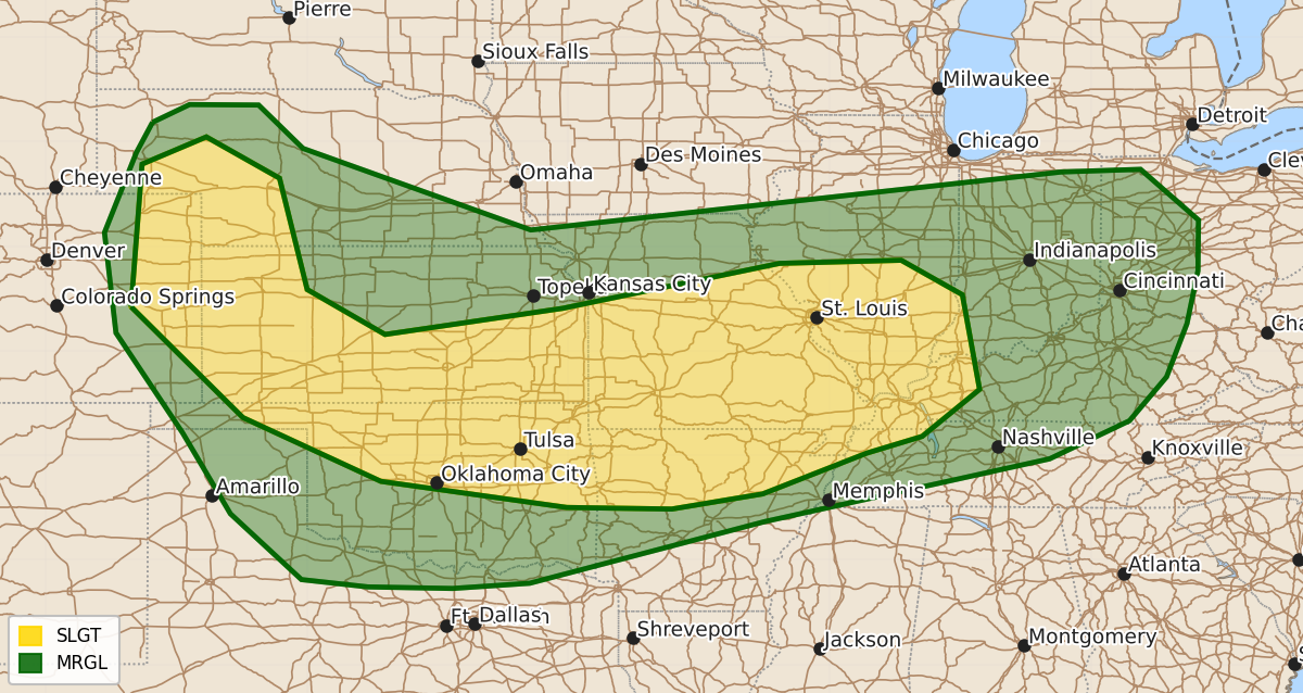
Summary
Severe thunderstorms capable of producing large hail, damaging winds, and tornadoes are possible across the central High Plains, Mid-Mississippi Valley, and parts of the Ohio Valley on Sunday. The timing of these storms will vary, with some activity occurring in the morning and other portions expected throughout the afternoon and evening.
Product Text
000 ACUS03 KWNS 191934 SWODY3 SPC AC 191933 Day 3 Convective Outlook NWS Storm Prediction Center Norman OK 0233 PM CDT Fri Jun 19 2026 Valid 211200Z - 221200Z ...THERE IS A SLIGHT RISK OF SEVERE THUNDERSTORMS FROM THE CENTRAL HIGH PLAINS INTO THE MID-MISSISSIPPI/LOWER OHIO VALLEYS... ...SUMMARY... Severe storms are possible along a frontal zone from the Mid-Mississippi Valley to the central High Plains on Sunday. Large hail, severe winds, and tornadoes will be possible. ...Mid-Mississippi Valley... Models indicated that convection will likely be ongoing during the morning in portions of Missouri and will move into central/southern Illinois. The degree of airmass recover behind this activity is not certain. There will certainly be a corridor of greater severe potential along the trailing outflow from central Missouri into southern Illinois, but confidence in such a scenario remains low at this point. Furthermore, upper-level flow is not going to be overly strong and any supercells that can develop may struggle to maintain intensity. Even so, the potential for large hail, severe winds, and tornadoes is evident. ...Central High Plains... Lingering moisture behind the weak surface front and upslope flow during the afternoon will promote thunderstorm development within eastern Colorado. A belt of stronger westerly flow will bring effective shear of around 45 kt. Steep mid-level lapse rates and long hodographs suggest potential for large to very-large (up to 2 in.) hail will be possible along with isolated severe gusts. Activity may not move very far east given increasing MLCIN farther into western Kansas. ...Kansas/Oklahoma/Ozarks... Heating of a moist airmass south of the surface boundary will promote strong buoyancy (perhaps 3000-4000 J/kg MLCAPE). As the shortwave trough continues east, the cold front will begin to move southward by the evening. The low-level jet will strengthen and provide additional lift along the boundary. A line of thunderstorms is expected to move southward. Damaging winds are the main hazard with this activity. ...Middle Ohio Valley Vicinity... Convection that will move through Missouri/Illinois in the morning may continue eastward. Given the modest surface low expected to develop, some airmass destabilization is possible into Indiana/Ohio. Strong low-level wind fields would support a risk for damaging winds and perhaps a tornado or two. ..Wendt.. 06/19/2026 $$