Day 1 Convective Outlook
This product has been superseded. View the updated product →
Issued: · Valid: –
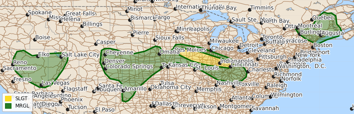
Summary
Isolated to scattered severe thunderstorms capable of damaging wind gusts and hail are possible today across parts of the Midwest, the southern and central High Plains, the Great Basin, and the Northeast. These storms may continue into tonight for portions of the Midwest, including eastern Iowa and Illinois and Indiana.
Product Text
000 ACUS01 KWNS 131634 SWODY1 SPC AC 131632 Day 1 Convective Outlook NWS Storm Prediction Center Norman OK 1132 AM CDT Thu Aug 13 2026 Valid 131630Z - 141200Z ...THERE IS A SLIGHT RISK OF SEVERE THUNDERSTORMS ACROSS PARTS OF THE MIDWEST... ...SUMMARY... Isolated to scattered severe thunderstorms are possible today from parts of the southern/central High Plains to the Midwest. Severe wind gusts should be the main threat, but some hail may also occur. ...Midwest including parts of eastern Iowa and Illinois/Indiana... Supported by an MCV, a long-lived MCS continues to move east-southeastward into west-central/northwest Illinois late this morning. Greater stability initially precedes the MCS across northern Illinois, but the remnant cluster and additional redevelopment will likely tend to favor a more southeastward progression in closer proximity to the front/instability gradient that extends across Illinois/Indiana, with additional/renewed development and intensification possible into the afternoon and evening. Damaging wind gusts will be the primary severe hazard, although a brief tornado and marginally severe hail are also possible into this evening. While not certain, additional severe redevelopment may also occur tonight farther west/northeastward across areas potentially including eastern Iowa and northern/central Illinois as a low-level jet nocturnally increases. ...Southern/Central High Plains... High-based thunderstorms are expected to initially develop over the higher terrain of the central Rockies/Front Range this afternoon, with post-frontal low-level upslope flow persisting across the central High Plains. Storm motions into slightly richer moisture will favor some aggregation of outflow within a hot boundary layer featuring steep lapse rates. Isolated to widely scattered severe wind gusts 60-75 mph are possible, along with occasional hail with a few of the stronger cores. ...Great Basin... Modestly enhanced southwesterly mid-level flow will persist today across the Great Basin downstream of a weak mid-level trough over California. Weak to locally moderate instability is forecast via diurnal heating. Scattered to numerous thunderstorms are expected and some of the stronger evaporatively cooled downdrafts will be capable of 60-75 mph gusts. ...Northeast... Seasonably cool mid-level temperatures are forecast today across parts of the Northeast, with a mid-level trough expected to move east-southeastward from Quebec into New England. While instability is forecast to remain fairly limited, strong west-northwesterly flow aloft may support a risk for isolated damaging winds (50-65 mph) with thunderstorms that develop and spread southeastward through the afternoon. Isolated hail may also occur with the stronger cells. ..Guyer/Chalmers.. 08/13/2026 $$