Mesoscale Discussion 1331
Issued: · Valid: –
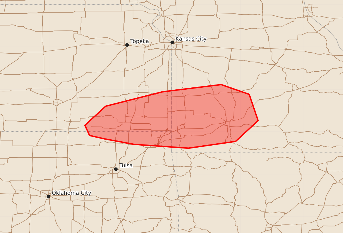
Summary
Severe thunderstorms capable of producing large hail and damaging wind gusts are expected across southeast Kansas, northeast Oklahoma, and southwest Missouri this afternoon. Potential hazards include hail up to 1.75 inches, wind gusts between 60 and 65 mph, and the possibility of brief tornadoes.
Product Text
000 ACUS11 KWNS 261838 SWOMCD SPC MCD 261838 MOZ000-OKZ000-KSZ000-262045- Mesoscale Discussion 1331 NWS Storm Prediction Center Norman OK 0138 PM CDT Fri Jun 26 2026 Areas affected...southeast Kansas...northeast Oklahoma...and southwest Missouri Concerning...Severe potential...Watch possible Valid 261838Z - 262045Z Probability of Watch Issuance...60 percent SUMMARY...Severe weather potential is expected to increase across the area this afternoon. Large hail up to 1.5-1.75" and severe wind gusts of 60-65 mph appear to be the primary hazards. Convective trends are being monitored for a Severe Thunderstorm Watch. DISCUSSION...Recent trends in visible satellite indicate deepening cumulus along an outflow boundary from near the Arkansas City to Independence, KS vicinities into southwest MO, north of Joplin. The air mass to the south of the boundary has warmed into the 80s, which, coupled with dewpoints in the low to mid 70s is resulting in MLCAPE of 1500-2500+ J/kg, per latest objective analysis. Large-scale forcing for ascent remains somewhat nebulous with the movement of several MCVs to the east of the region and no apparent upstream disturbances in water vapor imagery. Nonetheless, the presence of modest low-level warm advection observed by the KSGF VWP may be sufficient to support eventual storm development in the vicinity of the outflow boundary. Area VWPs and forecast soundings suggest deep-layer shear will be on the margins of that supportive of supercell storm modes. That, coupled with only modestly steep mid-level lapse rates, should limit hail size to 1.5-1.75". Damaging wind potential may ultimately be of greater concern owing to the very moist environment and potential for water-loaded downdrafts. A brief tornado is possible given sizable 0-3 km CAPE and ambient vorticity in the vicinity of the boundary. Otherwise, generally modest low-level shear should limit the overall tornado potential. Convective trends are being monitored for the potential issuance of a Severe Thunderstorm Watch. ..Mead/Guyer.. 06/26/2026 ...Please see www.spc.noaa.gov for graphic product... ATTN...WFO...SGF...EAX...TSA...ICT... LAT...LON 37609617 37949483 38119345 37889279 37269258 36779311 36619422 36709550 36839620 36919655 37159666 37609617 MOST PROBABLE PEAK TORNADO INTENSITY...UP TO 90 MPH MOST PROBABLE PEAK WIND GUST...55-70 MPH MOST PROBABLE PEAK HAIL SIZE...1.00-1.75 IN