Day 3 Convective Outlook
Issued: · Valid: –
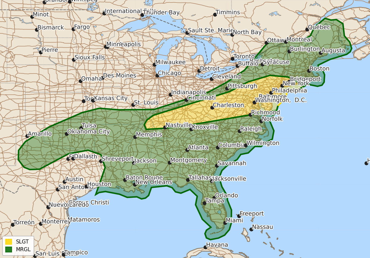
Summary
Isolated to scattered severe thunderstorms capable of producing damaging wind gusts are expected from Kentucky and northern Tennessee through the Mid-Atlantic on Thursday. Some areas in the Southeast may also experience isolated strong wind gusts and possible tornadoes due to a remnant tropical system.
Product Text
000 ACUS03 KWNS 161934 SWODY3 SPC AC 161932 Day 3 Convective Outlook NWS Storm Prediction Center Norman OK 0232 PM CDT Tue Jun 16 2026 Valid 181200Z - 191200Z ...THERE IS A SLIGHT RISK OF SEVERE THUNDERSTORMS FROM KENTUCKY AND NORTHERN TENNESSEE INTO THE MID-ATLANTIC... ...SUMMARY... Isolated to scattered severe thunderstorms will be possible from Kentucky to the Mid-Atlantic. Damaging wind gusts will be the main hazard with this activity. ...Synopsis... An upper trough will move across southern Quebec on Thursday. A trailing cold front from the Northeast into the southern Plains will serve as a focus for convection. A remnant tropical system will also promote scattered thunderstorms in the Southeast. ...Ohio Valley into the Northeast/Mid-Atlantic... As the upper trough slowly moves through southern Quebec, a belt of strong mid-level winds will be present across these regions. Mid-level flow will rapidly diminish from south of the mid/lower Ohio Valley latitude, however. Precipitation is expected to be ongoing along at least parts of the cold front early in the day. This will act to limit surface heating/destabilization into the afternoon. Even with that limitation, the very moist airmass ahead of the front will promote moderate (Mid-Atlantic/parts of Northeast) to strong (mid/lower Ohio Valley) buoyancy. Given the strong low/mid-level winds, potential exists for scattered damaging winds. ...Southern Plains into Mid-South... Strong instability is forecast south of a sagging cold front. Though these regions will be removed from the stronger mid-level winds, sufficient effective shear will be in place to promote potential for damaging downburst winds with the stronger storms/clusters that develop during the afternoon. ...Southeast... The remnants of Potential Tropical Cyclone 1 will continue to move through the northern Gulf into the Southeast on Thursday. With 70+ dewpoints likely to be ahead of this feature, even muted surface heating will promote moderate instability will develop. With locally enhanced shear near the remnant low, isolated strong wind gusts and perhaps a tornado or two will be possible. Should greater destabilization occur, higher probabilities could be warranted. ..Wendt.. 06/16/2026 $$