Day 3 Convective Outlook
This product has been superseded. View the updated product →
Issued: · Valid: –
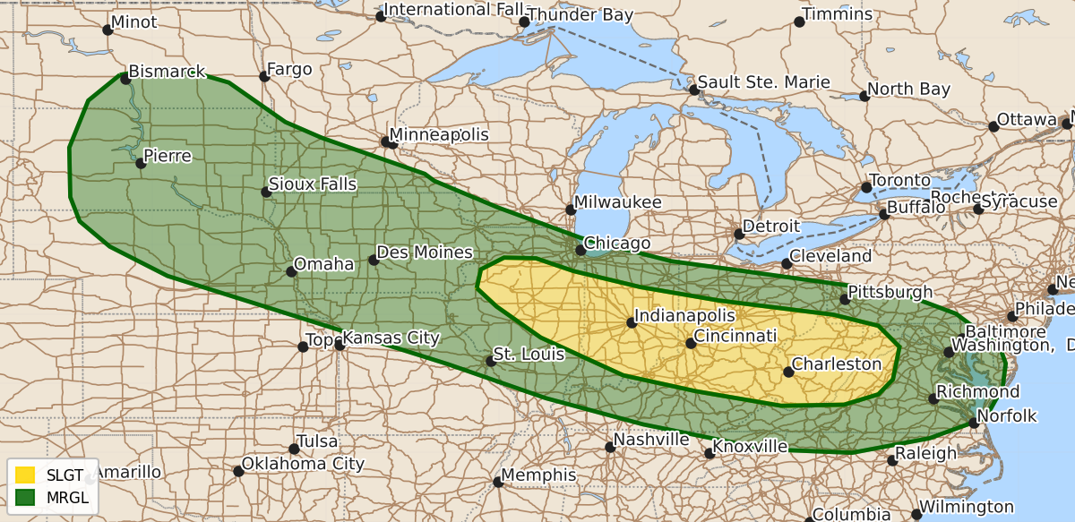
Summary
Severe thunderstorms capable of producing damaging wind gusts are expected across parts of the Ohio Valley and central Appalachians on Tuesday afternoon and evening. Isolated severe wind gusts and hail are also possible across parts of the central and northern Plains and the Midwest on Tuesday.
Product Text
000 ACUS03 KWNS 090725 SWODY3 SPC AC 090724 Day 3 Convective Outlook NWS Storm Prediction Center Norman OK 0224 AM CDT Sun Aug 09 2026 Valid 111200Z - 121200Z ...THERE IS A SLIGHT RISK OF SEVERE THUNDERSTORMS ACROSS PARTS OF THE OHIO VALLEY AND CENTRAL APPALACHIANS... ...SUMMARY... Thunderstorms with severe wind gusts will be possible on Tuesday over parts of the Ohio Valley and central Appalachians. Isolated severe gusts and hail will also be possible from parts of the central and northern Plains into the Midwest. ...Ohio Valley/Central Appalachians.... At mid-levels, west-northwesterly flow will be in place on Tuesday from the northern Plains to the central and northern Appalachians. Along the southern edge of the stronger mid-level flow, a west-northwest to east-southeast corridor of moderate to strong instability is forecast to develop by afternoon. It appears that an outflow boundary from the previous day's storms will be located from approximately north-central Illinois east-southeastward into southern Ohio. Low-level convergence along this boundary will be a focus for convective initiation. In the afternoon, thunderstorms are expected to develop near the boundary and move east-southeastward into the stronger instability over the Ohio Valley. A cluster of strong to severe storms is expected, and MCS development will be possible across the region. Instability is forecast to be similar to the previous day, with MLCAPE peaking in the 2000 to 3500 J/kg range. According to the ECMWF, deep-layer shear may be a bit stronger with 0-6 km shear in the 30 to 40 knot range. This would support supercells and short intense line segments capable of severe wind gusts. The wind-damage threat would become maximized if a cold pool can develop during the late afternoon and early evening. The current thinking is that the ECMWF has a better handle on where the outflow boundary will be than other solutions, and the Slight Risk area has been placed favoring the ECMWF scenario. ...Central and Northern Plains/Midwest... West-northwesterly mid-level flow will remain over the north-central U.S. on Tuesday. At the surface, dewpoints in the 60s and 70s F from South Dakota and Nebraska eastward into Iowa will contribute to strong destabilization by afternoon. MLCAPE is forecast to peak above 4000 J/kg along parts of the moist axis by late afternoon. In spite of the instability, large-scale ascent is forecast to remain relatively weak. Isolated to scattered storms could still develop along zones of low-level convergence. The strong instability along with moderate deep-layer shear should support an isolated severe threat from mid afternoon to mid evening. Severe wind gusts and hail will be the primary threats. Due to the weak forcing, there is some uncertainty as to where the greatest convective coverage will be. ..Broyles.. 08/09/2026 $$