Mesoscale Discussion 1173
Issued: · Valid: –
Summary
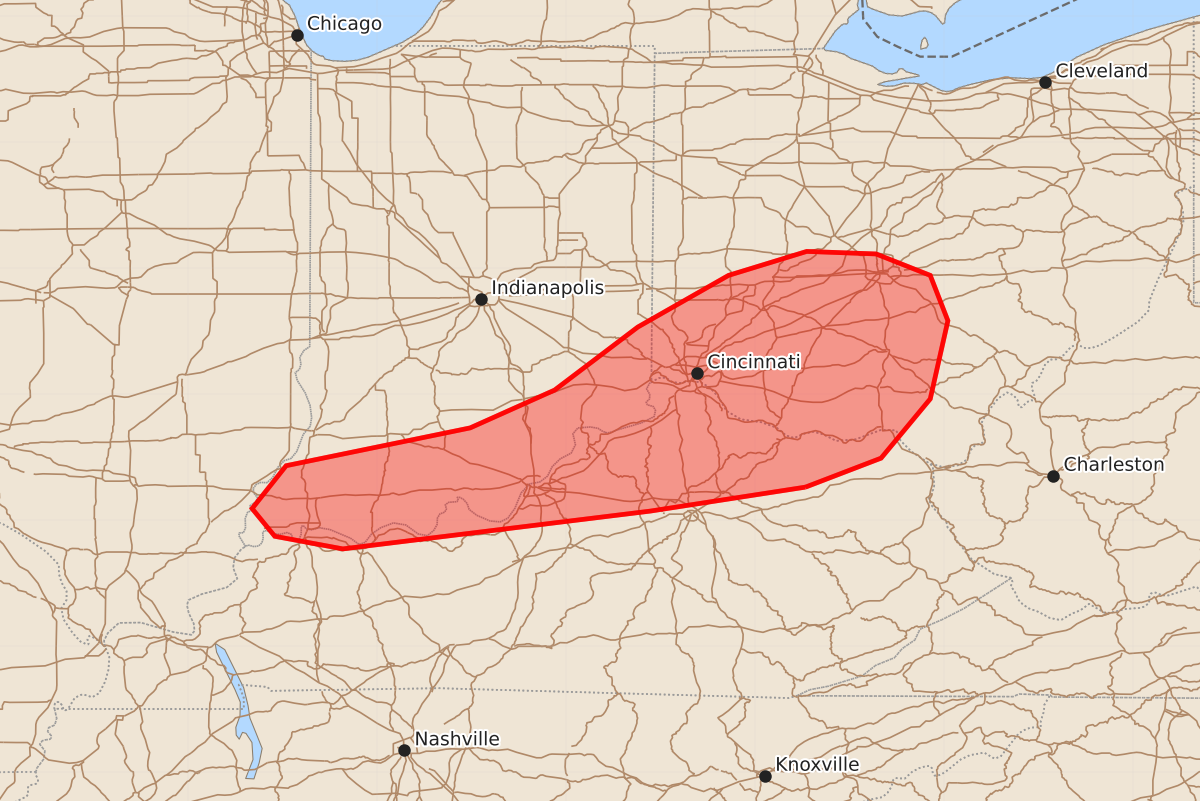
Severe thunderstorms capable of producing tornadoes, damaging winds, and large hail are expected to develop across southern Indiana, southwest/central Ohio, and northern Kentucky overnight. A tornado watch is likely for these areas during the late evening and early morning hours.
Product Text
000 ACUS11 KWNS 180128 SWOMCD SPC MCD 180127 OHZ000-KYZ000-INZ000-ILZ000-180400- Mesoscale Discussion 1173 NWS Storm Prediction Center Norman OK 0827 PM CDT Wed Jun 17 2026 Areas affected...Southern Indiana...southwest/central Ohio...and northern Kentucky Concerning...Severe potential...Tornado Watch likely Valid 180127Z - 180400Z Probability of Watch Issuance...80 percent SUMMARY...The severe risk will continue spreading/developing eastward tonight. A few tornadoes, damaging winds, and severe hail are all possible. DISCUSSION...As a midlevel wave and accompanying strong midlevel jet streak continue tracking eastward across the Midwest into the Great Lakes, an attendant surface low will track eastward from WI into Lower MI during the next several hours. In response, a 60-kt southerly LLJ (sampled by the IND VWP) will continue translating northeastward across eastern IN into central OH tonight. The wind profile across this region is already robust, with a large clockwise-curved hodograph sampled by the ILN 00Z sounding (300 m2/s2 effective SRH) -- and further increases in size/curvature can be expected with the strengthening LLJ. While buoyancy is marginal with eastward and northward extent, recovering PBL air should continue spreading east-northeastward tonight, supporting surface-based convection. As a result, the potential for severe storms (including supercells) capable of producing a few tornadoes, damaging winds, and severe hail will continue eastward into the overnight hours. A downstream tornado watch is likely. ..Weinman/Smith.. 06/18/2026 ...Please see www.spc.noaa.gov for graphic product... ATTN...WFO...RLX...JKL...ILN...LMK...IND...PAH... LAT...LON 38268360 38078483 37778727 37878781 38098799 38438772 38738626 39038559 39538493 39948421 40138359 40118304 39948261 39588247 38968261 38498300 38268360 MOST PROBABLE PEAK TORNADO INTENSITY...120-145 MPH MOST PROBABLE PEAK WIND GUST...65-80 MPH MOST PROBABLE PEAK HAIL SIZE...1.00-1.75 IN