Mesoscale Discussion 1312
Issued: · Valid: –
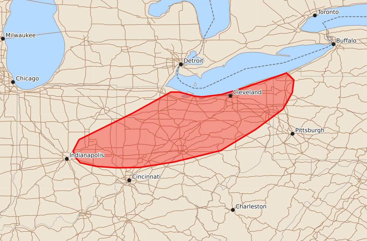
Summary
Thunderstorms moving through eastern Indiana, Ohio, and far western Pennsylvania this afternoon and early evening may produce damaging winds and large hail. The severe threat is expected to be sporadic with wind gusts up to 70 mph and hail up to 1.25 inches.
Product Text
000 ACUS11 KWNS 251911 SWOMCD SPC MCD 251910 PAZ000-OHZ000-INZ000-252115- Mesoscale Discussion 1312 NWS Storm Prediction Center Norman OK 0210 PM CDT Thu Jun 25 2026 Areas affected...Eastern Indiana into Ohio and far western Pennsylvania Concerning...Severe potential...Watch possible Valid 251910Z - 252115Z Probability of Watch Issuance...40 percent SUMMARY...Thunderstorms developing along and ahead of a diffuse cold front may pose a damaging wind and large hail threat through the afternoon and early evening hours. Watch issuance may be needed to address this concern. DISCUSSION...The early stages of convective development are well underway across eastern IN into northwest OH as destabilization continues along and ahead of a diffuse cold front. Additionally, growing cumulus is noted in GOES visible imagery across central OH where temperatures are warming into the low 80s. Continued thunderstorm development is expected through late afternoon as the front continues to migrate east/southeast and ascent ahead of an approaching upper wave/upper jet streak. Recent HRRR solutions appear to be capturing these trends well, and forecast sounding from recent runs depict fairly marginal mid-level lapse rates, but sufficient buoyancy profiles to utilize the strong deep-layer shear in place across the region. Consequently, a few supercells and/or organized convective bands appear possible through early evening as this activity spreads east across OH and eventually into far western PA. While the modest thermodynamic environment may modulate overall storm intensity, sporadic large hail and severe gusts up to 55-65 mph appear possible. Watch issuance may be needed if the severe threat becomes sufficiently widespread through the next few hours. ..Moore/Guyer.. 06/25/2026 ...Please see www.spc.noaa.gov for graphic product... ATTN...WFO...PBZ...RLX...CLE...ILN...IWX...IND... LAT...LON 40278583 40998437 41578332 41578309 41468267 41448247 41508195 41668141 42098016 41907996 41568000 41108026 40558100 39978196 39668323 39518417 39508480 39548536 39648580 39808594 39968599 40278583 MOST PROBABLE PEAK TORNADO INTENSITY...UP TO 90 MPH MOST PROBABLE PEAK WIND GUST...55-70 MPH MOST PROBABLE PEAK HAIL SIZE...UP TO 1.25 IN