Day 2 Convective Outlook
Issued: · Valid: –
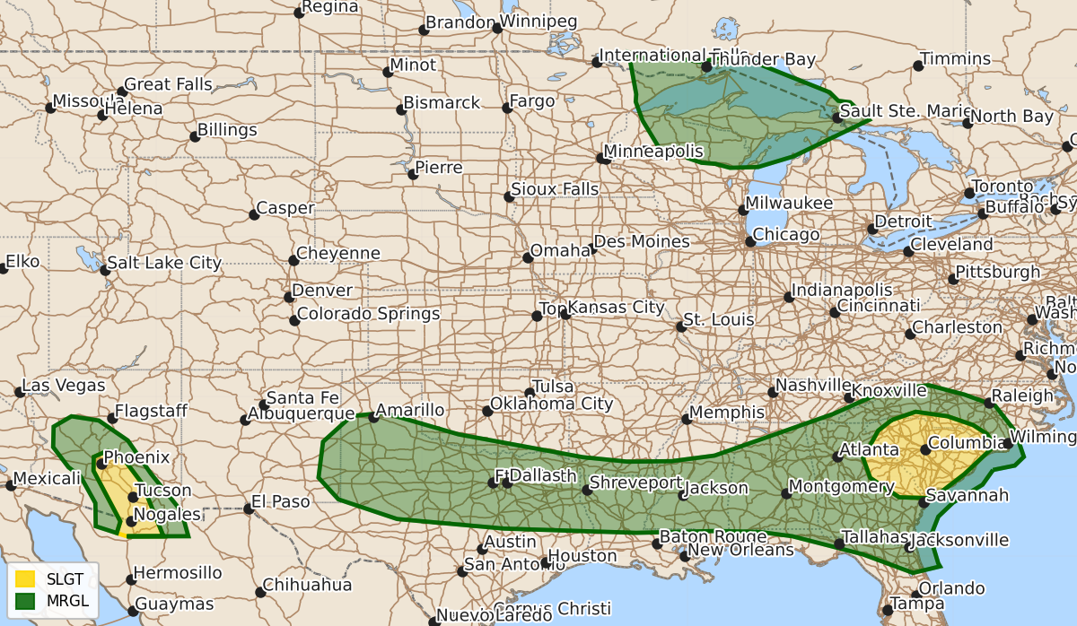
Summary
Scattered strong to severe thunderstorms capable of causing wind damage are expected across parts of the Carolinas and eastern Georgia on Sunday. Additionally, strong to severe thunderstorms with possible damaging wind gusts may occur across portions of central Arizona late Sunday afternoon into Sunday night.
Product Text
000 ACUS02 KWNS 111732 SWODY2 SPC AC 111730 Day 2 Convective Outlook NWS Storm Prediction Center Norman OK 1230 PM CDT Sat Jul 11 2026 Valid 121200Z - 131200Z ...THERE IS A SLIGHT RISK OF SEVERE THUNDERSTORMS PARTS OF EASTERN GEORGIA INTO THE CAROLINAS...PARTS OF CENTRAL ARIZONA... ...SUMMARY... Scattered strong-to-severe thunderstorms capable of producing wind damage will be possible across much of the Southeast on Sunday, with the greatest potential across South Carolina. Additional strong-to-severe thunderstorms will be possible across portions of Arizona late Sunday afternoon into Sunday night. ...Portions of Carolinas into eastern Georgia... An upper-level trough will continue to slide eastward north of these regions. A belt of stronger mid-level flow will be present across portions of the Carolinas, though winds will weaken with southwestward extent. A modest surface low is expected to develop along a stationary surface boundary. Scattered convection is possible during the afternoon within the very moist airmass south of the boundary. The most organized storms may exist along the boundary within North Carolina where shear will be stronger. However, surface heating may be more muted in this area. Stronger heating is more probable farther southwest, though shear will be weaker. Where the most favorable parameters overlap, scattered storms along with a few clusters will be capable of wind damage. ...Arizona... Model guidance continues to suggest that around 30 kt of mid-level easterly winds will persist into Sunday across the Mogollon Rim. Strong heating of the lower deserts along with greater moisture moving farther northwest will support widely scattered to scattered convection. Severe wind gusts will be possible with this activity during the late afternoon and early evening. ...Upper Great Lakes... Mid to upper 60s F dewpoints and steep mid-level lapse rates will support 2500-3000 J/kg MLCAPE by the afternoon. A passing shortwave trough to the northeast will promote moderate effective shear of 35-45 kt. With the upper ridge building in from the west, mid-level heights will be steadily rising through the period. This leads to uncertainty as to how many storms can form. The lake breeze boundaries present would likely be the focus for development. The environment would support large hail, damaging winds, and perhaps a tornado with a sustained supercell. Storm coverage precludes any upgrade in risk category, though storms could be intense if they form. ...Southern Plains into Southeast... Marginally severe storms are possible along and south of a stalled surface boundary. Afternoon buoyancy will be moderate to strong, but mid-level lapse rates and shear will generally be weak. Any greater threat for damaging winds will be tied to were organized clusters can form. ..Wendt.. 07/11/2026 $$