Day 1 Convective Outlook
Issued: · Valid: –
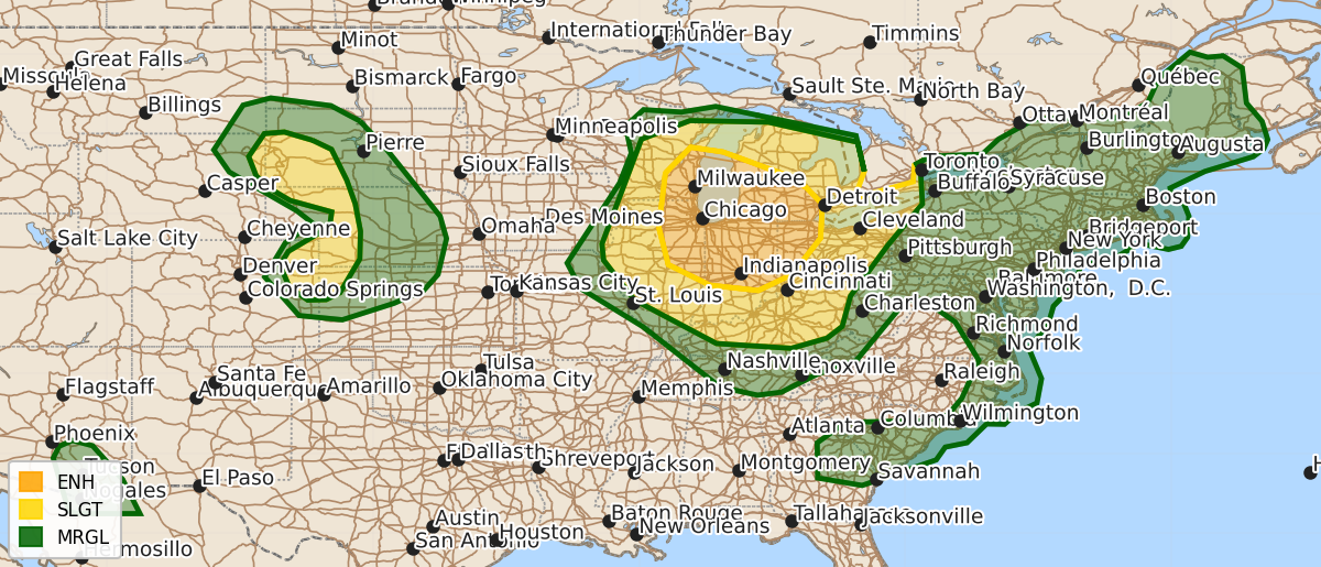
Summary
Severe thunderstorms capable of large hail and strong wind gusts are expected across the Great Lakes and Midwest through tonight, with an enhanced risk area. Damaging winds are also possible in the central High Plains, Mid-Atlantic, Tennessee Valley, and southeast Arizona throughout the day.
Product Text
000 ACUS01 KWNS 271651 SWODY1 SPC AC 271649 Day 1 Convective Outlook CORR 1 NWS Storm Prediction Center Norman OK 1149 AM CDT Mon Jul 27 2026 Valid 271630Z - 281200Z ...THERE IS AN ENHANCED RISK OF SEVERE THUNDERSTORMS ACROSS PARTS OF THE MIDWEST... ...THERE IS A SLIGHT RISK OF SEVERE THUNDERSTORMS OVER THE CENTRAL HIGH PLAINS... CORRECTED FOR THUNDERSTORM LINES ...SUMMARY... Severe storms capable of strong to severe wind gusts and large hail are expected across the Great Lakes and Midwest through tonight. More sporadic occurrences of damaging wind are possible in the Mid-Atlantic, Tennessee Valley, central High Plains, and southeast Arizona. ...Midwest/Ohio Valley... A large upper ridge remains present today over the central Plains/Rockies, with moderately strong northwest flow aloft from the Midwest into the OH Valley. A very moist and unstable low-level air mass resides from WI/IL into MI/IN/OH, where mostly clear skies will result in hot afternoon temperatures and MLCAPE values over 3000 J/kg. Multiple clusters of intense thunderstorms are ongoing over parts of WI tracking southeastward. These storms will move through this reservoir of high CAPE, leading to the potential for an active severe weather event today. However, details of how these clusters evolve are uncertain. Vertical shear across this region will support supercell structures, capable of damaging winds, hail, and isolated tornadoes this afternoon. However, the greater concern is if storms can congeal into a southeastward bowing system and that sweeps across Lower MI, eastern IL, IN, and western OH. Several morning CAM solutions indicate that risk, with storms spreading into KY overnight before weakening. Unfortunately, this synoptic pattern does not lend itself to a high-confidence convective forecast. ...High Plains... Widespread clouds are affecting parts of western NE this morning. However, strong heating will occur north and south of these clouds, leading to afternoon thunderstorms. The most active area will likely be over the Black Hills region where damaging winds and hail are possible. Farther south, widely scattered high-based thunderstorms will affect eastern CO/western KS with a risk of damaging wind gusts. ..Hart/Moore.. 07/27/2026 $$