Day 2 Convective Outlook
Issued: · Valid: –
Summary
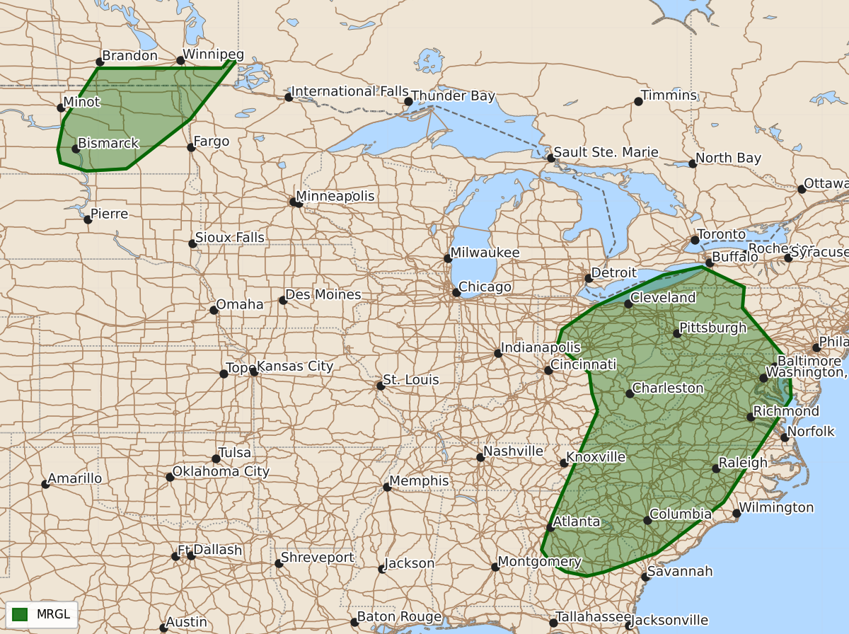
Isolated severe thunderstorms capable of producing damaging winds are possible across the upper Ohio Valley into the Carolinas and parts of Georgia on Sunday afternoon and evening. A conditional risk of severe storms with large hail and damaging winds exists for parts of North Dakota and northwest Minnesota late Sunday night.
Product Text
000 ACUS02 KWNS 011727 SWODY2 SPC AC 011725 Day 2 Convective Outlook NWS Storm Prediction Center Norman OK 1225 PM CDT Sat Aug 01 2026 Valid 021200Z - 031200Z ...THERE IS A MARGINAL RISK OF SEVERE THUNDERSTORMS FROM THE UPPER OHIO VALLEY INTO THE CAROLINAS AND PARTS OF GEORGIA...AND OVER A PART OF THE NORTHERN PLAINS... ...SUMMARY... Isolated occurrences of mainly damaging winds are possible from the upper Ohio Valley into the Carolinas and parts of Georgia Sunday afternoon and evening. A more conditional severe risk exists across parts of North Dakota into far northwest Minnesota late Sunday night. ...Synopsis... Weak troughing will bring modest flow and broad ascent across much of the eastern US. Enhanced westerly flow will overspread the northern periphery of the western ridge across the Northern Rockies as a more progressive mid-level low moves across the Canadian Prairies. At the surface, an occluding surface low will shift northeast across the Ohio Valley into the Northeast, with a trailing cold front slowly shifting east across the Ohio Valley into the Gulf States. A cold front will shift across portions of the Northern Rockies into the northern Plains. ...Upper Ohio Valley into the Southeast... Broad forcing for ascent within the region of the eastward sagging cold front will produce widely scattered thunderstorm activity across much of the region from the Ohio Valley to the Southeast. Activity will likely be ongoing at the start of the period from the northern Ohio Valley into the Appalachians. Broken mid-level cloud cover behind the morning convection should allow for sufficient heating/destabilization and moderate instability ahead of the cold front by the afternoon. This in combination with deep layer shear around 25-35 kts will support isolated strong storms capable of damaging wind where better heating can occur. ...Northern Plains... A conditional severe threat will extend across potions of North Dakota into northern Minnesota. Within this region, the environment will be favorable for severe storms, with moderate to strong instability and strong deep layer shear. However, weak forcing for ascent and strong capping at the base of the EML during the daytime heating period may limit development until mid-level cooling and ascent from the upper wave moves in late. Nonetheless, should a cell or two develop the environment would support potential for large hail and damaging wind. It appears most likely that convection develops along the cold front toward the end of the D2 period, with potential for large hail and damaging wind. ..Thornton.. 08/01/2026 $$