Day 3 Convective Outlook
Issued: · Valid: –
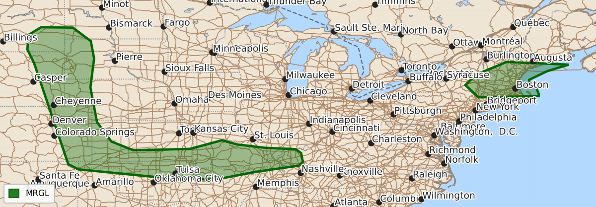
Summary
Isolated severe thunderstorms capable of large hail, damaging winds, and possibly tornadoes are expected on Friday across the High Plains, southern Kansas, northern Oklahoma, the Ozarks, and the Ohio Valley. Additional severe storms capable of damaging wind are also possible across portions of the Northeast on Friday.
Product Text
000 ACUS03 KWNS 241930 SWODY3 SPC AC 241929 Day 3 Convective Outlook NWS Storm Prediction Center Norman OK 0229 PM CDT Wed Jun 24 2026 Valid 261200Z - 271200Z ...THERE IS A MARGINAL RISK OF SEVERE THUNDERSTORMS ACROSS PORTIONS OF THE HIGH PLAINS...SOUTHERN KANSAS AND NORTHERN OKLAHOMA...THE OZARKS INTO THE OHIO VALLEY...AND PORTIONS OF THE NORTHEAST... ...SUMMARY... Isolated severe storms capable of large hail and severe wind gusts will be possible across the High Plains, southern Kansas and northern Oklahoma, and southern Missouri into northern Arkansas/western Kentucky on Friday. Additional severe storms capable of damaging wind will also be possible across portions of the Northeastern US. ...Synopsis... A strengthening mid-level trough will move inland across portions of the Pacific Northwest on D3/Friday, with enhanced mid-level flow spreading into the northern Rockies and northern Plains. Height rises will occur across the High/central High Plains. A shortwave trough will move across portions of the Northeast. A surface low will move northward into Quebec with a trailing cold front extending from the Northeastern US into the Ohio Valley and south and west into the Southern Plains to a surface low across the Oklahoma/Texas Panhandles. Lee cyclogenesis is expected across the northern Plains late in the period. ...High Plains... Height rises are expecting amid building mid-level ridging across the High Plains. As the trough deepens to the west across the Pacific Northwest, strong southwesterly mid-level flow will overspread the western portion of the ridge. Despite height rises, a few isolated supercells may develop across portions of eastern Montana into eastern Wyoming/Colorado, given moderate instability and deep layer shear around 30-40 kts progged by late afternoon. ...Southern Kansas and northern Oklahoma into the Ozarks and western Ohio Valley... Strong instability is forecast near the frontal boundary across northern Oklahoma into southern Kansas Friday afternoon. Forcing for ascent will remain somewhat weak, with some mid-level height rises expected. However, it appears that thunderstorm activity will develop along the front from southern Kansas into northern Oklahoma spreading eastward into the Ozarks and perhaps the Ohio Valley by late afternoon/evening. Guidance suggests that MLCIN will strengthen south of the front across central Oklahoma into Arkansas, which will likely limit convection to near and just south of the boundary. Along the front, deep layer shear around 30-40 kts will support organized storms and perhaps a few supercells capable of large hail and damaging wind. As the low-level jet increases through the afternoon/evening, thunderstorm coverage will likely increase with some increase in potential for a tornado. ...Northeast... As a surface low moves northward into Quebec Friday, a cold front will shift south and eastward across the Northeastern US. Strong upper-level westerly flow with thunderstorms developing along and ahead of the cold front by the afternoon. A pocket of moderate instability overlapping strong deep layer shear around 50 kts will support a few organized severe storms capable of damaging wind. ..Thornton.. 06/24/2026 $$