Day 1 Convective Outlook
This product has been superseded. View the updated product →
Issued: · Valid: –
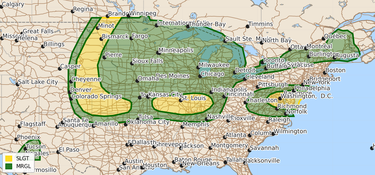
Summary
Severe thunderstorms capable of producing damaging wind gusts and hail are expected this afternoon and evening across portions of the Central and Northern Plains, the Lower Missouri and Ohio Valleys, the Mid-Atlantic, and parts of Arizona. These storms vary in intensity, with some areas in the Northern Plains potentially seeing large hail and strong downdrafts.
Product Text
000 ACUS01 KWNS 091249 SWODY1 SPC AC 091248 Day 1 Convective Outlook NWS Storm Prediction Center Norman OK 0748 AM CDT Thu Jul 09 2026 Valid 091300Z - 101200Z ...THERE IS A SLIGHT RISK OF SEVERE THUNDERSTORMS ACROSS PORTIONS OF THE NORTHERN AND CENTRAL PLAINS...FROM THE LOWER MISSOURI VALLEY INTO THE LOWER OHIO VALLEY...AND PORTIONS OF THE MID-ATLANTIC... ...SUMMARY... Thunderstorms with severe wind gusts and hail will be possible this afternoon and evening across parts of the central and northern Plains. Severe wind gusts may also occur in parts of the Ozarks, mid Mississippi Valley, lower Ohio Valley, Mid-Atlantic and Arizona. ...Central High Plains into the Central Plains... A similar thermodynamic environment to yesterday is expected across the central Rockies today, with scattered afternoon thunderstorm development anticipated. The presence of a low-amplitude shortwave trough could lead to greater storm coverage today versus yesterday. Moist post-frontal easterlies will help offset mixing across much of the region, keeping dewpoints in the upper 50s/low 60s across east-central/northeast CO, with higher dewpoints farther east into southern NE and western/central KS. Moderate westerly flow aloft will support organized storm structures into this more buoyant environment, with an attendant threat for strong to severe gusts with the stronger bowing segments. There is some potential for a contiguous line of storms from the NE Panhandle across eastern CO if widespread cold pool amalgamation is realized. Uncertainty regarding convective evolution precludes higher probabilities with this outlook, but increased probabilities may be needed later if forecast confidence increases. ...Northern Plains... A somewhat separate convective regime is expected across the northern Plains versus farther south. Here, strong heating of a moist airmass beneath steep mid-level lapse rates will support robust buoyancy this afternoon, with MLCAPE over 2000 J/kg anticipated. The better forcing for ascent will remain north of the region and some convective inhibition may linger, but convergence along a modest cold front and/or pre-frontal trough/low will likely result in at least isolated thunderstorms. Strong buoyancy combined with effective bulk shear around 30-35 kt should support a few supercells. Large to isolated very large hail and strong downdrafts are possible within the more organized storms. ...Lower MO Valley into the Lower OH Valley... An MCS is currently tracking southeastward through central MO, with occasionally strong gusts noted on its leading edge. Continued eastward progression away from the low-level jet, coupled with the decreasing strength of the jet, will likely lead to a weakening of this MCS this morning. However, the moist airmass downstream will diurnally destabilize, likely resulting in a reintensification of the MCS and/or development of new storms along its leading edge. Additional development is possible in the wake of this MCS, amid low-level moisture convergence along a potential differential heating boundary. Vertical shear will be weak, but moderate/strong buoyancy and steep low-level lapse rates will support strong cold pools and the potential for damaging gusts. ...Mid-Atlantic... A moist airmass will remain in place across the Mid-Atlantic today, characterized by afternoon dewpoints in the upper 60s to mid 70s. Airmass destabilization is expected by the early afternoon, with moderate to strong buoyancy (i.e. MLCAPE from 1500 to 2000 J/kg) likely. A low-amplitude shortwave trough currently over TN/KY is forecast to progress northeastward, interacting with the moist and unstable airmass to support thunderstorms. While the thermodynamic characteristics of the airmass remain similar to the last few days, increased large-scale ascent and slightly stronger mid-level flow attendant to the shortwave will likely support greater storm coverage and intensity. Moderate vertical shear will support a predominantly outflow-dominant multicellular mode, with damaging wind gusts as the primary risk, particularly in areas where few clouds allow for more heating and steeper low-level lapse rates. ...Upper Great Lakes into northern New England... Moderate westerly/southwesterly flow aloft at the base of a shortwave trough moving across Ontario and Quebec will extend from the Upper Great Lakes region through New England this afternoon. A modest cold front associated with the shortwave will shift eastward/southeastward into the region as well, interacting with the warm, moist and unstable airmass in place to support scattered thunderstorms this afternoon. Poor mid-level lapse rates will keep buoyancy modest, but the moderate westerly/southwesterly flow aloft could still support some stronger bowing segments capable of damaging gusts. ...Southeast Arizona... Mid-level moisture will support afternoon thunderstorm development across the higher terrain of southeast AZ/southwest NM. Southwestward storm motion associated with modest mid-level easterly/northeasterly flow could take a few of these storms into the hot and deeply mixed airmass across southeast AZ. Strong downdrafts are possible with any stronger storms. ..Mosier/Thornton.. 07/09/2026 $$