Day 1 Convective Outlook
Issued: · Valid: –
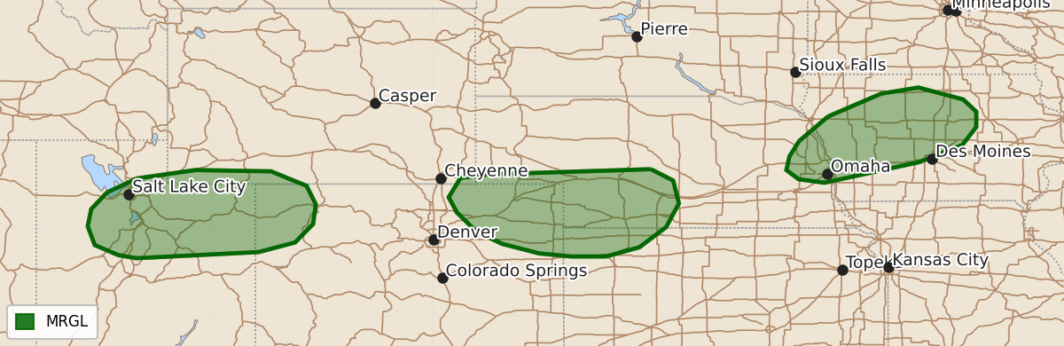
Summary
Isolated severe thunderstorms capable of producing wind gusts or hail may occur this evening across parts of the mid Missouri Valley, the Central High Plains, and the Intermountain West.
Product Text
000 ACUS01 KWNS 190047 SWODY1 SPC AC 190045 Day 1 Convective Outlook NWS Storm Prediction Center Norman OK 0745 PM CDT Fri Sep 18 2026 Valid 190100Z - 191200Z ...THERE IS A MARGINAL RISK OF SEVERE THUNDERSTORMS ACROSS PARTS OF THE MID MISSOURI VALLEY...CENTRAL HIGH PLAINS AND INTERMOUNTAIN WEST... ...SUMMARY... Thunderstorms with isolated severe wind gusts will be possible this evening across parts of the mid Missouri Valley and Central High Plains. A few severe wind gusts and hail may occur in parts of the Intermountain West. ...Mid Missouri Valley... An upper-level ridge is currently present in the central U.S, with a 30 to 40 knot low-level jet located near the ridge in the mid Missouri Valley. Isolated thunderstorms have developed early this evening in eastern Nebraska, near the axis of the low-level jet. Surface dewpoints in eastern Nebraska are in the lower to mid 70s F, with the RAP showing MLCAPE in the 1000 to 2000 J/kg range. While the 00Z Omaha sounding has 0-6 km shear of 20 to 25 knots, deep-layer shear is likely a bit stronger southward in the vicinity of the low-level jet. This could be enough for an isolated wind-damage threat. The threat may develop northeastward into western and central Iowa this evening as low-level flow and convective coverage both increase. ...Central Plains... An anti-cyclonic flow pattern is present over much of the north-central U.S. The eastern extension of a mid-level shortwave trough, evident on water vapor imagery, is located over east-central Colorado. Scattered thunderstorms are ongoing just ahead of the trough from northeast Colorado into southwest Nebraska, where the RAP has MLCAPE in the 1000 to 2000 J/kg range. The WSR-88D VWPs at Goodland and Cheyenne have 0-6 km shear in the 30 to 40 knot range, suggesting that an isolated severe threat will be possible early this evening. Severe wind gusts will be the primary threat. ...Intermountain West... On water vapor imagery, southwesterly mid-level flow is present from the central Rockies into the central High Plains. A mid-level shortwave trough appears to be located from near the Unita Mountains in northeast Utah eastward into the central Rockies of Colorado. Large-scale ascent associated with the trough is supporting scattered thunderstorm development. The RAP shows the strongest instability across northeast Utah and northwest Colorado, where moderate deep-layer shear and modestly steep lapse rates are evident on RAP analysis. This could be enough for an isolated potential for severe wind gusts and hail over the next few hours. ..Broyles.. 09/19/2026 $$