Day 1 Convective Outlook
This product has been superseded. View the updated product →
Issued: · Valid: –
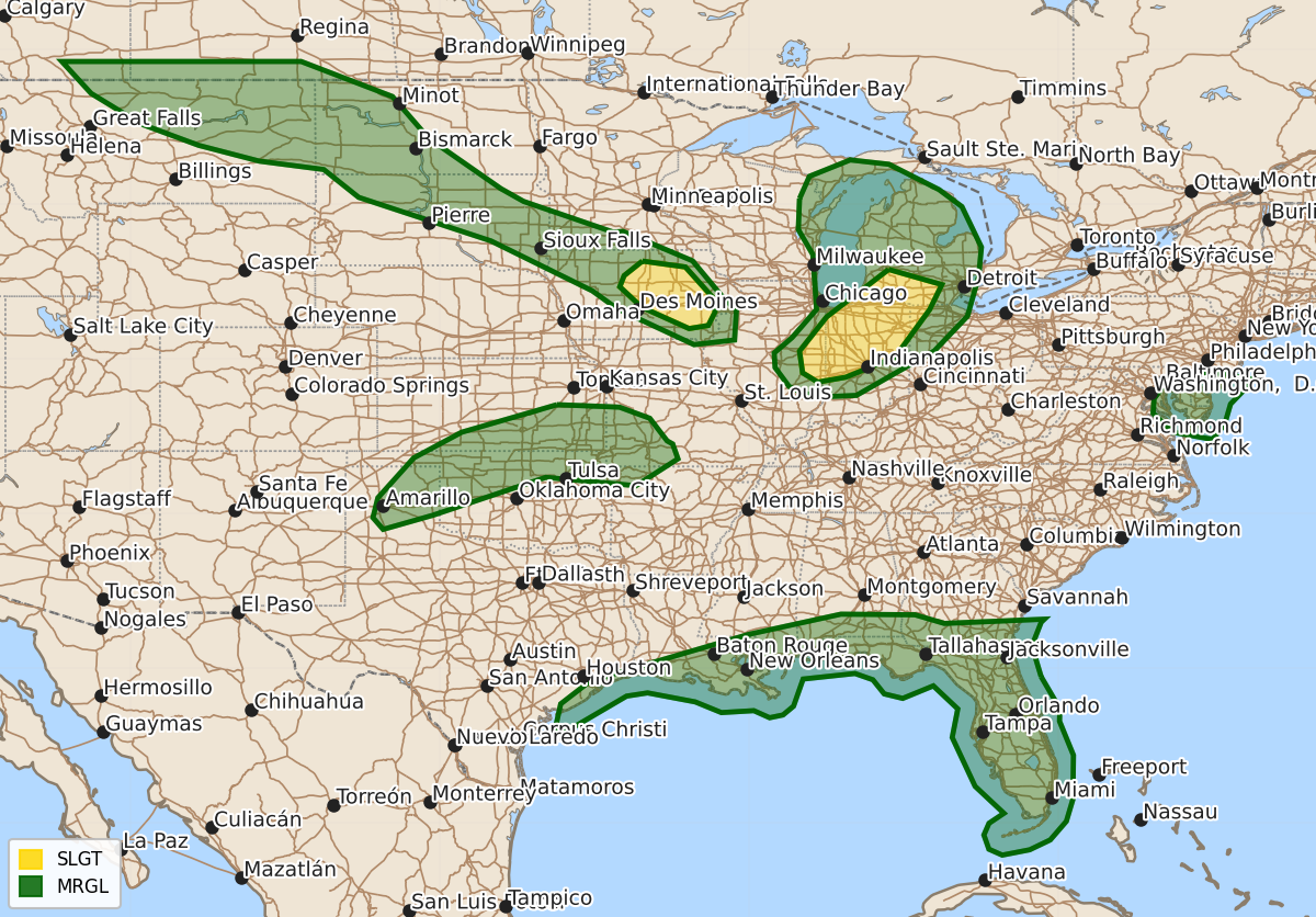
Summary
Severe thunderstorms capable of producing large hail, damaging winds, and tornadoes are expected across parts of eastern Illinois, Indiana, and lower Michigan this afternoon and evening, as well as across Iowa tonight. Additional isolated severe storms may occur late this afternoon and tonight across the southern and central Plains, the northern Plains, and the Gulf Coast.
Product Text
000 ACUS01 KWNS 161957 SWODY1 SPC AC 161955 Day 1 Convective Outlook NWS Storm Prediction Center Norman OK 0255 PM CDT Tue Jun 16 2026 Valid 162000Z - 171200Z ...THERE IS A SLIGHT RISK OF SEVERE THUNDERSTORMS OVER PARTS OF EASTERN ILLINOIS...INDIANA AND LOWER MICHIGAN THROUGH THIS EVENING AND IOWA TONIGHT... ...SUMMARY... Severe thunderstorms remain possible this afternoon and tonight across multiple parts of the Midwest, as well as on a more isolated basis across the Gulf Coast, south-central Plains and northern Plains. ...20z Update Wisconsin and Michigan to Illinois and Indiana... Beneath the cold core of the clipper, steep mid-level lapse rates and weak buoyancy are supporting scattered thunderstorms. While available MUCAPE is somewhat limited (500-750 J/kg) 500 mb temps near -20C are supportive of marginally severe hail with the stronger cores. This threat should end by evening as buoyancy declines with the loss of diurnal heating. Have expanded the 5% hail across Lake Michigan into the UP and eastern WI shores. Southern portions of the Level 2 Slight risk were also expanded into eastern IL where robust convection is expected along the cold front this afternoon and evening. Hail, damaging gusts and a couple of tornadoes remain possible. ...MT and northern Plains into the Midwest tonight... Ahead of the strong belt of mid-level flow ahead of the upper trough moving out of Canada, afternoon model guidance remains bullish on several rounds of strong and occasionally severe storms late tonight into early Wed. However, CAPE will be rather weak, which should limit overall convective organization. Isolated severe gusts remain possible. The upstream convection will eventually intersect with a rapidly moistening air mass across parts of IA and the Midwest. This will likely result in a cluster of more robust severe storms near daybreak across SD, IA and MN at the nose of a 50+ kt 850 mb jet. Increasingly strong vertical shear from the upstream trough/jet will support supercells or elevated bowing segments capable of hail and severe wind gusts by 12z Wed. Have connected the MRGL areas over the northern Plains into the Midwest. ...Southern and central Plains... Strong heating along the stalled front initially over the southern and central Plains could result in isolated to widely scattered thunderstorms late this afternoon and early evening. Increasing vertical shear and low-level moisture advection could favor some risk for hail with supercells. However, warm temperatures aloft and only modest large-scale forcing for ascent casts considerable uncertainty on storm development/maintenance this evening. Should a supercell or two become established, large hail and damaging gusts would be possible before ending overnight. ..Lyons.. 06/16/2026 .PREV DISCUSSION... /ISSUED 1113 AM CDT Tue Jun 16 2026/ ...IN/Lower MI... Morning water vapor loop shows a strong and progressive Clipper system tracking southeastward across MN/WI. A band of clouds and isolated thunderstorms precedes this system, extending from southern Lower MI into central IL. While a few strong storms are possible to develop in this band, the greater risk for severe storms appears to be associated with a period of heating in the wake of these clouds. Steep lapse rates and cold temperatures aloft will combine with dewpoints around 60F to result in sufficient afternoon/evening CAPE for widely scattered strong/severe storm development. Large hail will be the initial main concern, along with some risk of a tornado or two. By early evening, damaging winds will be the main concern. ...IA Overnight... The next in a series of fast-moving upper-level features will move across the Dakotas tonight, with large-scale forcing for ascent spreading into parts of MN/IA before 12z. This ascent will begin interacting with a plume of returning moisture, leading to scattered thunderstorm development in the pre-dawn hours. Elevated supercells capable of large hail will be the main risk through 12z. ...MT/ND... The aforementioned upper feature will affect northeast MT and the Dakotas this afternoon and evening. A deeply-mixed boundary layer will develop over this area with temperatures in the 80s and 35-45F t-td spreads. CAPE will be rather weak, which should limit overall convective organization. Nevertheless, fast-moving high-based showers and thunderstorms capable of gusty and occasionally severe wind gusts are expected. ...Gulf Coast... The tropical system (PTC 1) along the south TX coast is expected to slowly organize today, with widespread showers and thunderstorms from east TX into the central Gulf coast. Low-level winds are not particularly strong and forecast hodographs are only marginally favorable for updraft rotation. Nevertheless with such a broad area of risk, a tornado or two is certainly possible this afternoon through tonight. $$