Day 1 Convective Outlook
Issued: · Valid: –
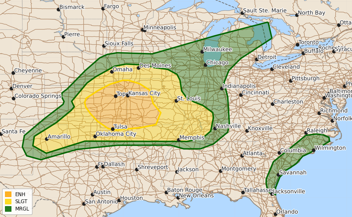
Summary
Scattered severe thunderstorms are expected today and tonight across central and eastern Kansas, western Missouri, northeast Oklahoma, and northwest Arkansas. These storms may bring damaging wind gusts, large hail, and a few tornadoes.
Product Text
000 ACUS01 KWNS 132003 SWODY1 SPC AC 132002 Day 1 Convective Outlook NWS Storm Prediction Center Norman OK 0302 PM CDT Sat Jun 13 2026 Valid 132000Z - 141200Z ...THERE IS AN ENHANCED RISK OF SEVERE THUNDERSTORMS ACROSS CENTRAL TO EASTERN KANSAS AND WESTERN MISSOURI AND ADJACENT PORTIONS OF NORTHEAST OKLAHOMA AND FAR NORTHWEST ARKANSAS... ...SUMMARY... Scattered severe thunderstorms are likely today and tonight from parts of the central and southern Plains to the Lower Missouri and Middle Mississippi Valleys. Swaths of damaging wind gusts, large hail, and a few tornadoes are all possible. ...20z Update... Only minor modifications were needed to the ongoing forecast based on recent convective trends. The primary hazard continues to be initially hail along the front with the onset of convection followed by rapid upscale growth with an attendant severe wind threat across eastern KS into adjacent portions of AR, MO, and OK. Given the prevalence of outflow boundaries intersecting the front per recent surface observations, there will likely be one or more mesoscale corridors of higher tornado potential as one or more MCSs develop, however, confidence is limited in how productive these corridors will be give the expectation of upscale growth. For additional short-term details see MCDs #1122, #1123, and #1124. ..Moore.. 06/13/2026 .PREV DISCUSSION... /ISSUED 1130 AM CDT Sat Jun 13 2026/ ...Central/Southern Plains to Middle Mississippi Valley... Several different areas are already convectively active this morning, including south-central IA/north-central MO where a bowing segment is moving southeastward through the region, and farther south from central/southern MO into far west-central IL, where elevated thunderstorm are being maintained by modest warm-air advection. Most immediate severe potential is downstream of the bowing segment in south-central IA/north-central MO where damaging wind gusts and isolated hail are possible over the next few hours. Thereafter, expansive coverage of the ongoing storms in central/southern MO introduces notable uncertainty regarding the extent and strength of afternoon destabilization. General expectation is for the ongoing showers and thunderstorms to persist, aided by mesoscale ascent attendant to an MCV traversing the region. Cloud cover will limit heating, but ample low-level moisture will still support moderate buoyancy. Moderate deep-layer shear is anticipated over this area as well, with perhaps some more mesoscale enhancement attendant to the MCV. As a result, a few stronger embedded multicells and isolated supercells are possible. Isolated large hail and damaging gusts could occur with the strongest storms embedded within this likely broad area of showers and thunderstorms. A more complex scenario is anticipated along the western edge of the MO cluster, extending back further westward into north-central KS. Current surface analysis shows an outflow boundary over extreme southeast NE arcing back through north-central KS to a low over far northwest KS. A more substantial surface low exists over southwest KS. Surface analysis also places a cold front from northwest IA southwestward to just north of the northwest KS low in far southwest NE. These boundaries should all influence convective evolution today, with the outflow/differential heating boundary along the western edge of the MO cluster likely playing a part as well. Strong diurnal heating/steepening low-level lapse rates preceding the surface lows will result in scattered thunderstorm development near/ahead of the southeast-moving cold front, with the most intense development likely favoring where the front intercepts the western periphery of the outflow boundary. This intersection will most likely be over central into northeast KS. Strong buoyancy and moderate deep-layer shear will support robust updrafts capable of large to very large hail early in the convective cycle, before transitioning to a more linear mode as the front continues southeastward. Another area of afternoon thunderstorm development is anticipated from southern MO into west-central MO and far southeast KS, along the western edge of the outflow/differential heating associated with the ongoing MO cluster. Like the area farther northwest, large to isolated very large hail is anticipated initially. Additionally, this region could act as a corridor for upscale growth as the development along the cold front begins to interact with the more in-situ development along this boundary. Damaging winds will be the most prominent risk within this corridor this evening, potentially including some significant (75+ mph) wind gusts. Despite numerous boundaries, the environmental conditions (i.e. high LCLs and modest surface wind) and anticipated convective evolution (i.e. outflow-dominant storms with quick evolution towards a linear mode) only suggest a low-probability tornado threat from discrete storms. A somewhat higher tornado risk could materialize within any more robust convective line that develops, particularly during evening as the low-level jet increases. ...Lower MI... Scattered thunderstorms are expected along and ahead of a cold front moving through the region today. Strong low to mid-level flow could support a few more organized storms, beginning across northern Lower MI now and then extending back southwestward with time this afternoon/evening. Primary risks are isolated large hail and damaging gusts, but a brief tornado is possible as well. ...Carolinas/Coastal Southeast... Ample heating within a moist environment south of a weak front will result in moderately strong diurnal destabilization, with convective development aided by the front and coastal sea breeze. Some pulse-type locally severe storms capable of downbursts/wind damage may occur this afternoon through around sunset. $$