Day 2 Convective Outlook
Issued: · Valid: –
Summary
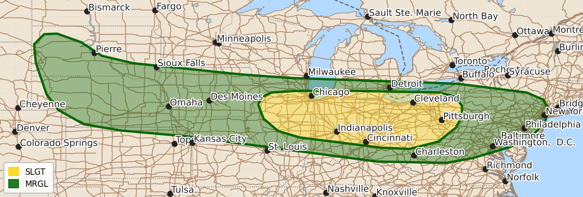
Severe thunderstorms with damaging wind gusts are possible Monday afternoon and evening from northern Illinois through western Pennsylvania. Isolated severe wind gusts and hail are also expected Monday afternoon across parts of the central and northern Plains and the Midwest.
Product Text
000 ACUS02 KWNS 090544 SWODY2 SPC AC 090542 Day 2 Convective Outlook NWS Storm Prediction Center Norman OK 1242 AM CDT Sun Aug 09 2026 Valid 101200Z - 111200Z ...THERE IS A SLIGHT RISK OF SEVERE THUNDERSTORMS ACROSS PARTS OF THE SOUTHERN GREAT LAKES... ...SUMMARY... Thunderstorms with severe wind gusts will be possible Monday afternoon and evening from northern Illinois eastward into western Pennsylvania. Isolated severe gusts and hail will also be possible from parts of the central and northern Plains into the Midwest. ...Southern Great Lakes... At mid-levels, west-northwesterly flow will be in place on Monday from the northern Plains into the Great Lakes. A subtle mid-level shortwave trough and an associated jet streak will move through the Great Lakes. To the south of the jet streak, a cold front is forecast to advance southward into northern Illinois, northern Indiana and northern Ohio by mid afternoon. Low-level convergence along the front will be a focus for convective development. To the south of the front, surface dewpoints in the 70s F will contribute to moderate to strong destabilization by afternoon, with MLCAPE likely peaking in the 2000 to 3500 J/kg range. Thunderstorms are expected to develop near the front and move east-southeastward into the stronger instability during the afternoon and evening. Along the instability axis in the late afternoon from Lincoln, Illinois to Pittsburgh, Pennsylvania, the ECMWF has 0-6 km shear around 30 knots. This should support a mixed mode, with short intense line segments and embedded rotating storms possible. The primary threat will damaging wind gusts, with the maximum threat located ahead of any cold pool that can organize. The severe threat could persist into the early to mid evening, especially if MCS development takes place, maintained by increasing low-level flow. ...Central and Northern Plains/Midwest... West-northwesterly mid-level flow will be in place over the north-central U.S. on Monday. A subtle shortwave trough is forecast to move east-southeastward across the northern Plains. At the surface, a cold front is forecast to advance southward across western South Dakota during the day, with a dryline extending southward into western Nebraska. To the east of the dryline, surface dewpoints in the 60s and 70s F will contribute to moderate to strong instability by afternoon. Isolated thunderstorms appear likely to develop near the dryline during the mid to late afternoon. Additional isolated storms are expected to develop further east along the moist axis from eastern Nebraska into Iowa. Forecast sounding along the moist axis in the late afternoon have MLCAPE peaking in the 3000 to 4000 J/kg range with 0-6 km shear around 30 knots. This environment, combined with steep low to mid-level lapse rates, will support isolated potential for severe wind gusts and hail. ..Broyles.. 08/09/2026 $$