Day 1 Convective Outlook
This product has been superseded. View the updated product →
Issued: · Valid: –
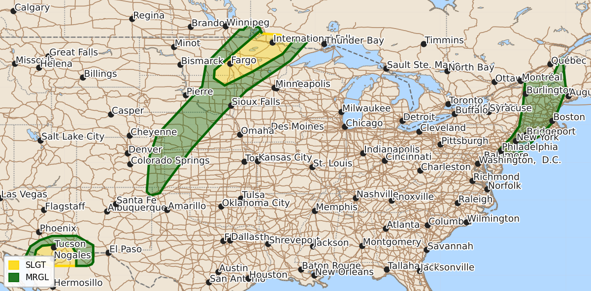
Summary
Scattered severe thunderstorms are possible today into tonight across parts of the eastern Dakotas into northern Minnesota and across portions of southern Arizona. These storms may produce large hail, damaging wind gusts, and an isolated tornado.
Product Text
000 ACUS01 KWNS 031632 SWODY1 SPC AC 031630 Day 1 Convective Outlook NWS Storm Prediction Center Norman OK 1130 AM CDT Mon Aug 03 2026 Valid 031630Z - 041200Z ...THERE IS A SLIGHT RISK OF SEVERE THUNDERSTORMS ACROSS PARTS OF THE NORTHERN PLAINS INTO THE UPPER MIDWEST...AND SOUTHERN ARIZONA... ...SUMMARY... Scattered severe thunderstorms are possible today into tonight across parts of the eastern Dakotas into northern Minnesota, as well as across portions of southern Arizona. ...Northern/Central Plains into the Upper Midwest... Post-frontal thunderstorms occurring this morning across ND have remained mostly sub-severe over the past couple of hours. A stout low-level inversion noted on the observed 12Z INL sounding will likely inhibit surface-based thunderstorms from developing until late this afternoon or early evening across the eastern Dakotas into northern MN. Still, gradual airmass destabilization is anticipated across this region along/ahead of a cold front through the afternoon. Large-scale ascent attendant to an ejecting mid-level shortwave trough from MT into ND will eventually aid scattered convective development along/near the front, most likely by 22-01Z. Moderate instability coupled with strong deep-layer shear will support some threat for supercells and large hail initially, before upscale growth into clusters supports an increasing severe/damaging wind threat with eastward extent into northern MN this evening. A tornado or two may also occur as low-level shear gradually increases in a narrow corridor ahead of the front this evening. Isolated to widely scattered thunderstorm development is forecast with southward extent into the central High Plains. A hot and very well-mixed low-level airmass ahead of the front/surface trough across this area may support occasional severe gusts with convective outflow. But, weaker mid-level winds and related modest deep-layer shear should result in only loosely organized clusters/cells. This activity should weaken with the loss of daytime heating. ...Southwest... Around 15-25 kt of east-northeasterly mid-level winds will persist today across far southern AZ/NM, to the south of prominent upper ridging that will remain anchored over the Southwest. Recent visible satellite imagery shows mostly clear conditions across southeast AZ, with latest surface observations showing ample low-level moisture present (surface dewpoints generally in the low to mid 60s across lower elevations). Ample heating of this moist airmass will support moderate instability by mid afternoon. Current expectations are for thunderstorms to initially develop over the higher terrain of southeast AZ as convective temperatures are reached, and subsequently spread west-southwestward into the lower deserts through the evening. Some organization/clustering appears possible with this activity, and the Slight Risk for severe wind gusts up to 60-75 mph has been maintained with no changes. Isolated hail may also occur with the strongest cores that develop initially. ...Northeast/Northern Mid-Atlantic... An upper trough with enhanced mid-level south-southwesterly flow will advance eastward across the Northeast and northern Mid-Atlantic today. A weak surface low should develop northward into southern Quebec, with a trailing cold front advancing eastward across the Northeast this afternoon/evening. Filtered daytime heating of a seasonably very moist airmass (reference 12Z observed soundings from OKX/ALB/GYX) will support modest MLCAPE up to 500 J/kg, even though mid-level lapse rates remain quite poor. Thunderstorms developing along and ahead of the cold front may pose an isolated threat for damaging winds given the enhanced flow present at low/mid levels. A brief tornado or two could also occur across parts of New England where effective SRH may be locally greater in tandem with a southerly low-level jet. Still, the overall poor thermodynamic environment should limit a greater severe wind threat from developing this afternoon. ..Gleason/Lyons.. 08/03/2026 $$