Day 1 Convective Outlook
Issued: · Valid: –
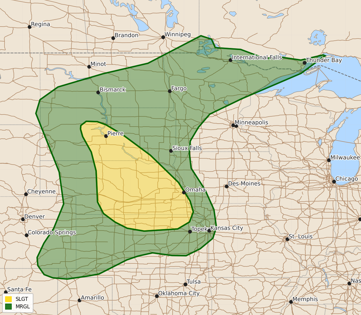
Summary
Severe thunderstorms capable of producing damaging wind gusts and hail are expected this evening across parts of South Dakota, Nebraska, and Kansas. Isolated severe storms may also occur across portions of the central High Plains, northern Plains, and upper Mississippi Valley.
Product Text
000 ACUS01 KWNS 310052 SWODY1 SPC AC 310050 Day 1 Convective Outlook NWS Storm Prediction Center Norman OK 0750 PM CDT Thu Jul 30 2026 Valid 310100Z - 311200Z ...THERE IS A SLIGHT RISK OF SEVERE THUNDERSTORMS ACROSS PARTS OF SOUTH DAKOTA AND NEBRASKA... ...SUMMARY... Thunderstorms with severe wind gusts and hail will be possible this evening from parts of central South Dakota southward into east-central Nebraska and northern Kansas. Isolated severe gusts may also occur in parts of the central High Plains, northern Plains and upper Mississippi Valley. ...Central and Northern Plains... A mid-level shortwave trough is evident on water vapor imagery from eastern South Dakota extending southwestward into Nebraska. Another more subtle shortwave trough appears to be moving through the northern High Plains. Strong to severe thunderstorms are ongoing ahead of each of these features, along and near an instability axis analyzed by the RAP from west-central South Dakota southeastward into central Nebraska. The greatest potential for severe storms this evening will be associated with a line segment that is located across central and northeastern Nebraska, which is near and to the northeast of the strongest instability. Along the instability corridor, the RAP has MLCAPE in the 2000 to 4000 J/kg range. The North Platte 00Z sounding is just to the west of the instability max and has 0-6 km shear around 30 knots, with 0-3 km lapse rates of 8 to 8.5 C/km. This environment will support a threat for severe wind gusts as the line moves southward across the remainder of central and eastern Nebraska over the next few hours. The wind-damage threat could persist into the late evening and early overnight, as the convective line moves from Nebraska into northern Kansas. Additional strong thunderstorms will be possible across parts of the central High Plains and from the northern Plains into the upper Mississippi Valley. However, instability is a bit weaker in these two areas suggesting that any severe threat should be marginal. ..Broyles.. 07/31/2026 $$