Mesoscale Discussion 1165
Issued: · Valid: –
Summary
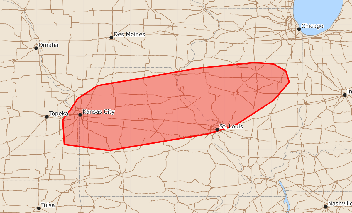
Severe thunderstorms capable of producing large hail, damaging winds, and strong tornadoes are expected this afternoon across portions of northern and central Missouri and western Illinois.
Product Text
000 ACUS11 KWNS 171804 SWOMCD SPC MCD 171803 ILZ000-MOZ000-IAZ000-KSZ000-172000- Mesoscale Discussion 1165 NWS Storm Prediction Center Norman OK 0103 PM CDT Wed Jun 17 2026 Areas affected...portions of northern/central Missouri...western Illinois Concerning...Severe potential...Watch likely Valid 171803Z - 172000Z Probability of Watch Issuance...95 percent SUMMARY...Thunderstorm development likely by the afternoon with potential for all hazards including damaging wind, large hail, and strong tornadoes. DISCUSSION...Morning convection has moved into central/eastern Illinois, with trailing outflow and a zone of differential heating extending across northern Missouri into south-central Illinois. This zone will be the focus of redevelopment of thunderstorm activity this afternoon. Strong daytime heating is ongoing across central/northern Missouri into far western Illinois in the cloud free zone south of the outflow. SPC Mesoanalysis indicates that MLCIN is eroding in this region, with temperatures climbing into the mid 80s F. This is further confirmed by visible satellite trends with the cumulus near the vicinity of the outflow also becoming increasingly agitated. Strong deep layer shear around 50-55 kts is analyzed across this region, with STP around 2-3 across northern Missouri into far western Illinois. This in combination with strong to moderate instability edging northward will likely support initial supercells capable of large hail, damaging wind, and tornadoes (perhaps strong). A 40-50 kt low level jet axis extends from the southern/central Plains into Missouri/western Illinois. This is progged to shift north and eastward through the afternoon, which may shift the higher STP and more favorable tornado potential into portions of western/central Illinois. One or more watches will likely be needed to cover this potential this afternoon. ..Thornton/Hart.. 06/17/2026 ...Please see www.spc.noaa.gov for graphic product... ATTN...WFO...LOT...ILX...LSX...DVN...SGF...EAX...TOP... LAT...LON 38788965 39578844 40158794 40518805 40738844 40788904 40599090 40469164 40309251 40129360 40049405 39629469 39309489 38959516 38169511 37979368 38499057 38619015 38788965 MOST PROBABLE PEAK TORNADO INTENSITY...140-170 MPH MOST PROBABLE PEAK WIND GUST...65-80 MPH MOST PROBABLE PEAK HAIL SIZE...2.00-3.50 IN