Day 1 Convective Outlook
Issued: · Valid: –
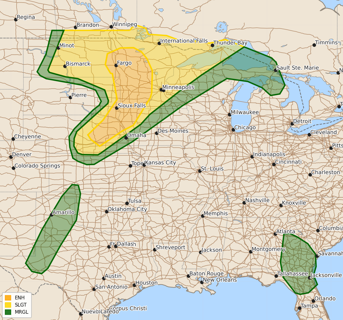
Summary
Severe thunderstorms capable of producing damaging winds, large hail, and tornadoes are expected this evening across the Dakotas, Upper Midwest, Middle Missouri Valley, and portions of the Texas and Oklahoma Panhandles. The most severe weather is expected in the Northern Plains and Midwest, where wind gusts could exceed 75 mph.
Product Text
000 ACUS01 KWNS 300053 SWODY1 SPC AC 300051 Day 1 Convective Outlook NWS Storm Prediction Center Norman OK 0751 PM CDT Mon Jun 29 2026 Valid 300100Z - 301200Z ...THERE IS AN ENHANCED RISK OF SEVERE THUNDERSTORMS PORTIONS OF THE MIDWEST AND CENTRAL PLAINS... ...SUMMARY... Severe thunderstorms are expected this evening across the Dakotas, Upper Midwest and Middle Missouri Valley, including damaging winds, large hail and a few tornadoes. ...Northern Plains and Midwest... Thunderstorm activity has initiated across eastern Nebraska near the cold front this evening, with additional areas of towering cu noted into northern Kansas. As the low-level jet strengthens and ascent increases with the approaching wave, it is likely additional thunderstorm development will occur into the evening. Guidance suggests that a mix of supercells and multi-cell clusters will emerge and spread east northeastward into far southeastern SD/northwestern IA and western MN. Strong to extreme instability and steep lapse rates downstream will likely support potential for damaging wind, with some significant gusts 75+ mph possible. Large to very large hail will also be possible where supercells can maintain semi-discrete mode. An upgrade to Enhanced was made with this update to account for this potential. See MCD#1386 for additional information on the short term severe potential. Further north across eastern North Dakota into western/central Minnesota near the surface low/warm front interface, potential will continue for supercells capable of all hazards including large hail, damaging wind, and strong tornadoes. See MCD#1387 for more information. ...Southwest Texas to the Texas/Oklahoma Panhandles... Thunderstorm activity continues across southwestern Texas into the Texas/Oklahoma Panhandles near the dryline. Very warm temperatures and dry mixed boundary layer conditions will continue to pose some potential for damaging winds until sunset this evening. ...Georgia into northern Florida Peninsula... A cluster of thunderstorms continues to move southwestward across southern/central Georgia this evening. Ahead of this cluster, hot and moderately unstable conditions will continue to pose potential for water loaded downdrafts that my produce strong to severe winds. ..Thornton.. 06/30/2026 $$