Day 1 Convective Outlook
This product has been superseded. View the updated product →
Issued: · Valid: –
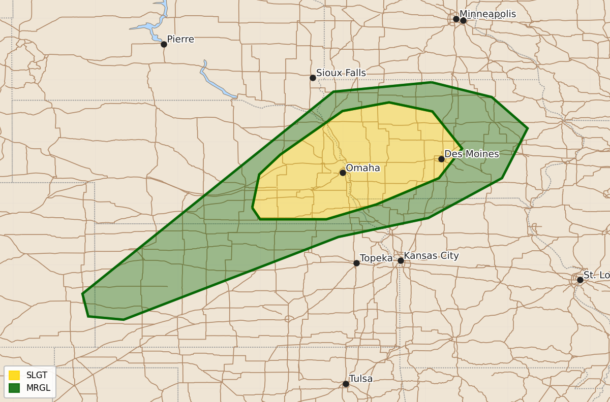
Summary
Strong to severe thunderstorms are possible across parts of eastern Nebraska and western Iowa late this afternoon and evening. These storms may produce large hail, damaging gusts, and tornadoes.
Product Text
000 ACUS01 KWNS 140544 SWODY1 SPC AC 140542 Day 1 Convective Outlook NWS Storm Prediction Center Norman OK 1242 AM CDT Mon Sep 14 2026 Valid 141200Z - 151200Z ...THERE IS A SLIGHT RISK OF SEVERE THUNDERSTORMS ACROSS EASTERN NE AND WESTERN IA... ...SUMMARY... Scattered strong to severe thunderstorms are possible across parts of eastern Nebraska into western Iowa late this afternoon and evening. ...Eastern NE/western IA... A strong mid/upper-level trough will move eastward from the northern Plains into the Upper Great Lakes through tonight. A deepening surface low will move across the Canadian Prairies, while a secondary low may develop along a trailing cold front/surface trough across the central High Plains. This system will be accompanied by strengthening deep-layer flow from the central Plains into the Upper Midwest. Extensive elevated convection will likely be ongoing at the start of the period from the mid Missouri Valley northward into the Dakotas and western MN. In the wake of this early-day convection, rich low-level moisture (with dewpoints in the 70s F) is forecast to stream northward into eastern NE and western IA. This moistening combined with relatively steep midlevel lapse rates will support moderate to strong destabilization by late afternoon, while low-level and deep-layer shear will become increasingly favorable with time. The resulting environment will become conditionally favorable for supercells capable of all severe hazards. The strongest large-scale ascent will become focused north of the region by afternoon, and it remains uncertain if heating in the wake of morning convection will be sufficient to remove CINH within the most favorable environment. If a supercell can become established and move through this environment during the late afternoon/early evening, then large to very large hail, localized damaging gusts, and tornadoes will all be possible. While most guidance depicts storm development by early evening, 00Z CAM guidance continues to vary regarding the potential for sustained supercells, with relatively quick clustering possible. Even in the absence of sustained supercell development, the environment will be favorable for severe hail and damaging wind with any persistent clusters into the evening. ...Western/north-central KS... Strong heating is expected near/south of a surface trough across parts of western/central KS this afternoon. Scattered storm development is expected by late afternoon from western into north-central KS. Deep-layer shear will be weaker with southwest extent, but steep low-level lapse rates and 25-35 kt of flow in the 850-500 mb layer will support potential for one or more loosely organized clusters with at least localized severe-wind potential. ...Four Corners region into AZ... Scattered storm development is expected later today from western CO and southeast UT into parts of AZ/NM, within an anomalously moist environment. The strongest mid/upper-level flow and deep-layer shear within this region is expected over parts of UT/CO, though it is uncertain if diurnal heating/destabilization will be sufficient for an organized severe threat in this area. Some threat for strong gusts and small to near-severe hail could evolve with the strongest storms. Farther south, flow will be weaker across AZ, resulting in generally disorganized storms. Localized strong gusts will be possible, especially in areas where stronger pre-storm heating occurs during the afternoon. ...Coastal NC... A cold front will move southward across NC through the day today. Large-scale ascent will generally be weak, though isolated storm development will be possible as the front encounters richer moisture and any sea breeze boundaries near the coast. Deep-layer shear within a northwesterly flow regime will be sufficient for organized convection, but poor midlevel lapse rates may limit updraft intensity and potential for an organized severe threat. Any sustained storms within this regime could produce locally gusty winds and small hail. ..Dean/Halbert.. 09/14/2026 $$