Day 3 Convective Outlook
Issued: · Valid: –
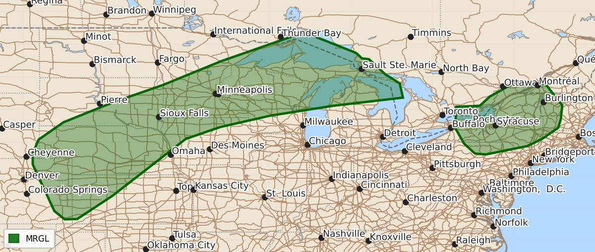
Summary
Marginal severe thunderstorms capable of producing damaging winds, hail, and isolated tornadoes are possible Tuesday across the central High Plains, the Upper Midwest, and parts of the Northeast.
Product Text
000 ACUS03 KWNS 281910 SWODY3 SPC AC 281909 Day 3 Convective Outlook NWS Storm Prediction Center Norman OK 0209 PM CDT Sun Jun 28 2026 Valid 301200Z - 011200Z ...THERE IS A MARGINAL RISK OF SEVERE THUNDERSTORMS FROM THE CENTRAL HIGH PLAINS TO THE UPPER GREAT LAKES...AND ACROSS PARTS OF THE NORTHEAST... ...SUMMARY... Severe thunderstorms will be possible from parts of the central High Plains into the Upper Midwest, and across parts of the Northeast on Tuesday. ...Mid-MO Valley to Upper Great Lakes... A compact upper low and attendant shortwave trough will be located over the Canadian Prairies into the Upper Midwest Tuesday morning. This system will progress east/northeast through the day. While large-scale ascent will increasing be focused north of the international border, stronger southwesterly deep-layer flow will persist for most of the day before weakening by evening. At the surface, a stalled surface front will be oriented from northeast MN into southeast SD/northern NE. Convection may be ongoing near this boundary somewhere in MN or perhaps northern WI/Michigan Upper Peninsula vicinity. A very moist airmass will be in place and strong to extreme instability is forecast through the day across portions of the region. If organized storms can develop, a risk for damaging winds and hail is possible - particularly if upscale development into a bowing segment occurs. Overall the forecast remains uncertain and any corridors of greater severe potential will be heavily influenced by remnant convection from the Day 2/Monday period and mesoscale impacts thereof. ...CO/KS/NE/SD... An upper shortwave impulse initially over the Great Basin early Tuesday will eject eastward across the central Rockies and into the adjacent High Plains during the evening/overnight hours. As this occurs, a lee surface low will develop. Increasing south/southeasterly low-level flow will transport modest boundary layer moisture north and west. Isolated storms may develop near the lee low and surface trough across eastern CO into western KS and northeastward across western NE into southern SD along the remnant cold front/effective warm front extending west to east near the NE/SD border. Damaging winds and hail are possible with this activity, though storm coverage and mesoscale details remain uncertain. ...Northeast... Most forecast guidance suggest storms will develop southeast across the region from Canada within a mid/upper-level northwesterly flow regime on the eastern periphery of an upper ridge. A very moist airmass will support a corridor of moderate to strong instability, though the north and eastward extent of stronger instability is uncertain. Forecast soundings indicated 25-35 kt effective shear magnitudes, and isolated supercells will be possible. If sufficient clustering or outflow consolidation occurs, a forward propagating band of storms also is possible. Damaging wind gusts will be the primary hazard, though isolated hail or even a tornado also will be possible depending on storm mode and evolution. If confidence increases in a corridor of greater severe potential higher probabilities may be needed in subsequent outlooks. ..Leitman.. 06/28/2026 $$