Day 2 Convective Outlook
Issued: · Valid: –
Summary
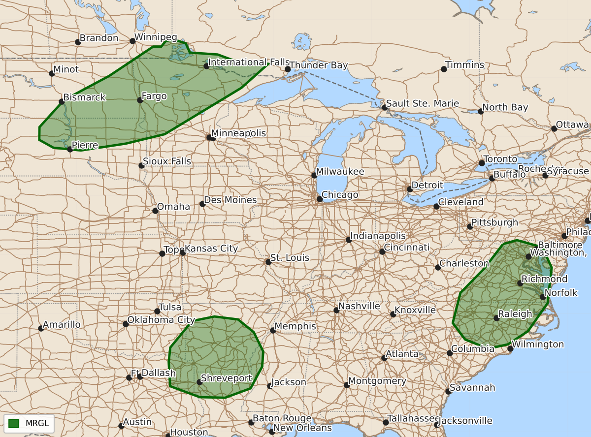
Marginal risk severe thunderstorms capable of large hail and damaging wind gusts are possible across the northern Plains into the Midwest, the Mid-Atlantic, and the lower Mississippi Valley from Sunday afternoon through Monday morning.
Product Text
000 ACUS02 KWNS 051732 SWODY2 SPC AC 051730 Day 2 Convective Outlook NWS Storm Prediction Center Norman OK 1230 PM CDT Sun Jul 05 2026 Valid 061200Z - 071200Z ...THERE IS A MARGINAL RISK OF SEVERE THUNDERSTORMS ACROSS THE NORTHERN PLAINS INTO THE MIDWEST...THE MID-ATLANTIC...AND LOWER MISSISSIPPI VALLEY... ...SUMMARY... Severe thunderstorms capable of large hail and severe gusts are possible across parts of the northern Plains into the Midwest. Damaging thunderstorm wind gusts are also possible across the Mid-Atlantic and lower Mississippi Valley. ...Northern Plains into the Midwest... Within the base of a midlevel trough moving eastward across SK/MB, modest midlevel height falls and a belt of 40-kt midlevel flow will overspread the northern Plains and upper Midwest. This will promote scattered thunderstorms along a southeastward-moving cold front during the afternoon into the nighttime hours. Rich boundary-layer moisture beneath steep midlevel lapse rates will yield strong buoyancy along/ahead of the front. This, combined with around 40 kt of effective shear, will promote a few organized clusters and possibly supercell structures capable of large hail and severe wind gusts. ...Mid-Atlantic... In the vicinity of a surface trough in the lee of the Blue Ridge, bands and clusters of storms will overspread a moist and strongly unstable air mass during the afternoon. Despite limited deep-layer shear and related storm organization, the environment will be conducive for damaging wind gusts with the stronger cores. ...Lower Mississippi Valley... An embedded midlevel impulse in the base of a broad, positive-tilt large-scale trough will provide a focus for scattered afternoon thunderstorm development across the lower MS Valley. Generally weak deep-layer shear will limit overall thunderstorm organization/longevity, though strong surface-based buoyancy and the potential for small bands/clusters of storms will favor damaging wind gusts. ..Weinman.. 07/05/2026 $$