Day 1 Convective Outlook
This product has been superseded. View the updated product →
Issued: · Valid: –
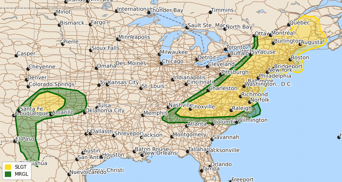
Summary
Severe thunderstorms capable of damaging winds and hail are expected this afternoon and evening across parts of the Appalachians, Mid-Atlantic, and Northeast. Additionally, severe storms with threats of hail, damaging gusts, and possible tornadoes may develop late this afternoon and evening across the south-central High Plains.
Product Text
000 ACUS01 KWNS 120601 SWODY1 SPC AC 120559 Day 1 Convective Outlook NWS Storm Prediction Center Norman OK 1259 AM CDT Fri Jun 12 2026 Valid 121200Z - 131200Z ...THERE IS A SLIGHT RISK OF SEVERE THUNDERSTORMS FOR PARTS OF THE APPALACHIANS...MID ATLANTIC...AND NORTHEAST...AND ALSO FOR PARTS OF THE SOUTH-CENTRAL HIGH PLAINS... ...SUMMARY... Strong to severe storms capable of damaging winds are possible across parts of the Appalachians, Mid Atlantic, and Northeast, mainly this afternoon and evening. Severe storms with a threat of hail and severe gusts will also be possible across parts of the south-central High Plains. ...Appalachians into the Mid Atlantic and Northeast... A vigorous mid/upper-level shortwave trough is forecast to move across Quebec later today, with weak midlevel height falls forecast to extend south of this shortwave into parts of the Appalachians, Northeast, and Mid Atlantic. The strongest deep-layer flow will remain north of the international border, but modest effective shear (generally 20-30 kt) will overlap relatively strong heating and modest buoyancy across parts of the Northeast/Mid Atlantic. Scattered outflow-driven clusters may develop with time and move eastward, with an attendant threat of damaging wind and perhaps isolated hail. Deep-layer flow/shear will be even weaker into parts of the southern Mid Atlantic/Carolinas vicinity. However, very strong heating of a moist airmass will support potential for scattered thunderstorms with downburst potential, and eventual evolution into loosely organized clusters capable of damaging outflow winds from afternoon into at least the early evening. ...South-central High Plains vicinity... Moist southerly low-level flow beneath steepening midlevel lapse rates will result in robust destabilization from the Raton Mesa vicinity into the adjacent south-central High Plains, with MLCAPE increasing to near/above 2000 J/kg by late afternoon. Modest westerly mid/upper-level flow will support effective shear of 30-35 kt, conditionally supportive of organized convection. Large-scale ascent will remain subtle, but eventual storms may develop by late afternoon near the higher terrain, and spread east-southeastward with time. Initial storms could evolve into isolated supercells, with a threat of hail, localized severe gusts, and possibly a tornado. Consolidating outflow and a nocturnally strengthening low-level jet will support some upscale growth during the evening, with an attendant severe-wind threat expected to spread across parts of the south-central High Plains. Farther south, more isolated strong to severe storms will be possible across parts of central/eastern NM into Far West TX, with a threat of isolated hail and localized severe gusts. ...Upper Midwest... Relatively low-topped convection may develop late this afternoon from the eastern Dakotas into MN, as low-level lapse rates steepen beneath seasonably cool temperatures aloft. Robust west-northwesterly flow aloft will conditionally favor some storm organization, if sufficient buoyancy can develop. However, most guidance depicts MLCAPE generally below 500 J/kg, with an inconsistent signal for where the deepest convection might develop. Some threat for marginal hail and/or locally damaging wind could evolve across some part of this region, and probabilities may be needed if confidence increases regarding sufficient destabilization and storm coverage. ...Parts of NE into western IA... Elevated convection may develop late in the period from parts of NE into western IA, within a warm-advection regime to the north of a warm front. Guidance continues to vary regarding the magnitude of elevated moistening/destabilization (which may be affected by MCS development to the south across KS) and coverage of storms prior to the end of the forecast period. Effective shear will be sufficient for at least modest storm organization and an isolated hail threat, if sufficient destabilization can occur. The aforementioned uncertainties and likely very late timing of any severe threat preclude the addition of hail probabilities at this time. ...Parts of OK/north TX... In the wake of morning convection, robust redevelopment cannot be ruled out across parts of OK/north TX, near a outflow-influenced surface boundary. Guidance varies substantially regarding the coverage/location of storms through mid morning, resulting in considerable uncertainty. Moderate to strong buoyancy and modest deep-layer shear could result in localized hail/wind potential, but confidence in boundary placement and diurnal storm coverage is too low for probabilities at this time. ..Dean/Weinman.. 06/12/2026 $$